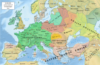
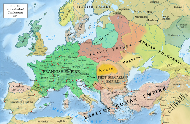
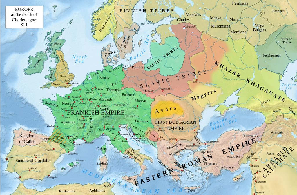
فائل:Europe 814.svg

اصل فائل (ایس وی جی فائل، ابعاد 1,399 × 919 پکسل، فائل کا حجم: 3.4 MB)
خلاصہ
| تفصیل |
English: An svg version of File:Europe 814.jpg with corrections.
List of corrections:
|
| تاریخ | |
| ماخذ | "The Public Schools Historical Atlas" by Charles Colbeck. Longmans, Green; New York; London; Bombay. 1905. |
| مصنف | Hel-hama |
| دوسرے نسخے |
|


_en.png)
.png)
.jpg)
اجازہ کاری
- آپ آزاد ہیں:
- شیئر کرنے – کام کو نقل، تقسیم یا منتقل کرنے کے لیے
- ریمکس کے لیے – کام منبطق کرنے کے لیے
- مندرجہ ذیل شرائط کے تحت:
- انتساب – آپ کو اس کام کا انتساب مصنف یا اجازت دہندہ کے بتائے گئے طریقہ کے مطابق دینا ہوگا (تاہم یہ انتساب اس طرح نہیں ہونا چاہیے کہ اسے دیکھ کر ایسا محسوس ہو کہ اصل مصنف یا اجازت دہندہ آپ کے یا آپ کے ذریعہ اس کام کے استعمال کرنے کے حامی ہیں)۔
- یکساں شراکت – اگر آپ اس کام میں کوئی تبدیلی یا ترمیم کرتے ہیں یا اس کام پر مبنی کچھ نیا بناتے ہیں تو اسے بھی آپ اسی یا اس جیسے کسی اجازت نامے کے تحت شائع کر سکتے ہیں۔
This media file is in the public domain in the United States. This applies to U.S. works where the copyright has expired, often because its first publication occurred prior to January 1, 1929, and if not then due to lack of notice or renewal. See this page for further explanation.
|
 | |
 |
This image might not be in the public domain outside of the United States; this especially applies in the countries and areas that do not apply the rule of the shorter term for US works, such as Canada, Mainland China (not Hong Kong or Macao), Germany, Mexico, and Switzerland. The creator and year of publication are essential information and must be provided. See Wikipedia:Public domain and Wikipedia:Copyrights for more details.
|
_(St_Edwards_Crown).svg)
|
This file is licensed under the Open Government Licence version 1.0 (OGL v1.0).
|
|---|---|
|
You are free to:
See the Open Government Licence page on Meta-Wiki for more information.
|
یہ تخلیق بھارت میں عوامی حق میں ہے کیونکہ اس کے کاپی رائٹ کی مدت ختم ہو گئی ہے. بھارتی کاپی رائٹ ایکٹ بھارت میں لاگو ہوتا ہے ان تخلیقات پر کام کرتا ہے جو سب سے پہلے بھارت میں شائع ہوں. بھارتی کاپی رائٹ ایکٹ، 1957 (باب V دفعہ 25 )، انام رچنا، تصویروں، فوٹوگرافی،، صوتی ریکارڈنگ، سركري دستاویز، اور کارپوریٹ گرنتھكارتا کی یا بین الاقوامی تنظیموں پر کام کرتا ہے کی تاریخ 60 سال کے بعد عوامی حقوق میں داخل ہو جاتے ہیں.
|
 |
فائل کا تاریخچہ
کسی خاص وقت یا تاریخ میں یہ فائل کیسی نظر آتی تھی، اسے دیکھنے کے لیے اس وقت/تاریخ پر کلک کریں۔
| تاریخ/وقت | تھمب نیل | ابعاد | صارف | تبصرہ | |
|---|---|---|---|---|---|
| رائج الوقت | 20:05، 8 جنوری 2023ء | | 1,399 × 919 (3.4 MB) | Miki Filigranski | correction of Bosnian border, which was a separate land according to modern scholarship, contested but never completelly under Serbian or Croatian control |
| 21:32، 29 نومبر 2022ء |  | 1,399 × 919 (3.39 MB) | Gyalu22 | Added Avar ethnic territory, see Bulgarians_and_Slavs_VI-VII_century.png. Also extended Magyar ethnic territory to Bessarabia | |
| 10:26، 1 نومبر 2022ء |  | 1,399 × 919 (3.38 MB) | Miki Filigranski | Reverted to version as of 07:20, 31 July 2022 (UTC) | |
| 04:47، 3 اگست 2022ء |  | 1,399 × 919 (3.38 MB) | Bernd21t | خلاصہ ترمیم حذف کیا | |
| 07:20، 31 جولائی 2022ء |  | 1,399 × 919 (3.38 MB) | Miki Filigranski | Reverted to version as of 16:51, 27 March 2022 (UTC) | |
| 05:13، 18 جولائی 2022ء |  | 1,399 × 919 (3.38 MB) | Ionelen | Reverted to version as of 19:41, 13 April 2022 (UTC) | |
| 07:41، 12 جولائی 2022ء |  | 1,399 × 919 (3.38 MB) | Ahmet Q. | Reverted to version as of 16:51, 27 March 2022 (UTC) | |
| 19:41، 13 اپریل 2022ء |  | 1,399 × 919 (3.38 MB) | Wojsław12 | Reverted to version as of 11:43, 14 January 2022 (UTC) | |
| 16:51، 27 مارچ 2022ء |  | 1,399 × 919 (3.38 MB) | Silverije | Reverted to version as of 12:43, 1 June 2021 (UTC) | |
| 11:43، 14 جنوری 2022ء |  | 1,399 × 919 (3.38 MB) | TómasdeAquino2 | Corrected POV issues of blocked sock of Crovata Miki Filigranski |
روابط
درج ذیل صفحہ اس فائل کو استعمال کر رہا ہے:
فائل کا عالمی استعمال
مندرجہ ذیل ویکیوں میں یہ فائل زیر استعمال ہے:
- af.wikipedia.org پر استعمال
- ar.wikipedia.org پر استعمال
- arz.wikipedia.org پر استعمال
- bg.wikipedia.org پر استعمال
- bn.wikipedia.org پر استعمال
- ca.wikipedia.org پر استعمال
- cs.wikipedia.org پر استعمال
- cy.wikipedia.org پر استعمال
- de.wikipedia.org پر استعمال
- el.wikipedia.org پر استعمال
- en.wikipedia.org پر استعمال
- Charlemagne
- History of Europe
- Vikings
- 814
- History of Estonia
- Bulgars
- Principality of Serbia (early medieval)
- Saare County
- Early Middle Ages
- Kvenland
- Askold and Dir
- Duchy of Benevento
- Portal:Estonia
- Franks
- Višeslav of Serbia
- History of Christian thought on persecution and tolerance
- Borna (duke)
- Vlastimir
- Arab–Khazar wars
- Duchy of Gascony
- Muslim conquest of Sicily
- Prosigoj
- Rus' people
- Early Slavs
- Radoslav of Serbia
- Barbarian kingdoms
- Agriculture in the Middle Ages
- Gersuinda
- User:Falcaorib
- en.wikibooks.org پر استعمال
اس فائل کا مزید عالمی استعمال دیکھیے۔