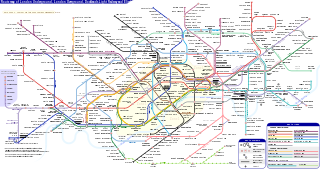
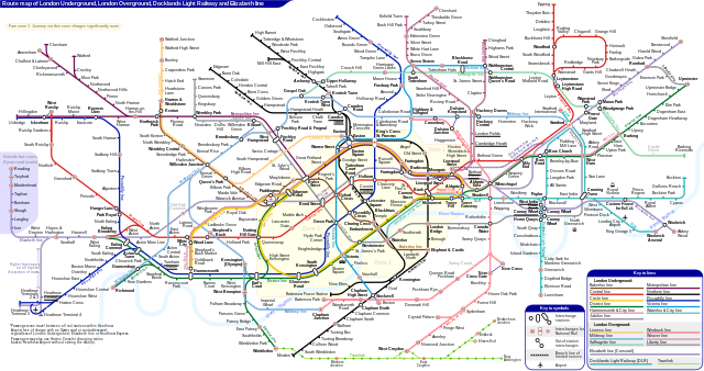
فائل:London Underground Overground DLR Crossrail map.svg

اس SVG فائل کی PNG نمائش کا حجم: 800 × 422 پکسلز دیگر تصمیمات: 320 × 169 پکسلز | 640 × 338 پکسلز | 1,024 × 541 پکسلز | 1,280 × 676 پکسلز | 2,560 × 1,352 پکسلز | 2,500 × 1,320 پکسلز۔
اصل فائل (متحرک ایس وی جی فائل، ابعاد 2,500 × 1,320 پکسل، فائل کا حجم: 219 کلوبائٹ)
اطلاع: تکنیکی پابندیوں کی وجہ سے اس فائل کے تھمب نیل غیر متحرک ہونگے۔
خلاصہ
| تفصیل |
English: *Route map of London Underground, London Overground, Docklands Light Railway and Elizabeth line (Crossrail), including most green-lighted proposals.
|
|||
| تاریخ | ||||
| ماخذ | ذاتی کام | |||
| مصنف | Sameboat | |||
| اجازت (فائل کا دوبارہ استعمال) |
میں اس تخلیقی کام کے حقوق کا مالک ہوں اور اسے مندرجہ ذیل اجازت نامے کے تحت شائع کرتا ہوں: This file is licensed under the Creative Commons Attribution-Share Alike 4.0 International license.
|
|||
| دوسرے نسخے |
|
|||
| SVG genesis | This icon was created with unknown tool. This icon uses embedded text that can be easily translated using a text editor. |


|
This image is an animated SVG file. The .png preview above created by RSVG for use in Wikimedia is not animated and may be incomplete or incorrect. To see the animation, open media:London Underground Overground DLR Crossrail map.svg. It should run in any modern browser or viewer. Recent versions of Chrome, Firefox, Microsoft Edge, Safari, and Opera all support SVG animated with SMIL.
Other SVG animations can be found at Category:Animated SVG files.
|

فائل کا تاریخچہ
کسی خاص وقت یا تاریخ میں یہ فائل کیسی نظر آتی تھی، اسے دیکھنے کے لیے اس وقت/تاریخ پر کلک کریں۔
| تاریخ/وقت | تھمب نیل | ابعاد | صارف | تبصرہ | |
|---|---|---|---|---|---|
| رائج الوقت | 06:27، 25 مارچ 2024ء | | 2,500 × 1,320 (219 کلوبائٹ) | Sameboat | change OOC icon to NR |
| 06:22، 23 مارچ 2024ء |  | 2,500 × 1,320 (219 کلوبائٹ) | Sameboat | restore changes made by The wub and Jc86035 | |
| 06:17، 23 مارچ 2024ء |  | 2,500 × 1,320 (219 کلوبائٹ) | Sameboat | + Old Oak Common | |
| 23:16، 19 مارچ 2024ء |  | 2,500 × 1,320 (219 کلوبائٹ) | The wub | Update cable car, add tooltip for Woolwich/Woolwich Arsenal interchange | |
| 21:54، 19 فروری 2024ء |  | 2,500 × 1,320 (219 کلوبائٹ) | Jc86035 | Wandsworth Road | |
| 01:09، 19 فروری 2024ء |  | 2,500 × 1,320 (219 کلوبائٹ) | Sameboat | ||
| 14:42، 16 فروری 2024ء |  | 2,500 × 1,320 (219 کلوبائٹ) | Sameboat | ||
| 14:37، 16 فروری 2024ء |  | 2,500 × 1,320 (219 کلوبائٹ) | Sameboat | overground new names and new colors | |
| 06:03، 7 نومبر 2022ء |  | 2,500 × 1,320 (221 کلوبائٹ) | Sameboat | Pudding Mill Lane portal | |
| 05:19، 6 نومبر 2022ء |  | 2,500 × 1,320 (224 کلوبائٹ) | Sameboat | Elizabeth line thru Paddington |
روابط
درج ذیل 9 صفحات اس فائل کو استعمال کر رہے ہیں:
فائل کا عالمی استعمال
مندرجہ ذیل ویکیوں میں یہ فائل زیر استعمال ہے:
- af.wikipedia.org پر استعمال
- ar.wikipedia.org پر استعمال
- ca.wikipedia.org پر استعمال
- de.wikipedia.org پر استعمال
- en.wikipedia.org پر استعمال
- Tube map
- Transport for London
- Schematic
- List of London Underground stations
- London Rail
- Portal:London
- Wikipedia:Wikipedia Signpost/2015-06-03/In the media
- Wikipedia:Wikipedia Signpost/Single/2015-06-03
- User:Bellowhead678/sandbox
- Elizabeth line
- User:RogerNiceEyes/sandbox
- Talk:Elizabeth line
- Glossary of geography terms (N–Z)
- en.wikivoyage.org پر استعمال
- es.wikipedia.org پر استعمال
- es.wikivoyage.org پر استعمال
- fa.wikipedia.org پر استعمال
- fi.wikipedia.org پر استعمال
- fr.wikipedia.org پر استعمال
- Liste des stations du métro de Londres
- Woodside Park (métro de Londres)
- Gare de Moorgate
- High Barnet (métro de Londres)
- Totteridge & Whetstone (métro de Londres)
- Morden (métro de Londres)
- Burnt Oak (métro de Londres)
- West Finchley (métro de Londres)
- Brent Cross (métro de Londres)
- Golders Green (métro de Londres)
- Kensal Green (métro de Londres)
- Queen's Park (métro de Londres)
- Finchley Central (métro de Londres)
- Colliers Wood (métro de Londres)
- Mill Hill East (métro de Londres)
- Edgware (métro de Londres)
- Balham (métro de Londres)
- Barking (métro de Londres)
- Colindale (métro de Londres)
- Hendon Central (métro de Londres)
اس فائل کا مزید عالمی استعمال دیکھیے۔