فائل:Map of Constantinople (1422) by Florentine cartographer Cristoforo Buondelmonte.jpg
اس نمائش کا حجم: 476 × 600 پکسلز۔ دیگر تصمیمات: 190 × 240 پکسلز | 592 × 746 پکسلز۔
اصل فائل (592 × 746 پکسل، فائل کا حجم: 838 کلوبائٹ، MIME قسم: image/jpeg)
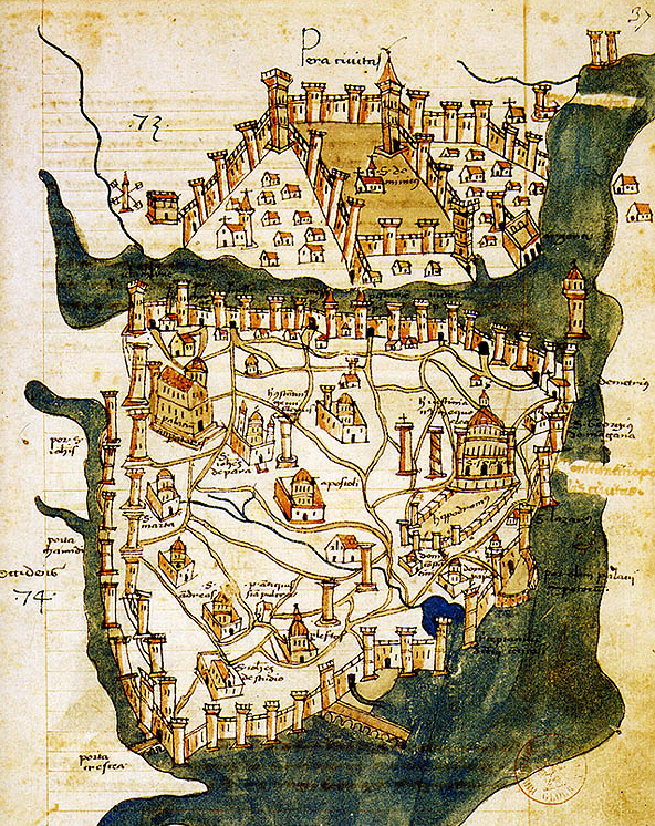
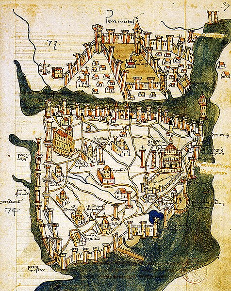
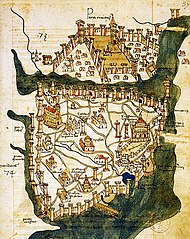
| تفصیل | Map of Constantinople (a small part of modern Istanbul), called "Historic Peninsula", Tarihi Yarımada en Turkish) designed in 1422 by Florentine cartographer Cristoforo Buondelmonti (Description des îles de l'archipel, Bibliothèque nationale, Paris) is the oldest surviving map of the city, and the only surviving map which predates the Turkish conquest of Constantinople in 1453. | ||||
| تاریخ | |||||
| ماخذ | Liber insularum Archipelagi (1824), version available at the Bibliothèque nationale de France, Paris | ||||
| مصنف | Cristoforo Buondelmonti | ||||
| اجازت (فائل کا دوبارہ استعمال) |
|
||||
| دوسرے نسخے |
|
||||

_by_Florentine_cartographer_Cristoforo_Buondelmonte.jpg)
فائل کا تاریخچہ
کسی خاص وقت یا تاریخ میں یہ فائل کیسی نظر آتی تھی، اسے دیکھنے کے لیے اس وقت/تاریخ پر کلک کریں۔
| تاریخ/وقت | تھمب نیل | ابعاد | صارف | تبصرہ | |
|---|---|---|---|---|---|
| رائج الوقت | 10:24، 25 جون 2007ء | | 592 × 746 (838 کلوبائٹ) | M.K. | {{Information |Description=Map of Constantinople (1422) by Florentine cartographer Cristoforo Buondelmonte (''Description des îles de l'archipel'', Bibliothèque nationale, Paris) is the oldest surviving map of the city, and the only surviving ma |
روابط
درج ذیل صفحہ اس فائل کو استعمال کر رہا ہے:
فائل کا عالمی استعمال
مندرجہ ذیل ویکیوں میں یہ فائل زیر استعمال ہے:
- ar.wikipedia.org پر استعمال
- az.wikipedia.org پر استعمال
- ba.wikipedia.org پر استعمال
- bg.wikipedia.org پر استعمال
- ca.wikipedia.org پر استعمال
- ce.wikipedia.org پر استعمال
- cs.wikipedia.org پر استعمال
- de.wikipedia.org پر استعمال
- el.wikipedia.org پر استعمال
- en.wikipedia.org پر استعمال
- Bosporus
- Constantinople
- Constantine XI Palaiologos
- John VII Palaiologos
- Walls of Constantinople
- Beyoğlu
- Maiden's Tower
- Siege of Constantinople (1422)
- Siege of Constantinople (1411)
- Template:Did you know nominations/Kontoskalion
- Piyalepaşa, Beyoğlu
- Wikipedia:Main Page history/2019 February 23
- Siege of Constantinople (1394–1402)
- es.wikipedia.org پر استعمال
- et.wikipedia.org پر استعمال
- eu.wikipedia.org پر استعمال
- fa.wikipedia.org پر استعمال
- frp.wikipedia.org پر استعمال
- fr.wikipedia.org پر استعمال
اس فائل کا مزید عالمی استعمال دیکھیے۔
_by_Florentine_cartographer_Cristoforo_Buondelmonte.jpg)
_by_Florentine_cartographer_Cristoforo_Buondelmonte.jpg)