فائل:PAK AU T1.svg

اس SVG فائل کی PNG نمائش کا حجم: 750 × 600 پکسلز دیگر تصمیمات: 300 × 240 پکسلز | 600 × 480 پکسلز | 960 × 768 پکسلز | 1,280 × 1,024 پکسلز | 2,560 × 2,048 پکسلز | 1,000 × 800 پکسلز۔
اصل فائل (ایس وی جی فائل، ابعاد 1,000 × 800 پکسل، فائل کا حجم: 19 کلوبائٹ)
خلاصہ
| تفصیل |
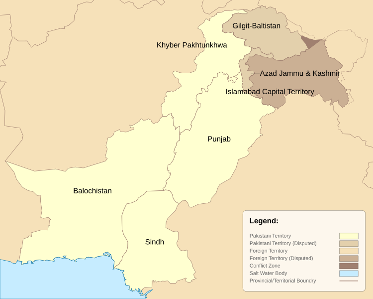
English: Pakistan Administrative Units - Tier 1. This map is based on the Pakistan location map and district maps obtained from respective government websites of Punjab, Sindh, Balochistan and Khyber Pakhtunkhwah. The map has been greatly simplified by reducing the number of data points to reduce file size and modified to include the latest districts as of 2010. |
| تاریخ | |
| ماخذ | ذاتی کام |
| مصنف | Schajee |
| دوسرے نسخے |
|


اجازہ کاری
| میں اس تخلیقی کام کے حقوق کا مالک ہوں اور اسے دائرہ عام میں شائع کرتا ہوں جس کا اطلاق عالمی سطح پر ہوتا ہے۔ بعض ملکوں میں یہ قانونی طور پر شاید ممکن نہ ہو؛ اگر ایسا ہے تو: میں ہر ایک کو کسی بھی مقصد کے لیے بغیر کسی شرط کے اس تصویر کے استعمال کا حق تفویض کرتا/کرتی ہوں، بجز اس صورت کے جس میں کوئی قانونی رکاوٹ موجود ہو۔ |
فائل کا تاریخچہ
کسی خاص وقت یا تاریخ میں یہ فائل کیسی نظر آتی تھی، اسے دیکھنے کے لیے اس وقت/تاریخ پر کلک کریں۔
| تاریخ/وقت | تھمب نیل | ابعاد | صارف | تبصرہ | |
|---|---|---|---|---|---|
| رائج الوقت | 23:04، 14 فروری 2021ء | | 1,000 × 800 (19 کلوبائٹ) | M Imtiaz | As the previous uploader said, territorial disputes between China and India are irrelevant to this map as long as Pakistan does not claim those territories as part of itself, so I have changed the colour of Shaksgram, Aqsai Chin, etc. accordingly. |
| 08:43، 25 اکتوبر 2020ء |  | 1,000 × 800 (19 کلوبائٹ) | Swtadi143 | This should only show area in names whoch pakistan claims instead of showing areas disputed by India like shaksgam valley which is a dispute between china and India and not pakistan and India this map is wrong to show the administrative map of pakistan so I am reverting it Reverted to version as of 20:35, 2 June 2018 (UTC) | |
| 18:49، 5 ستمبر 2019ء |  | 1,000 × 800 (22 کلوبائٹ) | SPQR10 | Added Jammu & Kashmir,Siachen Galcier,Shaksgam Valley | |
| 20:35، 2 جون 2018ء |  | 1,000 × 800 (19 کلوبائٹ) | ASDFGH | FATA merged into KP | |
| 18:37، 10 اکتوبر 2010ء |  | 1,000 × 800 (15 کلوبائٹ) | Schajee | Converted polygons to paths; added legend; | |
| 11:54، 8 اکتوبر 2010ء |  | 1,000 × 800 (18 کلوبائٹ) | Schajee | Adjusted text-alignment and shading for disputed territories | |
| 10:59، 8 اکتوبر 2010ء |  | 1,000 × 800 (18 کلوبائٹ) | Schajee | Reduced file size by simplifying outlines. Colors are now in accordance with Wikipedia Map Guidelines. | |
| 02:37، 27 ستمبر 2010ء |  | 685 × 500 (113 کلوبائٹ) | Schajee | Fixed Height/Width issue Changed Colors | |
| 02:35، 27 ستمبر 2010ء |  | 685 × 500 (114 کلوبائٹ) | Schajee | Reverted to version as of 18:26, 20 September 2010 | |
| 02:34، 27 ستمبر 2010ء |  | 512 × 512 (113 کلوبائٹ) | Schajee | Added pattern for disputed regions Fixed name for Khyber Pakhtunkhwah |
روابط
درج ذیل صفحہ اس فائل کو استعمال کر رہا ہے:
فائل کا عالمی استعمال
مندرجہ ذیل ویکیوں میں یہ فائل زیر استعمال ہے:
- be-tarask.wikipedia.org پر استعمال
- be.wikipedia.org پر استعمال
- bn.wikipedia.org پر استعمال
- en.wikipedia.org پر استعمال
- es.wikipedia.org پر استعمال
- fr.wikipedia.org پر استعمال
- id.wikipedia.org پر استعمال
- is.wikipedia.org پر استعمال
- kn.wikipedia.org پر استعمال
- mzn.wikipedia.org پر استعمال
- pa.wikipedia.org پر استعمال
- pt.wikipedia.org پر استعمال
- sd.wikipedia.org پر استعمال
- tg.wikipedia.org پر استعمال
- vi.wikipedia.org پر استعمال