فائل:Pub161-pgIV.jpg

اس نمائش کا حجم: 486 × 600 پکسلز۔ دیگر تصمیمات: 194 × 240 پکسلز | 389 × 480 پکسلز | 770 × 950 پکسلز۔
اصل فائل (770 × 950 پکسل، فائل کا حجم: 108 کلوبائٹ، MIME قسم: image/jpeg)
خلاصہ
| تفصیل |
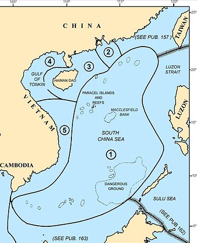
Map of the w:South China Sea region showing the areas covered by NGA Pub. 161, Sailing Directions (Enroute) South China Sea and the Gulf of Thailand, Fifteenth Edition, 2014 |
| تاریخ | |
| ماخذ |
Page IV of http://msi.nga.mil/MSISiteContent/StaticFiles/NAV_PUBS/SD/Pub161/Pub161bk.pdf |
| مصنف |
National Geospatial-Intelligence Agency (NGA), |
| اجازت (فائل کا دوبارہ استعمال) |
© COPYRIGHT 2014 BY THE UNITED STATES GOVERNMENT NO COPYRIGHT CLAIMED UNDER TITLE 17 U.S.C. |
| دوسرے نسخے |
 File:Pub161-pg1.jpg File:Pub161-pg1.jpg |
اجازہ کاری
This work is in the public domain in the United States because it is a work prepared by an officer or employee of the United States Government as part of that person’s official duties under the terms of Title 17, Chapter 1, Section 105 of the US Code.
Note: This only applies to original works of the Federal Government and not to the work of any individual U.S. state, territory, commonwealth, county, municipality, or any other subdivision. This template also does not apply to postage stamp designs published by the United States Postal Service since 1978. (See § 313.6(C)(1) of Compendium of U.S. Copyright Office Practices). It also does not apply to certain US coins; see The US Mint Terms of Use.
|
 | |
| This file has been identified as being free of known restrictions under copyright law, including all related and neighboring rights. | ||
فائل کا تاریخچہ
کسی خاص وقت یا تاریخ میں یہ فائل کیسی نظر آتی تھی، اسے دیکھنے کے لیے اس وقت/تاریخ پر کلک کریں۔
| تاریخ/وقت | تھمب نیل | ابعاد | صارف | تبصرہ | |
|---|---|---|---|---|---|
| رائج الوقت | 04:44، 30 نومبر 2014ء | | 770 × 950 (108 کلوبائٹ) | Pdfpdf | trim off top border (2 pixels) |
| 04:26، 30 نومبر 2014ء |  | 770 × 952 (109 کلوبائٹ) | Pdfpdf | {{Information |Description= Map of the w:South China Sea region showing the areas covered by NGA Pub. 161, ''Sailing Directions (Enroute) South China Sea and the Gulf of Thailand'', Fifteenth Edition, 2014 |Source=Page IV of http://msi.nga.mil/MSIS... |
روابط
درج ذیل صفحہ اس فائل کو استعمال کر رہا ہے:
فائل کا عالمی استعمال
مندرجہ ذیل ویکیوں میں یہ فائل زیر استعمال ہے:
- en.wikipedia.org پر استعمال
- fr.wikipedia.org پر استعمال
- vi.wikipedia.org پر استعمال
- www.wikidata.org پر استعمال
- zh.wikipedia.org پر استعمال