فائل:Santa lucia praslin political.png

اس نمائش کا حجم: 424 × 599 پکسلز۔ دیگر تصمیمات: 170 × 240 پکسلز | 339 × 480 پکسلز | 733 × 1,036 پکسلز۔
اصل فائل (733 × 1,036 پکسل، فائل کا حجم: 23 کلوبائٹ، MIME قسم: image/png)
خلاصہ
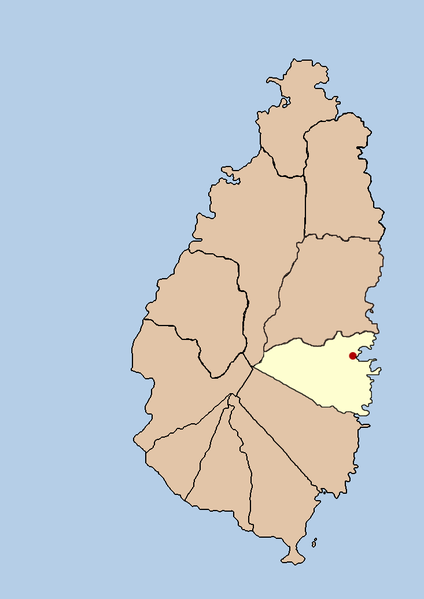
| تفصیل | this is a political map showing the quarter of Praslin on the island nation of Santa Lucia. I created it myself by using the GIMP to trace a public domain map that i found at the Perry-Castañeda Library Map Collection. |
| تاریخ | 21 ستمبر 2005 (original upload date) |
| ماخذ | No machine-readable source provided. Own work assumed (based on copyright claims). |
| مصنف | No machine-readable author provided. Doviende~commonswiki assumed (based on copyright claims). |
اجازہ کاری
| میں اس تخلیقی کام کے حقوق کا مالک ہوں اور اسے دائرہ عام میں شائع کرتا ہوں جس کا اطلاق عالمی سطح پر ہوتا ہے۔ بعض ملکوں میں یہ قانونی طور پر شاید ممکن نہ ہو؛ اگر ایسا ہے تو: میں ہر ایک کو کسی بھی مقصد کے لیے بغیر کسی شرط کے اس تصویر کے استعمال کا حق تفویض کرتا/کرتی ہوں، بجز اس صورت کے جس میں کوئی قانونی رکاوٹ موجود ہو۔ |

|
File:Saint Lucia district of Praslin.svg is a vector version of this file. It should be used in place of this PNG file when not inferior.
File:Santa lucia praslin political.png → File:Saint Lucia district of Praslin.svg
For more information, see Help:SVG. |
 |
فائل کا تاریخچہ
کسی خاص وقت یا تاریخ میں یہ فائل کیسی نظر آتی تھی، اسے دیکھنے کے لیے اس وقت/تاریخ پر کلک کریں۔
| تاریخ/وقت | تھمب نیل | ابعاد | صارف | تبصرہ | |
|---|---|---|---|---|---|
| رائج الوقت | 03:42، 21 ستمبر 2005ء | | 733 × 1,036 (23 کلوبائٹ) | Doviende~commonswiki | this is a political map showing the quarter of Praslin on the island nation of Santa Lucia. I created it myself by using the GIMP to trace [http://www.lib.utexas.edu/maps/americas/saint_lucia.gif a public domain map that i found] at the Perry-Castañ |
| 03:36، 21 ستمبر 2005ء |  | 733 × 1,036 (21 کلوبائٹ) | Doviende~commonswiki | this is a political map showing the quarter of Praslin on the island nation of Santa Lucia. I created it myself by using the GIMP to trace [http://www.lib.utexas.edu/maps/americas/saint_lucia.gif|a public domain map that i found] at the Perry-Castañ |
روابط
درج ذیل صفحہ اس فائل کو استعمال کر رہا ہے:
فائل کا عالمی استعمال
مندرجہ ذیل ویکیوں میں یہ فائل زیر استعمال ہے:
- eo.wikipedia.org پر استعمال
- fa.wikipedia.org پر استعمال
- ko.wikipedia.org پر استعمال
- vi.wikipedia.org پر استعمال