فائل:1973 sinai war maps.jpg

اصل فائل (1,165 × 894 پکسل، فائل کا حجم: 217 کلوبائٹ، MIME قسم: image/jpeg)
خلاصہ
| تفصیل |
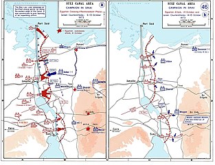
العربية: خريطة للتحركات العسكرية على الجبهة المصرية في حرب أكتوبر في الفترة بين 6 و 13 أكتوبر.
English: Sinai maps, from the US Military Academy History archives (copyright US government?)
Background information: In 1938 the predecessors of what is today The Department of History at the United States Military Academy began developing a series of campaign atlases to aid in teaching cadets a course entitled, "History of the Military Art." Since then, the Department has produced over six atlases and more than one thousand maps, encompassing not only America’s wars but global conflicts as well. In keeping abreast with today's technology, the Department of History is providing these maps on the internet as part of the department's outreach program. The maps were created by the United States Military Academy’s Department of History and are the digital versions from the atlases printed by the United States Defense Printing Agency. We gratefully acknowledge the accomplishments of the department's former cartographer, Mr. Edward J. Krasnoborski, along with the works of our present cartographer, Mr. Frank Martini. Please be aware that these maps are large in file size and may require substantial download times.. |
| تاریخ | 2005-04-220 |
| ماخذ |
|
| مصنف | Ondrejk |
| دوسرے نسخے |
 |
This file is a work of a U.S. Army soldier or employee, taken or made as part of that person's official duties. As a work of the U.S. federal government, it is in the public domain in the United States.
|
 |
Downloaded and copied from EN-wiki
فائل کا تاریخچہ
کسی خاص وقت یا تاریخ میں یہ فائل کیسی نظر آتی تھی، اسے دیکھنے کے لیے اس وقت/تاریخ پر کلک کریں۔
| تاریخ/وقت | تھمب نیل | ابعاد | صارف | تبصرہ | |
|---|---|---|---|---|---|
| رائج الوقت | 21:06، 1 جون 2009ء | | 1,165 × 894 (217 کلوبائٹ) | Hohum | Cleaned up |
| 18:09، 20 اپریل 2005ء |  | 1,165 × 894 (174 کلوبائٹ) | Thuresson | larger size | |
| 17:56، 20 اپریل 2005ء |  | 1,000 × 765 (63 کلوبائٹ) | Ondrejk | Sinai maps, from the US Military Academy History archives (copyright US government?) Source: Department of History, U.S. Military Academy {{PD-USGov}} Downloaded and copied from EN-wiki |
روابط
درج ذیل صفحہ اس فائل کو استعمال کر رہا ہے:
فائل کا عالمی استعمال
مندرجہ ذیل ویکیوں میں یہ فائل زیر استعمال ہے:
- af.wikipedia.org پر استعمال
- ast.wikipedia.org پر استعمال
- bg.wikipedia.org پر استعمال
- ca.wikipedia.org پر استعمال
- cy.wikipedia.org پر استعمال
- da.wikipedia.org پر استعمال
- de.wikipedia.org پر استعمال
- el.wikipedia.org پر استعمال
- en.wikipedia.org پر استعمال
- eo.wikipedia.org پر استعمال
- es.wikipedia.org پر استعمال
- eu.wikipedia.org پر استعمال
- fi.wikipedia.org پر استعمال
- fr.wikipedia.org پر استعمال
- gl.wikipedia.org پر استعمال
- he.wikipedia.org پر استعمال
- id.wikipedia.org پر استعمال
- it.wikipedia.org پر استعمال
- it.wikibooks.org پر استعمال
- ja.wikipedia.org پر استعمال
- jv.wikipedia.org پر استعمال
- lv.wikipedia.org پر استعمال
- ms.wikipedia.org پر استعمال
- ne.wikipedia.org پر استعمال
- nl.wikipedia.org پر استعمال
- nn.wikipedia.org پر استعمال
- no.wikipedia.org پر استعمال
اس فائل کا مزید عالمی استعمال دیکھیے۔