فائل:20180221-OSEC-LSC-0055 (39518128545).jpg

اس نمائش کا حجم: 800 × 533 پکسلز۔ دیگر تصمیمات: 320 × 213 پکسلز | 640 × 427 پکسلز | 1,024 × 683 پکسلز | 1,280 × 853 پکسلز | 2,560 × 1,707 پکسلز | 8,256 × 5,504 پکسلز۔
اصل فائل (8,256 × 5,504 پکسل، فائل کا حجم: 33.99 MB، MIME قسم: image/jpeg)
.jpg)
خلاصہ
| تفصیل |
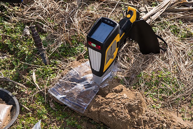
English: Chesapeake Bay Foundation Clagett Farm welcomes U.S. Department of Agriculture (USDA) Agricultural Outlook Forum (AOF) Farm Conservation Tour participants and gives them an overview of Clagett Farm and the conservation practices that have been implemented in partnership with Natural Resource Conservation Service (NRCS) in Upper Marlboro, Maryland, on Feb. 21, 2018. The foundation and NRCS staff will discuss the implementation process of conservation plans that address soil health, drainage solutions and farm road designs. U.S. Department of Agriculture (USDA) Natural Resource Conservation Service (NRCS) District of Columbia, Delaware, Maryland State Soil Scientist Phillip King demonstrates the deployment of the Olympus Delta Professional XRF hand-held device that determines the amount of metal contaminants within the soil. The contaminants of concern are lead, mercury, cadmium and arsenic. Once identified, a land owner can choose not to use the land or address the problem with a remedial activity.
This technology provides an efficient and timely analysis for the customer so that they can make their land use decisions. Previously, aerial surveys and excavations were needed to get soil samples that were sent to laboratories for analysis. The increased use of surburban/urban interfaces for agricultural production is one of the reasons this device was brought into service is to detect metal content in soil that people may have put on the land. USDA Departmental Administration Radiation Safety Division Specialist Katina Jones, red shirt, takes advantage of the nearby XRF device demonstration to get some field measurements of natural radiation in the area and then near the device in various modes. No problems were detected. Français : Chesapeake Bay Foundation Clagett Farm accueille les participants à la visite de conservation de la ferme du Département américain de l'agriculture (USDA) du Forum sur les perspectives agricoles (AOF) et leur donne un aperçu de Clagett Farm et des pratiques de conservation qui ont été mises en œuvre en partenariat avec le Natural Resource Conservation Service (NRCS) dans Upper Marlboro, Maryland, le 21 février 2018. La fondation et le personnel du NRCS discuteront du processus de mise en œuvre des plans de conservation qui traitent de la santé des sols, des solutions de drainage et de la conception des routes agricoles. Département américain de l'agriculture (USDA) Service de conservation des ressources naturelles (NRCS) District de Columbia, Delaware, État du Maryland Le pédologue Phillip King démontre le déploiement de l'appareil portatif Olympus Delta Professional XRF qui détermine la quantité de contaminants métalliques dans le sol. Les contaminants préoccupants sont le plomb, le mercure, le cadmium et l'arsenic. Une fois identifié, un propriétaire foncier peut choisir de ne pas utiliser le terrain ou de résoudre le problème avec une activité corrective. Cette technologie fournit une analyse efficace et rapide au client afin qu'il puisse prendre ses décisions en matière d'utilisation des terres. Auparavant, des levés aériens et des fouilles étaient nécessaires pour obtenir des échantillons de sol qui étaient envoyés aux laboratoires pour analyse. L'utilisation accrue des interfaces périurbain/urbain pour la production agricole est l'une des raisons pour lesquelles cet appareil a été mis en service pour détecter la teneur en métaux dans le sol que les gens ont pu mettre sur le terrain. La spécialiste de la division de la radioprotection de l'administration départementale de l'USDA, Katina Jones, chemise rouge, profite de la démonstration de l'appareil XRF à proximité pour obtenir des mesures sur le terrain du rayonnement naturel dans la zone, puis à proximité de l'appareil dans différents modes. ici, aucun problème n'a été détecté.
USDA Photo by Lance Cheung. |
| تاریخ | |
| ماخذ | 20180221-OSEC-LSC-0055 |
| مصنف | U.S. Department of Agriculture |
| اجازت (فائل کا دوبارہ استعمال) |
Flinfo has extracted the license below from the metadata of the image (tag "IFD0:ImageDescription" contained "USDA Photo"). The license visible at Flickr was "Public Domain Mark". |
| Camera location | | View this and other nearby images on: OpenStreetMap |
|---|
.jpg¶ms=038.819730_N_-076.803478_E_globe:Earth_type:camera_source:Flickr_&language=ur)
اجازہ کاری
This image or file is a work of a United States Department of Agriculture employee, taken or made as part of that person's official duties. As a work of the U.S. federal government, the image is in the public domain.
|
 |
| This image was originally posted to Flickr by USDAgov at https://flickr.com/photos/41284017@N08/39518128545 (archive). It was reviewed on 22 فروری 2018 by FlickreviewR 2 and was confirmed to be licensed under the terms of the Public Domain Mark. |
فائل کا تاریخچہ
کسی خاص وقت یا تاریخ میں یہ فائل کیسی نظر آتی تھی، اسے دیکھنے کے لیے اس وقت/تاریخ پر کلک کریں۔
| تاریخ/وقت | تھمب نیل | ابعاد | صارف | تبصرہ | |
|---|---|---|---|---|---|
| رائج الوقت | 08:18، 22 فروری 2018ء | | 8,256 × 5,504 (33.99 MB) | Junior Jumper | Transferred from Flickr via Flickr2Commons |
روابط
درج ذیل صفحہ اس فائل کو استعمال کر رہا ہے:
فائل کا عالمی استعمال
مندرجہ ذیل ویکیوں میں یہ فائل زیر استعمال ہے:
- cy.wikipedia.org پر استعمال
- de.wikipedia.org پر استعمال
- en.wikipedia.org پر استعمال
- et.wikipedia.org پر استعمال
- fr.wikipedia.org پر استعمال
- ig.wikipedia.org پر استعمال
.jpg)