فائل:Azores old map.jpg

اصل فائل (2,104 × 1,480 پکسل، فائل کا حجم: 678 کلوبائٹ، MIME قسم: image/jpeg)
خلاصہ

|
This old map image could be re-created using vector graphics as an SVG file. This has several advantages; see Commons:Media for cleanup for more information. If an SVG form of this image is available, please upload it and afterwards replace this template with
{{vector version available|new image name}}.
It is recommended to name the SVG file “Azores old map.svg”—then the template Vector version available (or Vva) does not need the new image name parameter. |


| تفصیل |
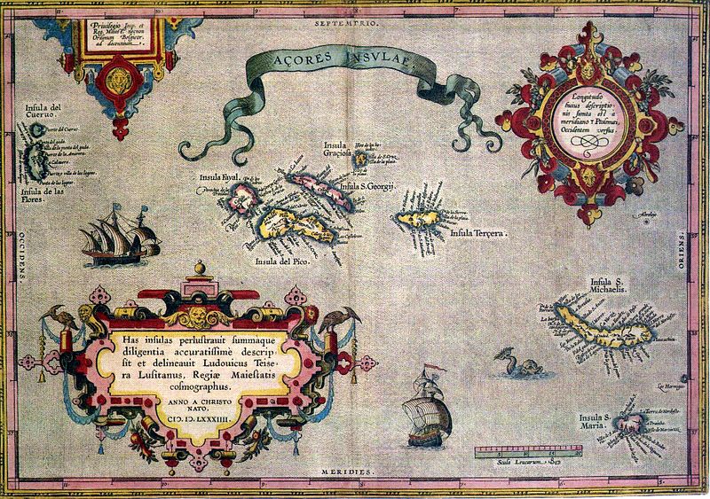
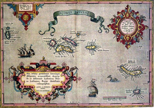
English: Sixteenth-century map of Azores. Legend, in Latin: "Has insulas perlustrauit summàque diligentia accuratissimè descripsit et delineauit Ludovicus Teisera Lusitanus, Regiæ Maiestatis cosmographus. ANNO A CHRISTO NATO, M.D.LXXXIIII" ("These islands were illustrated and described with great diligence and drawn by the Portuguese Luís Teixeira, his royal majesty's cartographer, AD 1584.") Deutsch: alte Karte der Azoren Português: "Açores Insulae" ("Ilhas dos Açores"), Luís Teixeira, c. 1584. A legenda, em latim - "Has insulas perlustrauit summàque diligentia accuratissimè descripsit et delineauit Ludovicus Teisera Lusitanus, Regiæ Maiestatis cosmographus. ANNO A CHRISTO NATO, M.D.LXXXIIII" -, pode ser traduzida livremente como: "Estas ilhas foram percorridas com a maior diligência, e com todo o cuidado as descreveu o português Luís Teixeira, cosmógrafo da Majestade Real. Ano do nascimento de Cristo de 1584." |
| تاریخ | |
| ماخذ | see above |
| مصنف | Abraham Ortelius |
اجازہ کاری
|
This is a faithful photographic reproduction of a two-dimensional, public domain work of art. The work of art itself is in the public domain for the following reason:
The official position taken by the Wikimedia Foundation is that "faithful reproductions of two-dimensional public domain works of art are public domain". This photographic reproduction is therefore also considered to be in the public domain in the United States. In other jurisdictions, re-use of this content may be restricted; see Reuse of PD-Art photographs for details. {{PD-Art}} template without license parameter: please specify why the underlying work is public domain in both the source country and the United States
(Usage: {{PD-Art|1=|deathyear=''year of author's death''|country=''source country''}}, where parameter #1 can be PD-old-auto, PD-old-auto-expired, PD-old-auto-1996, PD-old-100 or similar. See Commons:Multi-license copyright tags for more information.) | ||||
فائل کا تاریخچہ
کسی خاص وقت یا تاریخ میں یہ فائل کیسی نظر آتی تھی، اسے دیکھنے کے لیے اس وقت/تاریخ پر کلک کریں۔
| تاریخ/وقت | تھمب نیل | ابعاد | صارف | تبصرہ | |
|---|---|---|---|---|---|
| رائج الوقت | 06:59، 17 جولائی 2005ء | | 2,104 × 1,480 (678 کلوبائٹ) | Nataraja~commonswiki | |
| 02:16، 17 جولائی 2005ء |  | 2,104 × 1,480 (635 کلوبائٹ) | Angrense | Abraham Ortelius map of the Azores (c. 1585). {{PD}} Category:Azores |
روابط
درج ذیل صفحہ اس فائل کو استعمال کر رہا ہے:
فائل کا عالمی استعمال
مندرجہ ذیل ویکیوں میں یہ فائل زیر استعمال ہے:
- als.wikipedia.org پر استعمال
- an.wikipedia.org پر استعمال
- ca.wikipedia.org پر استعمال
- da.wikipedia.org پر استعمال
- de.wikipedia.org پر استعمال
- el.wikipedia.org پر استعمال
- en.wikipedia.org پر استعمال
- eo.wikipedia.org پر استعمال
- es.wikipedia.org پر استعمال
- fa.wikipedia.org پر استعمال
- fi.wikipedia.org پر استعمال
- fr.wikipedia.org پر استعمال
- gl.wikipedia.org پر استعمال
- id.wikipedia.org پر استعمال
- is.wikipedia.org پر استعمال
- it.wikipedia.org پر استعمال
- la.wikipedia.org پر استعمال
- mk.wikipedia.org پر استعمال
- nds-nl.wikipedia.org پر استعمال
- nn.wikipedia.org پر استعمال
- no.wikipedia.org پر استعمال
- pt.wikipedia.org پر استعمال
- ru.wikipedia.org پر استعمال
- sh.wikipedia.org پر استعمال
اس فائل کا مزید عالمی استعمال دیکھیے۔