فائل:China county-level divisions and administrative divisions (PRoC claim).png

اس نمائش کا حجم: 759 × 600 پکسلز۔ دیگر تصمیمات: 304 × 240 پکسلز | 607 × 480 پکسلز | 972 × 768 پکسلز | 1,280 × 1,012 پکسلز | 2,560 × 2,023 پکسلز | 6,246 × 4,937 پکسلز۔
اصل فائل (6,246 × 4,937 پکسل، فائل کا حجم: 1.54 MB، MIME قسم: image/png)

.png)

|
This image is expected to always be the most recent one. Feel free to update it when needed.
|

|
This file may be updated to reflect new information. If you wish to use a specific version of the file without new updates being mirrored, please upload the required version as a separate file. |
خلاصہ
| تفصیل |
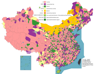
English: Map of China, shows counties, county-level cities, county-level districts, autonomous counties and banners, banners, etc.
日本語: 中国の地図は、郡、郡レベルの都市、郡レベルの地区、自治県とバナー、バナーなどを示しています。
Русский: Карта Китая, показывает уезды, города уездного уровня, уездные районы, автономные уезды и баннеры, баннеры и т. Д.
中文(简体):中国地图,显示县、县级市、县级区、自治县和旗、自治旗等。
中文(繁體):中國地圖,顯示縣、縣級市、縣級區、自治縣和旗、自治旗等。 |
||
| تاریخ |
|
||
| ماخذ |
Legend: English:
County
County-level city
County-level district
Autonomous county
Banner
Autonomous banner
No county-level division / Sub-prefectural level division
Special district
Special administrative region 中文(简体): 县
县级市
县级区
自治县
旗
自治旗
无县级/副地级
特区
特别行政区 |
||
| مصنف |
|
||
| اجازت (فائل کا دوبارہ استعمال) |
Map of China, administrative divisions: میں اس تخلیقی کام کے حقوق کا مالک ہوں اور اسے مندرجہ ذیل اجازت نامے کے تحت شائع کرتا ہوں:
|
اجازہ کاری
میں اس تخلیقی کام کے حقوق کا مالک ہوں اور اسے مندرجہ ذیل اجازت نامے کے تحت شائع کرتا ہوں:
This file is licensed under the Creative Commons Attribution-Share Alike 4.0 International license.
- آپ آزاد ہیں:
- شیئر کرنے – کام کو نقل، تقسیم یا منتقل کرنے کے لیے
- ریمکس کے لیے – کام منبطق کرنے کے لیے
- مندرجہ ذیل شرائط کے تحت:
- انتساب – آپ کو اس کام کا انتساب مصنف یا اجازت دہندہ کے بتائے گئے طریقہ کے مطابق دینا ہوگا (تاہم یہ انتساب اس طرح نہیں ہونا چاہیے کہ اسے دیکھ کر ایسا محسوس ہو کہ اصل مصنف یا اجازت دہندہ آپ کے یا آپ کے ذریعہ اس کام کے استعمال کرنے کے حامی ہیں)۔
- یکساں شراکت – اگر آپ اس کام میں کوئی تبدیلی یا ترمیم کرتے ہیں یا اس کام پر مبنی کچھ نیا بناتے ہیں تو اسے بھی آپ اسی یا اس جیسے کسی اجازت نامے کے تحت شائع کر سکتے ہیں۔

|
This map image could be re-created using vector graphics as an SVG file. This has several advantages; see Commons:Media for cleanup for more information. If an SVG form of this image is available, please upload it and afterwards replace this template with
{{vector version available|new image name}}.
It is recommended to name the SVG file “China county-level divisions and administrative divisions (PRoC claim).svg”—then the template Vector version available (or Vva) does not need the new image name parameter. |
| Annotations | This image is annotated: View the annotations at Commons |
فائل کا تاریخچہ
کسی خاص وقت یا تاریخ میں یہ فائل کیسی نظر آتی تھی، اسے دیکھنے کے لیے اس وقت/تاریخ پر کلک کریں۔
.png&dir=prev)
.png&offset=20220329005936)
.png&offset=&limit=20)
.png&offset=&limit=50)
.png&offset=&limit=100)
.png&offset=&limit=250)
.png&offset=&limit=500)
| تاریخ/وقت | تھمب نیل | ابعاد | صارف | تبصرہ | |
|---|---|---|---|---|---|
| رائج الوقت | 08:59، 1 اگست 2023ء | | 6,246 × 4,937 (1.54 MB) | Maanshen | Add Baiyang, update and fix Nanchang borders |
| 08:32، 1 اگست 2023ء |  | 6,246 × 4,937 (1.54 MB) | Maanshen | Update: Tsona County -> Tsona City, Mainling County -> Mainling City | |
| 12:30، 31 جولائی 2023ء |  | 6,246 × 4,937 (1.41 MB) | Baomi | ||
| 16:35، 16 جولائی 2023ء |  | 6,246 × 4,937 (1.59 MB) | Josemite | That old nine-dashed line is badly drawn | |
| 09:52، 17 فروری 2023ء |  | 6,246 × 4,937 (1.55 MB) | 孟天皓 | 修改香港区界 | |
| 23:06، 2 اگست 2022ء |  | 6,246 × 4,937 (1.55 MB) | Maanshen | Update disputed/claimed borders, white with stroke is not claimed and filled in color is claimed | |
| 00:08، 20 اپریل 2022ء |  | 6,246 × 4,937 (1.54 MB) | Maanshen | Fix borders between Ili's Kuytun, Huyanghe, and Karamay | |
| 23:41، 19 اپریل 2022ء |  | 6,246 × 4,937 (1.54 MB) | Maanshen | Fix colors again in Honghe counties | |
| 01:45، 31 مارچ 2022ء |  | 6,246 × 4,937 (1.54 MB) | Maanshen | Fix some colors | |
| 00:59، 29 مارچ 2022ء |  | 6,246 × 4,937 (1.54 MB) | Maanshen | Fix colors in Shanxi with Fenyang and Xiaoyi |
روابط
درج ذیل صفحہ اس فائل کو استعمال کر رہا ہے:
فائل کا عالمی استعمال
مندرجہ ذیل ویکیوں میں یہ فائل زیر استعمال ہے:
- ar.wikipedia.org پر استعمال
- ast.wikipedia.org پر استعمال
- az.wikipedia.org پر استعمال
- ca.wikipedia.org پر استعمال
- ce.wikipedia.org پر استعمال
- cs.wikipedia.org پر استعمال
- de.wikipedia.org پر استعمال
- en.wikipedia.org پر استعمال
- es.wikipedia.org پر استعمال
- fa.wikipedia.org پر استعمال
- fi.wikipedia.org پر استعمال
- fr.wikipedia.org پر استعمال
- id.wikipedia.org پر استعمال
- ja.wikipedia.org پر استعمال
- mk.wikipedia.org پر استعمال
- nl.wikipedia.org پر استعمال
- no.wikipedia.org پر استعمال
- pnb.wikipedia.org پر استعمال
- ru.wikipedia.org پر استعمال
- sv.wikipedia.org پر استعمال
- th.wikipedia.org پر استعمال
- tr.wikipedia.org پر استعمال
- uk.wikipedia.org پر استعمال
- vi.wikipedia.org پر استعمال
- www.wikidata.org پر استعمال
- zh.wikipedia.org پر استعمال
اس فائل کا مزید عالمی استعمال دیکھیے۔
.png)
.png)