فائل:China prefectural-level divisions and administrative divisions (PRoC claim).png

اس نمائش کا حجم: 759 × 600 پکسلز۔ دیگر تصمیمات: 304 × 240 پکسلز | 607 × 480 پکسلز | 972 × 768 پکسلز | 1,280 × 1,012 پکسلز | 2,560 × 2,023 پکسلز | 6,246 × 4,937 پکسلز۔
اصل فائل (6,246 × 4,937 پکسل، فائل کا حجم: 987 کلوبائٹ، MIME قسم: image/png)


|
The boundaries on this map show the de facto situation. This is just one of several different views on the subject (see COM:NPOV). |

|
This image is expected to always be the most recent one. Feel free to update it when needed.
|

|
This file may be updated to reflect new information. If you wish to use a specific version of the file without new updates being mirrored, please upload the required version as a separate file. |
خلاصہ
| وضاحت |
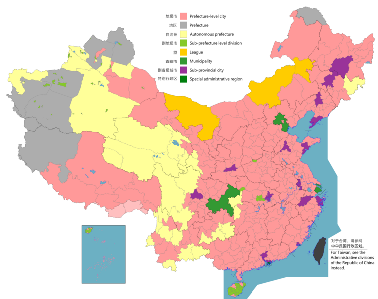
English: Map of China, shows provinces, prefecture-level divisions, etc.
日本語: 中国の地図、州、県レベルの区分などを示しています。
Русский: Карта Китая, показывает провинции, подразделения на уровне префектур и т. Д.
Монгол: Хятад улсын газрын зураг, мужууд, мужийн түвшний хэлтэс гэх мэтийг харуулсан.
中文(简体):中华人民共和国地图,显示省、地级区划等。(包含未实际控制之疆域)
中文(繁體):中華人民共和國地圖,顯示省、地級區劃等。 (包含未實際控制之疆域) |
||
| Map legend |
English:
Prefecture-level city
Prefecture
Autonomous prefecture
Sub prefecture-level division
League
Municipality
Sub-provincial city
Special administrative region 图例: 中文(简体):
地级市
地区
自治州
副地级市
盟
直辖市
副省级市
特别行政区 圖例: 中文(繁體): 地級市
地區
自治州
副地級市
盟
直轄市
副省級市
特別行政區 |
||
| تاریخ |
English: File uploaded: November 6, 2021
English: Original uploaded: September 12, 2011
Latest update: 07:09, 17 November 2023 中文(简体):原始上传时间2011年9月12日
中文(繁體):文件上传时间2021年11月6日
中文(繁體):原始上傳時間2011年9月12日 |
||
| ماخذ |
English: Source appearances: 中文(简体):来源于: 中文(繁體):來源於:
[]
|
||
| خالق |
|
||
| اجازت (فائل کا دوبارہ استعمال) |
English: Map of China, administrative divisions: 中文(简体):中国地图,行政区划 中文(繁體):中國地圖,行政區劃 میں اس تخلیقی کام کے حقوق کا مالک ہوں اور اسے مندرجہ ذیل اجازت نامے کے تحت شائع کرتا ہوں:
|
||
| Geotemporal data | |||
| تاریخی عکاسی | as of February 4, 2021 | ||
| Spatial reference system | Custom | ||
| Georeferencing | |||
| دوسرے نسخے |
English: Other languages: 中文(简体):其他语言: 中文(繁體):其他語言:
[]
Derivative works on these files: |
||


.png)
_sl.png)
.png)
اجازہ کاری
میں اس تخلیقی کام کے حقوق کا مالک ہوں اور اسے مندرجہ ذیل اجازت نامے کے تحت شائع کرتا ہوں:
This file is licensed under the Creative Commons Attribution-Share Alike 4.0 International license.
- آپ آزاد ہیں:
- شیئر کرنے – کام کو نقل، تقسیم یا منتقل کرنے کے لیے
- ریمکس کے لیے – کام منبطق کرنے کے لیے
- مندرجہ ذیل شرائط کے تحت:
- انتساب – آپ کو اس کام کا انتساب مصنف یا اجازت دہندہ کے بتائے گئے طریقہ کے مطابق دینا ہوگا (تاہم یہ انتساب اس طرح نہیں ہونا چاہیے کہ اسے دیکھ کر ایسا محسوس ہو کہ اصل مصنف یا اجازت دہندہ آپ کے یا آپ کے ذریعہ اس کام کے استعمال کرنے کے حامی ہیں)۔
- یکساں شراکت – اگر آپ اس کام میں کوئی تبدیلی یا ترمیم کرتے ہیں یا اس کام پر مبنی کچھ نیا بناتے ہیں تو اسے بھی آپ اسی یا اس جیسے کسی اجازت نامے کے تحت شائع کر سکتے ہیں۔

|
This locator map image could be re-created using vector graphics as an SVG file. This has several advantages; see Commons:Media for cleanup for more information. If an SVG form of this image is available, please upload it and afterwards replace this template with
{{vector version available|new image name}}.
It is recommended to name the SVG file “China prefectural-level divisions and administrative divisions (PRoC claim).svg”—then the template Vector version available (or Vva) does not need the new image name parameter. |
|
|
This map image could be re-created using vector graphics as an SVG file. This has several advantages; see Commons:Media for cleanup for more information. If an SVG form of this image is available, please upload it and afterwards replace this template with
{{vector version available|new image name}}.
It is recommended to name the SVG file “China prefectural-level divisions and administrative divisions (PRoC claim).svg”—then the template Vector version available (or Vva) does not need the new image name parameter. |
| Annotations | This image is annotated: View the annotations at Commons |
فائل کا تاریخچہ
کسی خاص وقت یا تاریخ میں یہ فائل کیسی نظر آتی تھی، اسے دیکھنے کے لیے اس وقت/تاریخ پر کلک کریں۔
.png&dir=prev)
.png&offset=20220128000854)
.png&offset=&limit=20)
.png&offset=&limit=50)
.png&offset=&limit=100)
.png&offset=&limit=250)
.png&offset=&limit=500)
| تاریخ/وقت | تھمب نیل | ابعاد | صارف | تبصرہ | |
|---|---|---|---|---|---|
| رائج الوقت | 02:26، 11 اگست 2023ء | | 6,246 × 4,937 (987 کلوبائٹ) | Vikarna | 州→地区 & 副地级划分→副地级市 |
| 08:59، 1 اگست 2023ء |  | 6,246 × 4,937 (987 کلوبائٹ) | Maanshen | Add Baiyang county-level city | |
| 09:50، 1 دسمبر 2022ء |  | 6,246 × 4,937 (987 کلوبائٹ) | Maanshen | Re-added disputed borders from the third version and removed the nine-dash line to prevent future bans to maps | |
| 05:28، 23 نومبر 2022ء |  | 6,246 × 4,937 (951 کلوبائٹ) | Vikarna | municipality 市政府→直辖市 | |
| 05:10، 23 نومبر 2022ء |  | 6,246 × 4,937 (986 کلوبائٹ) | Vikarna | League 联盟→盟 | |
| 23:06، 2 اگست 2022ء |  | 6,246 × 4,937 (992 کلوبائٹ) | Maanshen | Update disputed/claimed borders, white with stroke is not claimed and filled in color is claimed | |
| 00:08، 20 اپریل 2022ء |  | 6,246 × 4,937 (975 کلوبائٹ) | Maanshen | Fix borders between Ili's Kuytun, Huyanghe, and Karamay | |
| 03:51، 1 مارچ 2022ء |  | 6,246 × 4,937 (975 کلوبائٹ) | Maanshen | Update Shanghai land reclamation | |
| 08:26، 28 جنوری 2022ء |  | 6,246 × 4,937 (975 کلوبائٹ) | Maanshen | Fix Changchun-Siping border | |
| 00:08، 28 جنوری 2022ء |  | 6,246 × 4,937 (975 کلوبائٹ) | Maanshen | Add parts of Tiemenguan |
روابط
درج ذیل 2 صفحات اس فائل کو استعمال کر رہے ہیں:
فائل کا عالمی استعمال
مندرجہ ذیل ویکیوں میں یہ فائل زیر استعمال ہے:
- ast.wikipedia.org پر استعمال
- bg.wikipedia.org پر استعمال
- cs.wikipedia.org پر استعمال
- en.wikipedia.org پر استعمال
- es.wikipedia.org پر استعمال
- fa.wikipedia.org پر استعمال
- fi.wikipedia.org پر استعمال
- fr.wikipedia.org پر استعمال
- hu.wiktionary.org پر استعمال
- id.wikipedia.org پر استعمال
- incubator.wikimedia.org پر استعمال
- ja.wikipedia.org پر استعمال
- pt.wikipedia.org پر استعمال
- ru.wikipedia.org پر استعمال
- sh.wikipedia.org پر استعمال
- si.wikipedia.org پر استعمال
- sv.wikipedia.org پر استعمال
- th.wikipedia.org پر استعمال
- tr.wikipedia.org پر استعمال
- vi.wikipedia.org پر استعمال
- www.wikidata.org پر استعمال
- wuu.wikipedia.org پر استعمال
- zh-yue.wikipedia.org پر استعمال
- zh.wikipedia.org پر استعمال
اس فائل کا مزید عالمی استعمال دیکھیے۔
.png)
.png)