فائل:Concord 1936.jpg

اس نمائش کا حجم: 800 × 568 پکسلز۔ دیگر تصمیمات: 320 × 227 پکسلز | 640 × 455 پکسلز | 846 × 601 پکسلز۔
اصل فائل (846 × 601 پکسل، فائل کا حجم: 133 کلوبائٹ، MIME قسم: image/jpeg)
خلاصہ
|
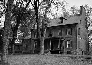
This is an image of a place or building that is listed on the National Register of Historic Places in the United States of America. Its reference number is 82004681. |
| تفصیل |
English: Concord: Historic American Buildings Survey John O. Brostrup, Photographer April 27, 1936 9:10 A.M. VIEW FROM SOUTHEAST (front) HABS MD,17-SEPL.V,1-1 |
| تاریخ | |
| ماخذ | Library of Congress Prints & Photographs Division |
| مصنف | Historic American Buildings Survey / Historic American Engineering Record |
| Object location | | View this and other nearby images on: OpenStreetMap |
|---|
اجازہ کاری

|
This file comes from the Historic American Buildings Survey (HABS), Historic American Engineering Record (HAER) or Historic American Landscapes Survey (HALS). These are programs of the National Park Service established for the purpose of documenting historic places. Records consist of measured drawings, archival photographs, and written reports.
This tag does not indicate the copyright status of the attached work. A normal copyright tag is still required. See Commons:Licensing. |
| This image or media file contains material based on a work of a National Park Service employee, created as part of that person's official duties. As a work of the U.S. federal government, such work is in the public domain in the United States. See the NPS website and NPS copyright policy for more information. |
اولین اپلوڈ کا نوشتہ
Transferred from en.wikipedia to Commons by Sreejithk2000 using CommonsHelper.
فائل کی تفصیلات کا اصل صفحہ یہاں تھا۔ درج ذیل تمام صارفین en.wikipedia کے ہیں۔
- 2009-07-09 10:05 Pubdog 846×601× (136573 bytes) upload cropped pic
- 2009-01-01 23:36 Pubdog 1024×734× (198214 bytes) {{Information |Description=Concord: Historic American Buildings Survey John O. Brostrup, Photographer April 27, 1936 9:10 A.M. VIEW FROM SOUTHEAST (front) HABS MD,17-SEPL.V,1-1 |Source=Library of Congress Prints & Photographs Division |Date= Jan 1, 2009
فائل کا تاریخچہ
کسی خاص وقت یا تاریخ میں یہ فائل کیسی نظر آتی تھی، اسے دیکھنے کے لیے اس وقت/تاریخ پر کلک کریں۔
| تاریخ/وقت | تھمب نیل | ابعاد | صارف | تبصرہ | |
|---|---|---|---|---|---|
| رائج الوقت | 13:24، 2 جون 2010ء | | 846 × 601 (133 کلوبائٹ) | File Upload Bot (Magnus Manske) | {{BotMoveToCommons|en.wikipedia|year={{subst:CURRENTYEAR}}|month={{subst:CURRENTMONTHNAME}}|day={{subst:CURRENTDAY}}}} {{Information |Description={{en|Concord: Historic American Buildings Survey John O. Brostrup, Photographer April 27, 1936 9:10 A.M. VIE |
روابط
درج ذیل صفحہ اس فائل کو استعمال کر رہا ہے:
فائل کا عالمی استعمال
مندرجہ ذیل ویکیوں میں یہ فائل زیر استعمال ہے:
- en.wikipedia.org پر استعمال
- sr.wikipedia.org پر استعمال
- www.wikidata.org پر استعمال