فائل:Conical mound in trough on Mars' north pole.jpg

اصل فائل (1,734 × 1,188 پکسل، فائل کا حجم: 1.23 MB، MIME قسم: image/jpeg)
خلاصہ
| تفصیل |
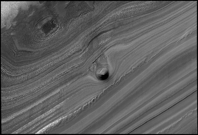
English: This striking image of a mound within the area of a trough cutting into Mars' north polar layered deposits was taken by the High Resolution Imaging Science Experiment (HiRISE) camera on NASA's Mars Reconnaissance Orbiter on September 2, 2008.
The north polar layered deposits are a stack of discernible layers that are rich in water-ice. The stack is up to several miles thick. Each layer is thought to contain information about the climate that existed when it was deposited. If true, the stack could represent a record of how climate has varied on Mars in the recent past. The internal layers are exposed in troughs and scarps where erosion has cut into the stack. The trough shown in this image contains a 1,640-foot thick section of the layering. A conical mound partway down the slope stands approximately 130 feet high. One possible explanation for this unusual mound is that it may be the remnant of a buried impact crater now being exhumed. As the north polar layered deposits accumulated, impacts occurred throughout their surface area, then the impact craters were buried by additional ice. These buried craters are generally inaccessible, but, in a few locations, erosion that forms a trough (like this one) can uncover these buried structures. For reasons poorly understood, the ice beneath the site of the crater is more resistant to this erosion, so when material is removed by erosion the ice beneath the old impact site remains, forming this isolated hill. |
| تاریخ | |
| ماخذ | NASA website; description,[1] high resolution image.[2] |
| مصنف | NASA/JPL-Caltech/University of Arizona |
![[2]](http://www.nasa.gov/images/content/283447main_PIA11231_full.jpg)
| This is a retouched picture, which means that it has been digitally altered from its original version. Modifications: Rotated source image.
|
اجازہ کاری
| This file is in the public domain in the United States because it was solely created by NASA. NASA copyright policy states that "NASA material is not protected by copyright unless noted". (See Template:PD-USGov, NASA copyright policy page or JPL Image Use Policy.) | ||
 |
Warnings:
|
فائل کا تاریخچہ
کسی خاص وقت یا تاریخ میں یہ فائل کیسی نظر آتی تھی، اسے دیکھنے کے لیے اس وقت/تاریخ پر کلک کریں۔
| تاریخ/وقت | تھمب نیل | ابعاد | صارف | تبصرہ | |
|---|---|---|---|---|---|
| رائج الوقت | 11:31، 28 اکتوبر 2008ء | | 1,734 × 1,188 (1.23 MB) | Elipongo | {{Information |Description={{en|1=This striking image of a mound within the area of a trough cutting into Mars' north polar layered deposits was taken by the High Resolution Imaging Science Experiment (HiRISE) camera on NASA's [[Mars Reconnaissance Or |
روابط
درج ذیل صفحہ اس فائل کو استعمال کر رہا ہے:
فائل کا عالمی استعمال
مندرجہ ذیل ویکیوں میں یہ فائل زیر استعمال ہے:
- ca.wikipedia.org پر استعمال
- de.wikipedia.org پر استعمال
- en.wikipedia.org پر استعمال
- es.wikipedia.org پر استعمال
- lb.wikipedia.org پر استعمال
- pnb.wikipedia.org پر استعمال
- tr.wikipedia.org پر استعمال
- zh.wikipedia.org پر استعمال