فائل:Democratic Republic of Georgia map.jpg
اس نمائش کا حجم: 800 × 561 پکسلز۔ دیگر تصمیمات: 320 × 224 پکسلز | 640 × 448 پکسلز | 1,024 × 718 پکسلز | 1,213 × 850 پکسلز۔
اصل فائل (1,213 × 850 پکسل، فائل کا حجم: 442 کلوبائٹ، MIME قسم: image/jpeg)

|
This history map image could be re-created using vector graphics as an SVG file. This has several advantages; see Commons:Media for cleanup for more information. If an SVG form of this image is available, please upload it and afterwards replace this template with
{{vector version available|new image name}}.
It is recommended to name the SVG file “Democratic Republic of Georgia map.svg”—then the template Vector version available (or Vva) does not need the new image name parameter. |


خلاصہ
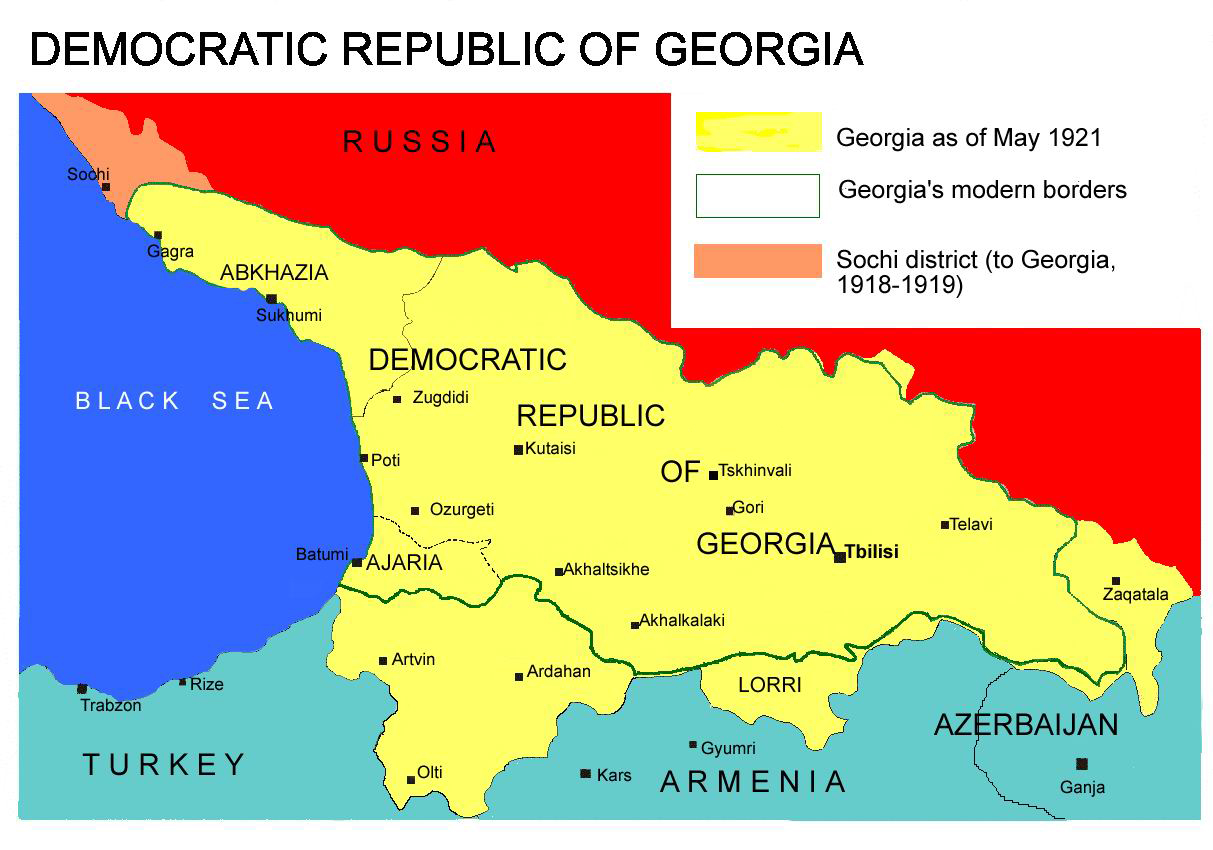
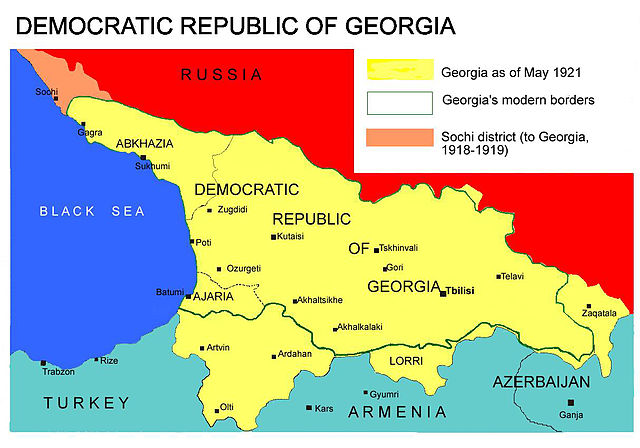
Democratic Republic of Georgia map, 1918-1921
Source: english wikipedia
Uploaded by user:Kober
اجازہ کاری
| میں اس تخلیقی کام کے حقوق کا مالک ہوں اور اسے دائرہ عام میں شائع کرتا ہوں جس کا اطلاق عالمی سطح پر ہوتا ہے۔ بعض ملکوں میں یہ قانونی طور پر شاید ممکن نہ ہو؛ اگر ایسا ہے تو: میں ہر ایک کو کسی بھی مقصد کے لیے بغیر کسی شرط کے اس تصویر کے استعمال کا حق تفویض کرتا/کرتی ہوں، بجز اس صورت کے جس میں کوئی قانونی رکاوٹ موجود ہو۔ |
فائل کا تاریخچہ
کسی خاص وقت یا تاریخ میں یہ فائل کیسی نظر آتی تھی، اسے دیکھنے کے لیے اس وقت/تاریخ پر کلک کریں۔
| تاریخ/وقت | تھمب نیل | ابعاد | صارف | تبصرہ | |
|---|---|---|---|---|---|
| رائج الوقت | 13:26، 7 اپریل 2013ء | | 1,213 × 850 (442 کلوبائٹ) | Giorgi Balakhadze | At that time (May, 1921 year) there was no South Ossetia, it was created in 1922. |
| 13:21، 7 اپریل 2013ء |  | 1,213 × 850 (442 کلوبائٹ) | Giorgi Balakhadze | Reverted to version as of 13:08, 7 April 2013 | |
| 13:15، 7 اپریل 2013ء |  | 1,213 × 850 (442 کلوبائٹ) | Giorgi Balakhadze | At that time (1921 year) there was no South Ossetia, it was created 1922. | |
| 13:08، 7 اپریل 2013ء |  | 1,213 × 850 (442 کلوبائٹ) | Giorgi Balakhadze | At that time (1921 year) there was no South Osetia. | |
| 16:46، 26 دسمبر 2005ء |  | 1,213 × 850 (111 کلوبائٹ) | Hardscarf | Democratic Republic of Georgia map, 1918-1921 Source: [http://en.wikipedia.org/wiki/Image:Democratic_Republic_of_Georgia_map.jpg english wikipedia] Uploaded by [http://en.wikipedia.org/wiki/User:Kober user:Kober] Category:Historical maps of Georgia |
روابط
درج ذیل صفحہ اس فائل کو استعمال کر رہا ہے:
فائل کا عالمی استعمال
مندرجہ ذیل ویکیوں میں یہ فائل زیر استعمال ہے:
- bg.wikipedia.org پر استعمال
- bn.wikipedia.org پر استعمال
- da.wikipedia.org پر استعمال
- de.wikipedia.org پر استعمال
- en.wikipedia.org پر استعمال
- en.wikibooks.org پر استعمال
- fa.wikipedia.org پر استعمال
- id.wikipedia.org پر استعمال
- ka.wikipedia.org پر استعمال
- lt.wikipedia.org پر استعمال
- pl.wikipedia.org پر استعمال
- pnb.wikipedia.org پر استعمال
- pt.wikipedia.org پر استعمال
- ru.wikipedia.org پر استعمال
- sk.wikipedia.org پر استعمال
- sr.wikipedia.org پر استعمال
- tr.wikipedia.org پر استعمال
- uk.wikipedia.org پر استعمال
- zh.wikipedia.org پر استعمال