فائل:Early Localization Native Americans USA.jpg
اس نمائش کا حجم: 800 × 514 پکسلز۔ دیگر تصمیمات: 320 × 206 پکسلز | 640 × 412 پکسلز | 1,024 × 659 پکسلز | 1,280 × 823 پکسلز | 2,560 × 1,646 پکسلز | 3,850 × 2,476 پکسلز۔
اصل فائل (3,850 × 2,476 پکسل، فائل کا حجم: 2.13 MB، MIME قسم: image/jpeg)
خلاصہ
| تفصیل |
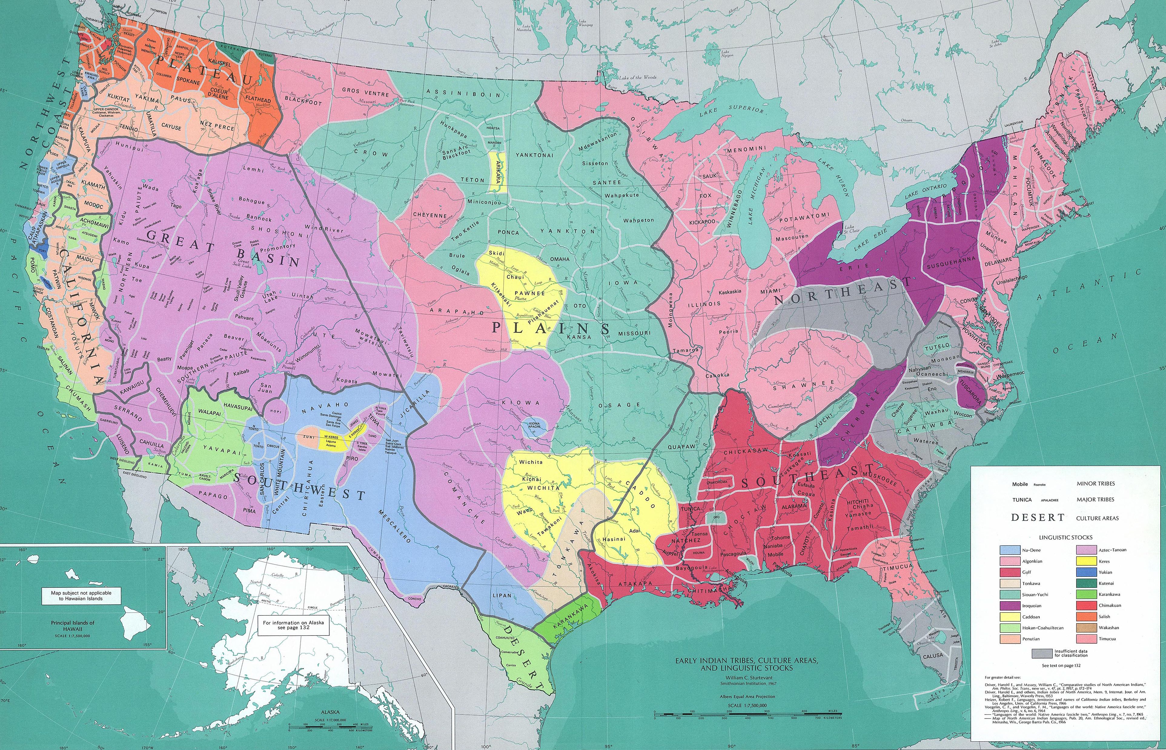
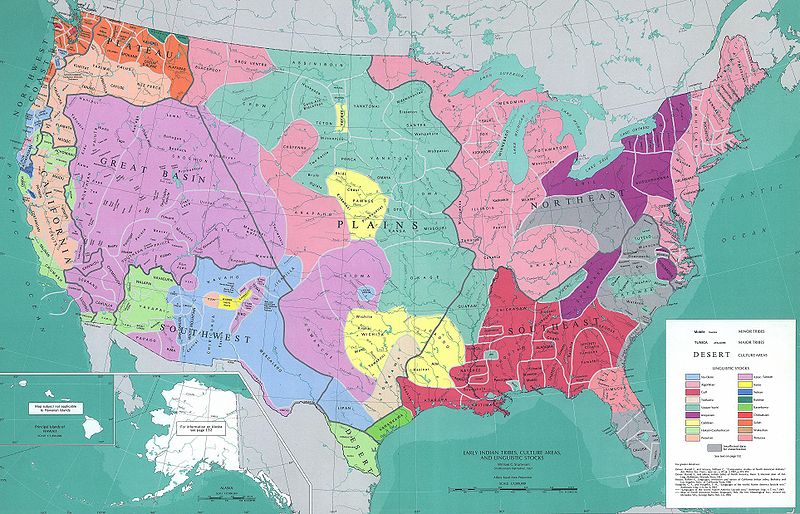
English: Map reconstituting the geographic culture areas of the early Native American tribes and the different Amerindian languages that were spoken in the USA.
Español: Mapa que reconstituye de forma geográfica las zonas culturales de las primeras tribus indígenas de los Estados Unidos y los varios idiomas ameríndios que se hablaban en ese país
Português: Mapa reconstituindo as áreas geográficas da cultura das primeiras tribos indígenas americanas e as diferentes línguas ameríndias faladas nos Estados Unidos. |
|||
| تاریخ | ||||
| ماخذ | 1967 USGS map. | |||
| مصنف | William C. Sturtevant, Smithsonian Institute, 1967 | |||
| اجازت (فائل کا دوبارہ استعمال) |
|
|||
| دوسرے نسخے |
Derivative works of this file: Early Localization Native Americans NY.jpg Early Indian Languages USA.jpg Derivative works of this file: Early Localization Native Americans USA-nw.png Early Indian Languages of the USA (NW) |
فائل کا تاریخچہ
کسی خاص وقت یا تاریخ میں یہ فائل کیسی نظر آتی تھی، اسے دیکھنے کے لیے اس وقت/تاریخ پر کلک کریں۔
| تاریخ/وقت | تھمب نیل | ابعاد | صارف | تبصرہ | |
|---|---|---|---|---|---|
| رائج الوقت | 04:57، 30 جنوری 2009ء | | 3,850 × 2,476 (2.13 MB) | Hrystiv | {{Information |Description=Early Indian Languages of the USA |Source=1970 USGS map. |Date=1970 |Author=USGS |Permission={{PD-USGov-USGS}} |other_versions=Early Indian Languages USA.jpg }} Category:Maps of Native American languages <!--{{ImageUpload|b |
روابط
درج ذیل صفحہ اس فائل کو استعمال کر رہا ہے:
فائل کا عالمی استعمال
مندرجہ ذیل ویکیوں میں یہ فائل زیر استعمال ہے:
- bg.wikipedia.org پر استعمال
- bs.wikipedia.org پر استعمال
- ca.wikipedia.org پر استعمال
- cs.wikipedia.org پر استعمال
- de.wikipedia.org پر استعمال
- en.wikipedia.org پر استعمال
- Native Americans in the United States
- Manifest destiny
- Classification of the Indigenous peoples of the Americas
- Plains Indians
- Classification of the Indigenous languages of the Americas
- Wikipedia:Reference desk/Archives/Humanities/2012 July 4
- Native American cultures in the United States
- Native American genocide in the United States
- en.wikiquote.org پر استعمال
- es.wikipedia.org پر استعمال
- fi.wikibooks.org پر استعمال
- fr.wikipedia.org پر استعمال
- hi.wikipedia.org پر استعمال
- kn.wikipedia.org پر استعمال
- mwl.wikipedia.org پر استعمال
- nl.wikipedia.org پر استعمال
- pnb.wikipedia.org پر استعمال
- pt.wikipedia.org پر استعمال
- ru.wikipedia.org پر استعمال
- uk.wikipedia.org پر استعمال
- www.wikidata.org پر استعمال