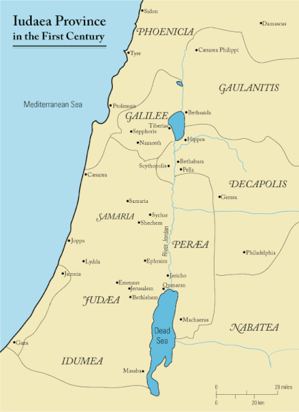
فائل:First century Iudaea province.gif

اس نمائش کا حجم: 435 × 599 پکسلز۔ دیگر تصمیمات: 174 × 240 پکسلز | 575 × 792 پکسلز۔
اصل فائل (575 × 792 پکسل، فائل کا حجم: 31 کلوبائٹ، MIME قسم: image/gif)
فائل کا تاریخچہ
کسی خاص وقت یا تاریخ میں یہ فائل کیسی نظر آتی تھی، اسے دیکھنے کے لیے اس وقت/تاریخ پر کلک کریں۔
| تاریخ/وقت | تھمب نیل | ابعاد | صارف | تبصرہ | |
|---|---|---|---|---|---|
| رائج الوقت | 11:47، 18 ستمبر 2011ء |  | 575 × 792 (31 کلوبائٹ) | Onceinawhile | Removed region-name "Philistia", as incorrect |
| 14:05، 13 ستمبر 2007ء |  | 575 × 792 (32 کلوبائٹ) | Liftarn | {{SVG|map}} {{Information |Description=This is a map of first century en:Iudaea Province that I created using Illustrator CS2. I traced [http://commons.wikimedia.org/wiki/Image:Map_of_administrative_regions_in_Israel.png this] image for the general g | |
| 00:29، 30 اپریل 2006ء |  | 575 × 792 (32 کلوبائٹ) | Duende~commonswiki | http://en.wikipedia.org/wiki/Image:First_century_palestine.gif |
روابط
درج ذیل 31 صفحات اس فائل کو استعمال کر رہے ہیں:
- اریحا
- اماؤس
- بحیرہ طبریہ
- بیت المقدس
- بیت برہ
- بیت صیدا
- بیت عنیاہ (بائبل کا گاؤں)
- بیت فگے
- بیت لحم
- جبل زیتون
- جرش
- حوض بیت حسدا
- خرازین
- رحلت مصر
- سکم، مقام بائبل
- عنین
- قانا
- قیصریہ بحری
- قیصریہ فلپی
- نائین
- ناصرہ
- پیریہ
- کفر نحوم
- کوہ تجلی
- گبتھا
- گتسمنی
- گلگتا
- گنیسرت
- یروشلم
- یہودا (رومی صوبہ)
- سانچہ:یسوع مسیح سے متعلقہ عہد نامہ جدید کے مقامات
فائل کا عالمی استعمال
مندرجہ ذیل ویکیوں میں یہ فائل زیر استعمال ہے:
- af.wikipedia.org پر استعمال
- ar.wikipedia.org پر استعمال
- azb.wikipedia.org پر استعمال
- be-tarask.wikipedia.org پر استعمال
- be.wikipedia.org پر استعمال
- bg.wikipedia.org پر استعمال
- bn.wikipedia.org پر استعمال
- br.wikipedia.org پر استعمال
- ca.wikipedia.org پر استعمال
- co.wikipedia.org پر استعمال
- cs.wikipedia.org پر استعمال
- cy.wikipedia.org پر استعمال
- da.wikipedia.org پر استعمال
- de.wikipedia.org پر استعمال
- el.wikipedia.org پر استعمال
- en.wikipedia.org پر استعمال
- History of Jordan
- Titus
- Berenice (daughter of Herod Agrippa)
- Parable of the Good Samaritan
- Historicity of Jesus
- Historical Jesus
- Life of Jesus
- Judaea (Roman province)
- Matthew 4:25
- Perea
- New Testament places associated with Jesus
- User:Andrew c/Jesus
- Marcus Antonius Julianus
- List of revolutions and rebellions
- User:Pedia-I/ Jesus
- Ventidius Cumanus
- History of the Jews in Jordan
- Early Christianity
- Far, Far Away on Judea's Plains
- Kosher Jesus
اس فائل کا مزید عالمی استعمال دیکھیے۔


