فائل:Iles glorieuses 76.jpg

اس نمائش کا حجم: 800 × 491 پکسلز۔ دیگر تصمیمات: 320 × 196 پکسلز | 640 × 393 پکسلز | 896 × 550 پکسلز۔
اصل فائل (896 × 550 پکسل، فائل کا حجم: 102 کلوبائٹ، MIME قسم: image/jpeg)
خلاصہ
| تفصیل |
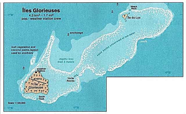
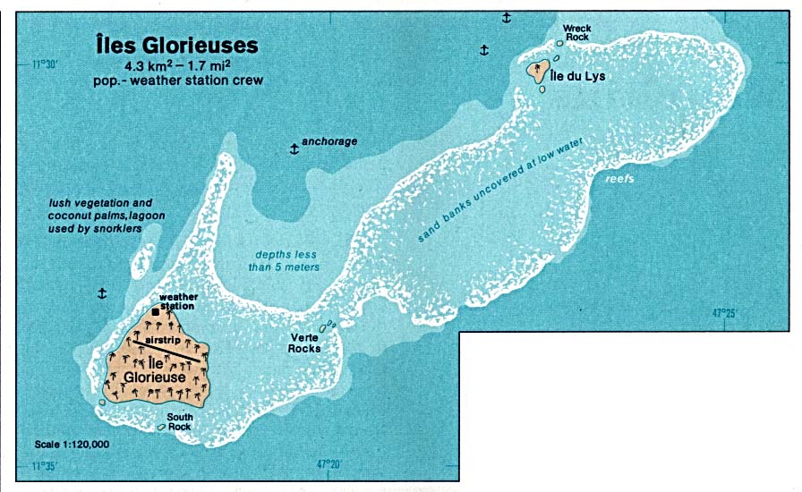
Deutsch: Karte der Îles Glorieuses im Indischen Ozean
English: Map of Glorioso Island in the Indian Ocean
Français : Carte d’îles Glorieuses dans l’océan Indien |
| تاریخ | |
| ماخذ | http://www.lib.utexas.edu/maps/islands_oceans_poles/iles_glorieuses_76.jpg |
| مصنف | Taken from Perry-Castañeda Library (PCL), originally from CIA Indian Ocean Atlas |
| اجازت (فائل کا دوبارہ استعمال) |
PD, see licensing |
اجازہ کاری
| This image is a work of a Central Intelligence Agency employee, taken or made as part of that person's official duties. As a Work of the United States Government, this image or media is in the public domain in the United States.
|

|
فائل کا تاریخچہ
کسی خاص وقت یا تاریخ میں یہ فائل کیسی نظر آتی تھی، اسے دیکھنے کے لیے اس وقت/تاریخ پر کلک کریں۔
| تاریخ/وقت | تھمب نیل | ابعاد | صارف | تبصرہ | |
|---|---|---|---|---|---|
| رائج الوقت | 05:36، 3 فروری 2005ء | | 896 × 550 (102 کلوبائٹ) | Dysprosia~commonswiki | {{PD-PCL|http://www.lib.utexas.edu/maps/islands_oceans_poles/iles_glorieuses_76.jpg}} |
روابط
درج ذیل صفحہ اس فائل کو استعمال کر رہا ہے:
فائل کا عالمی استعمال
مندرجہ ذیل ویکیوں میں یہ فائل زیر استعمال ہے:
- ar.wikipedia.org پر استعمال
- az.wikipedia.org پر استعمال
- be.wikipedia.org پر استعمال
- cs.wikipedia.org پر استعمال
- el.wikipedia.org پر استعمال
- en.wikipedia.org پر استعمال
- eo.wikipedia.org پر استعمال
- es.wikipedia.org پر استعمال
- fa.wikipedia.org پر استعمال
- fr.wikipedia.org پر استعمال
- gl.wikipedia.org پر استعمال
- hi.wikipedia.org پر استعمال
- hr.wikipedia.org پر استعمال
- hu.wikipedia.org پر استعمال
- id.wikipedia.org پر استعمال
- ja.wikipedia.org پر استعمال
- ka.wikipedia.org پر استعمال
- lij.wikipedia.org پر استعمال
- mk.wikipedia.org پر استعمال
- nl.wikipedia.org پر استعمال
- no.wikipedia.org پر استعمال
- pl.wikipedia.org پر استعمال
- ru.wikipedia.org پر استعمال
- sh.wikipedia.org پر استعمال
- sr.wikipedia.org پر استعمال
- sv.wikipedia.org پر استعمال
- uk.wikipedia.org پر استعمال
- vi.wikipedia.org پر استعمال
- zh.wikipedia.org پر استعمال