فائل:India Kerala locator map.svg

اصل فائل (ایس وی جی فائل، ابعاد 1,574 × 1,738 پکسل، فائل کا حجم: 836 کلوبائٹ)
| عنوان |
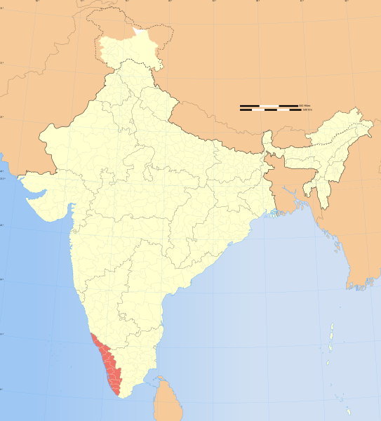
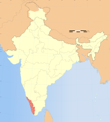
Kerala locator map |
|||||||||
| وضاحت |
Locator map of the state of Kerala, India with district boundaries. |
|||||||||
| Map legend |
 |
|||||||||
| تاریخ | ||||||||||
| ماخذ |
ذاتی کام |
|||||||||
| خالق |
|
|||||||||
| اجازت (فائل کا دوبارہ استعمال) |
میں اس تخلیقی کام کے حقوق کا مالک ہوں اور اسے مندرجہ ذیل اجازت نامے کے تحت شائع کرتا ہوں: اس ملف کا لائسنس Creative Commons Attribution-Share Alike 3.0 Unported کے تحط ہے۔
|
|||||||||
| Geotemporal data | ||||||||||
| تاریخی عکاسی | نصف آخر صدی 20 و صدی 21 | |||||||||
| Spatial reference system | conic | |||||||||
| Bounding box |
|
|||||||||
| Archival data | ||||||||||
| ملاحظات | Part of WikiProject India Maps | |||||||||
| دوسرے نسخے |
|
|||||||||
| SVG genesis | This W3C-invalid locator map was created with Adobe Illustrator. |
|||||||||


Notes
Depiction of India's borders
- The territorial boundaries of India are shown as per the actual ground situation in accordance with international practices followed by the United Nations ([2], [3]) and the National Geographic Society ([4], [5])
- This map is meant to be for illustrative purpose only and is not authenticated by official government sources. Please check the list of sources and references used to create the map for a measure of accuracy and verifiability.
- The usage of these maps in India, Pakistan and China are governed by different laws that restrict depictions of boundaries other than what is officially recognized by the state. Please check local laws and modify the map accordingly before use.
Explanation of disputed boundaries


- Boundary of Indian claim : The territory India claims is legally theirs, but the claim is disputed by China and Pakistan.
- Line of Control/Line of Conflict : The de facto administrative boundary recognised by the international community. This UN ceasefire line is considered as a temporary solution to an ongoing conflict since the departure of the British Raj.
Borders of disputed regions
The depicted extent of the former territory of the British Indian Empire, succeeded by Republic of India, may not be accepted by few countries as legal due to ongoing border disputes:
- The northern Himalayan region of the disputed territory Indian-administered Kashmir is claimed by India including (Pakistan-administered Kashmir) and the Chinese-occupied territory of (Ladakh plateau). Since 1972, it is divided between all three countries. See also Line of Control and Line of Actual Control.
- Siachen glacier (shown white) is an actively contested region between India and Pakistan. Since 1984, the region is under Indian control.
- The northeastern territory of Arunachal Pradesh is almost entirely claimed by China as part of its Tibetan territory.
- Minor areas of eastern Kashmir's Ladakh division, Himachal Pradesh and Uttarakhand on the Chinese frontier are claimed by China. These areas are under Indian control.
- A small area of Uttarakhand adjoining the Nepal border along the Sarda river is disputed between the two countries.
For a detailed map of all disputed regions in South Asia, see Image:India disputed areas map.svg
Internal borders
The borders of the state of Meghalaya, Assam and Arunachal Pradesh are shown as interpreted from the North-Eastern Areas (Reorganisation) Act, 1971, but has yet to be verified.
Territorial waters
The limit of the territorial waters of India extends to twelve nautical miles measured from the appropriate baseline. See this for more information.
فائل کا تاریخچہ
کسی خاص وقت یا تاریخ میں یہ فائل کیسی نظر آتی تھی، اسے دیکھنے کے لیے اس وقت/تاریخ پر کلک کریں۔
| تاریخ/وقت | تھمب نیل | ابعاد | صارف | تبصرہ | |
|---|---|---|---|---|---|
| رائج الوقت | 06:53، 29 دسمبر 2008ء | | 1,574 × 1,738 (836 کلوبائٹ) | Planemad | {{Information |Description= |Source= |Date= |Author= |Permission= |other_versions= }} |
| 17:22، 6 اگست 2006ء |  | 1,639 × 1,852 (750 کلوبائٹ) | Planemad | {{WikiProject_India_Maps |Title=Kerala locator map |Description=Locator map of the state of Kerala, India with district boundaries. |Source=. |Date=August 6 2006 |Author=w:user:Nichalpw:user:Planemad |Thumbdir=CHANGE }} |
روابط
درج ذیل صفحہ اس فائل کو استعمال کر رہا ہے:
فائل کا عالمی استعمال
مندرجہ ذیل ویکیوں میں یہ فائل زیر استعمال ہے:
- azb.wikipedia.org پر استعمال
- ba.wikipedia.org پر استعمال
- be.wikipedia.org پر استعمال
- bg.wikipedia.org پر استعمال
- br.wikipedia.org پر استعمال
- cdo.wikipedia.org پر استعمال
- ceb.wikipedia.org پر استعمال
- cy.wikipedia.org پر استعمال
- dv.wikipedia.org پر استعمال
- en.wikipedia.org پر استعمال
- User:Sujit
- User:Adnat
- Category:Kerala Wikipedians
- User:It afzal
- User:Kpillai
- User:Gingerjoos/UserBox
- Wikipedia:WikiProject India
- User:Shineravindra
- User:Afzal
- User:Jyothis
- Kerala Day
- Naduvazhi
- User:Mexxian
- User:Ageo020/Userboxes
- User:Niju
- User:Deepakmvarier
- User:Marcus334/Sandbox
- User:Guruvayoor88
- User:Bijuneyyan~enwiki
- User:Ramananrv123
- User:Fahidka
- User:Madhavacharya
- User:Polluxian
- User:Malabarspices
- List of protected areas of Kerala
- User:Tinucherian
- User:Tinucherian/Userboxes
- User:Venky2007
- User:Jobin143
- User:Sepia tone/Userboxes
- User:Rms77
- User:Vvidyadh
- User:Virtualage
- User:Rentu
- User:Sujith84
- User:Dkflkc
- User:Aravind V R
- Category:Wikipedians in Kerala
اس فائل کا مزید عالمی استعمال دیکھیے۔