فائل:Indus River and Manchhar Lake.jpg

اس نمائش کا حجم: 190 × 599 پکسلز۔ دیگر تصمیمات: 76 × 240 پکسلز | 152 × 480 پکسلز | 243 × 768 پکسلز | 324 × 1,024 پکسلز | 2,407 × 7,592 پکسلز۔
اصل فائل (2,407 × 7,592 پکسل، فائل کا حجم: 3.23 MB، MIME قسم: image/jpeg)
خلاصہ
| تفصیل |
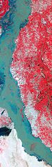
English: In this false-colour image, vegetation is red, and bare ground and settled areas vary in colour from gray to beige. Water ranges in colour from navy blue to teal. The greenish hue of the Indus River likely results from the flooded river’s heavy sediment load. Patches of red in the river hint at the scale of flooding; these areas are farmland submerged by the swollen Indus.
A network of canals connects the Indus to the nearby lake, which also appears flooded. Manchhar Lake (also spelled Manchar Lake) is Pakistan’s largest natural freshwater lake. Located immediately west of the city of Sehwan in the southern Pakistan province of Sindh, Manchhar Lake receives not only rainwater from a vast catchment area in western Sindh, but also fresh river water through the canals. Drainage water also feeds into Manchhar Lake through the Main Nara Valley Drain (not shown), which connects Manchhar to Hamal, another lake to the north. |
| تاریخ | |
| ماخذ | NASA Earth Observatory |
| مصنف | Jesse Allen and Robert Simmon |
Image captured by the Advanced Spaceborne Thermal Emission and Reflection Radiometer (ASTER) on NASA’s Terra satellite. Data provided courtesy of the NASA/GSFC/METI/ERSDAC/JAROS, and U.S./Japan ASTER Science Team.
اجازہ کاری
| This file is in the public domain in the United States because it was solely created by NASA. NASA copyright policy states that "NASA material is not protected by copyright unless noted". (See Template:PD-USGov, NASA copyright policy page or JPL Image Use Policy.) | ||
 |
Warnings:
|
| Annotations | This image is annotated: View the annotations at Commons |
فائل کا تاریخچہ
کسی خاص وقت یا تاریخ میں یہ فائل کیسی نظر آتی تھی، اسے دیکھنے کے لیے اس وقت/تاریخ پر کلک کریں۔
| تاریخ/وقت | تھمب نیل | ابعاد | صارف | تبصرہ | |
|---|---|---|---|---|---|
| رائج الوقت | 09:55، 10 ستمبر 2010ء | 2,407 × 7,592 (3.23 MB) | Originalwana | {{Information |Description={{en|1=In this false-colour image, vegetation is red, and bare ground and settled areas vary in colour from gray to beige. Water ranges in colour from navy blue to teal. The greenish hue of the Indus River li |
روابط
درج ذیل صفحہ اس فائل کو استعمال کر رہا ہے:
فائل کا عالمی استعمال
مندرجہ ذیل ویکیوں میں یہ فائل زیر استعمال ہے: