فائل:Italy 1494 AD.png

اس نمائش کا حجم: 419 × 600 پکسلز۔ دیگر تصمیمات: 168 × 240 پکسلز | 335 × 480 پکسلز | 536 × 768 پکسلز | 1,261 × 1,805 پکسلز۔
اصل فائل (1,261 × 1,805 پکسل، فائل کا حجم: 144 کلوبائٹ، MIME قسم: image/png)


|
File:Italy 1494 AD-it.svg is a vector version of this file. It should be used in place of this PNG file when not inferior.
File:Italy 1494 AD.png → File:Italy 1494 AD-it.svg
For more information, see Help:SVG. |
 |
خلاصہ
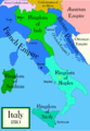
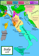
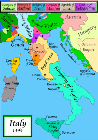
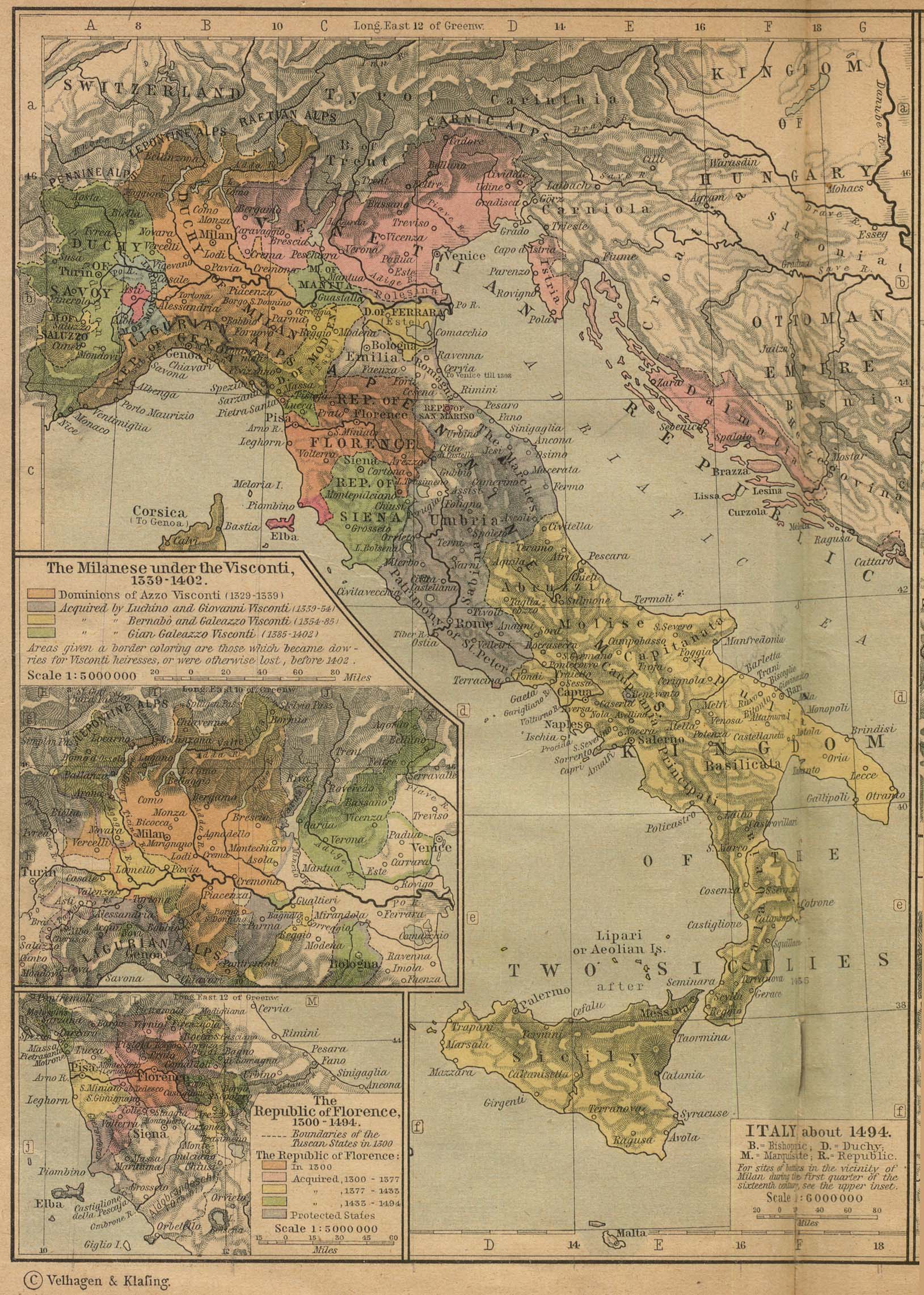
Political map of Italy in early 1494, before the invasion of Italy by Charles VIII of France, created by MapMaster.
Part of a series of maps on the history of Italy:
-
 1000 AD
 -
 1084 AD
 -
 1796 AD
 -
 1810 AD


Versions
[]
PNG:
-
 عربی
عربی -
 انگریزی
 -
 یونانی


SVG:
-
 فرانسیسی
 -
 اطالوی
 -
 ہنگیرین


References
- Bjorklund, Oddvar; Holmboe, Haakon; Rohr, Anders (1970) Historical Atlas of the World, Barnes & Noble, NY, SBN: 389-00253-4.
- Matthew, Donald, (1983), Atlas of Medieval Europe, Checkmark Books, New York.
- Online maps, including this 1882 map from Shepherd (the University of Texas)
- this one from A B Longman, textbook publisher.
اجازہ کاری
میں اس کام کا کاپی رائٹ ہولڈر ہوں اور اسے مندرجہ ذیل اجازت ناموں کے تحت شائع کیا ہے:

|
آپ کو آزاد سافٹ ویئر فاؤنڈیشن کی جانب سے شائع کردہ جی این یو آزاد مسوداتی اجازت نامہ کی شرائط استعمال کے تحت اس دستاویز کو نقل، تقسیم اور/ یا ترمیم کرنے کی اجازت دی جاتی ہے۔ اس اجازت نامہ کی ایک نقل 'جی این یو آزاد مسوداتی اجازت نامہ کے عنوان سے میسر ہے۔ |
| اس ملف کا لائسنس Creative Commons Attribution-Share Alike 3.0 Unported کے تحط ہے۔ | ||
| ||
| This licensing tag was added to this file as part of the GFDL licensing update. |
آپ حسب منشا اجازت نامہ منتخب کر سکتے ہیں۔
derivative works
Derivative works of this file: Italy 1494 AD-ar.png
فائل کا تاریخچہ
کسی خاص وقت یا تاریخ میں یہ فائل کیسی نظر آتی تھی، اسے دیکھنے کے لیے اس وقت/تاریخ پر کلک کریں۔
| تاریخ/وقت | تھمب نیل | ابعاد | صارف | تبصرہ | |
|---|---|---|---|---|---|
| رائج الوقت | 01:15، 21 اپریل 2009ء | | 1,261 × 1,805 (144 کلوبائٹ) | Capmo | palette reduction to 256 colours |
| 22:04، 14 اپریل 2007ء |  | 1,261 × 1,805 (539 کلوبائٹ) | MapMaster | Minor modifications | |
| 16:07، 27 فروری 2007ء |  | 1,167 × 1,642 (471 کلوبائٹ) | MapMaster | Modification suggested by User:Paolo da Reggio | |
| 23:52، 8 جنوری 2007ء |  | 1,135 × 1,625 (472 کلوبائٹ) | MapMaster | Political map of Italy in early 1494, before the invasion of Italy by Charles VIII of France, created by MapMaster. |
روابط
درج ذیل صفحہ اس فائل کو استعمال کر رہا ہے:
فائل کا عالمی استعمال
مندرجہ ذیل ویکیوں میں یہ فائل زیر استعمال ہے:
- af.wikipedia.org پر استعمال
- azb.wikipedia.org پر استعمال
- az.wikipedia.org پر استعمال
- bg.wikipedia.org پر استعمال
- br.wikipedia.org پر استعمال
- bxr.wikipedia.org پر استعمال
- ca.wikipedia.org پر استعمال
- cs.wikipedia.org پر استعمال
- de.wikipedia.org پر استعمال
- el.wikipedia.org پر استعمال
- en.wikipedia.org پر استعمال
- Pope Alexander VI
- Renaissance
- Italian Wars
- Gonzalo Fernández de Córdoba
- Duke of Ferrara and of Modena
- Italian War of 1494–1495
- List of rulers of Montferrat
- User:MapMaster
- Military history of Italy
- User:Juanpdp/Italy
- User:Bolonium/Renaissance
- Marquisate of Incisa
- Timeline of Niccolò Machiavelli
- Italic League
- eo.wikipedia.org پر استعمال
- es.wikipedia.org پر استعمال
- et.wikipedia.org پر استعمال
- fa.wikipedia.org پر استعمال
اس فائل کا مزید عالمی استعمال دیکھیے۔