فائل:Kingdom of France 1000.svg

اس SVG فائل کی PNG نمائش کا حجم: 485 × 340 پکسلز دیگر تصمیمات: 320 × 224 پکسلز | 640 × 449 پکسلز | 1,024 × 718 پکسلز | 1,280 × 897 پکسلز | 2,560 × 1,795 پکسلز۔
اصل فائل (ایس وی جی فائل، ابعاد 485 × 340 پکسل، فائل کا حجم: 1.22 MB)
خلاصہ
This W3C-unspecified vector image was created with Inkscape .


.svg)
.svg)
.svg)
.svg)
.svg)


.svg)
.svg)
.svg)


.png)
.png)


.svg)


.svg)

.svg)


.svg)
.svg)
.svg)
.svg)


.svg)
.png)


.svg)


.svg)
.svg)


.svg)


.svg)


.svg)
.svg)
.svg)
.svg)
.svg)
.svg)
.svg)
.svg)
_cropped.svg)
.svg)
.svg)
.svg)
.svg)
.svg)
.svg)
.svg)
.svg)
.svg)
.svg)
.svg)
.svg)
.svg)
.svg)
.svg)
.svg)
.svg)
.svg)
.svg)
.svg)
.svg)
.svg)
.svg)
.svg)
.svg)
.svg)
.svg)
.svg)
.svg)
.svg)
.svg)
.svg)
.svg)
.svg)
.svg)
.svg)
.svg)
.svg)
.svg)
.svg)
.svg)
.svg)
.svg)
.svg)
.svg)
اجازہ کاری
This file is licensed under the Creative Commons Attribution-Share Alike 4.0 International license.
- آپ آزاد ہیں:
- شیئر کرنے – کام کو نقل، تقسیم یا منتقل کرنے کے لیے
- ریمکس کے لیے – کام منبطق کرنے کے لیے
- مندرجہ ذیل شرائط کے تحت:
- انتساب – آپ کو اس کام کا انتساب مصنف یا اجازت دہندہ کے بتائے گئے طریقہ کے مطابق دینا ہوگا (تاہم یہ انتساب اس طرح نہیں ہونا چاہیے کہ اسے دیکھ کر ایسا محسوس ہو کہ اصل مصنف یا اجازت دہندہ آپ کے یا آپ کے ذریعہ اس کام کے استعمال کرنے کے حامی ہیں)۔
- یکساں شراکت – اگر آپ اس کام میں کوئی تبدیلی یا ترمیم کرتے ہیں یا اس کام پر مبنی کچھ نیا بناتے ہیں تو اسے بھی آپ اسی یا اس جیسے کسی اجازت نامے کے تحت شائع کر سکتے ہیں۔
فائل کا تاریخچہ
کسی خاص وقت یا تاریخ میں یہ فائل کیسی نظر آتی تھی، اسے دیکھنے کے لیے اس وقت/تاریخ پر کلک کریں۔
| تاریخ/وقت | تھمب نیل | ابعاد | صارف | تبصرہ | |
|---|---|---|---|---|---|
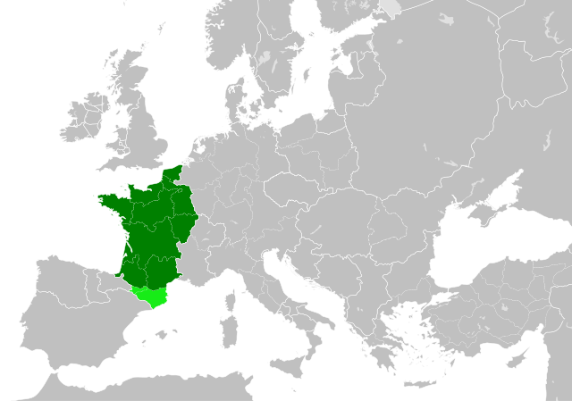
| رائج الوقت | 22:55، 19 جولائی 2023ء | | 485 × 340 (1.22 MB) | Wario2 | The counties of Barcelona and Aragon were autonomous (de facto independent) and not an integral part of the realm) |
| 16:22، 23 مئی 2016ء |  | 485 × 340 (1.25 MB) | Alphathon | Corrected Flanders and incorporated some islands into their respective counties/duchies | |
| 14:41، 23 مئی 2016ء |  | 485 × 340 (1.25 MB) | Alphathon | Corrected status of Bohemia | |
| 18:13، 22 مئی 2016ء |  | 485 × 340 (1.23 MB) | Alphathon | Split Capua from Benevento and removed both from HRE, along with Spoleto | |
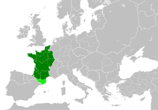
| 16:46، 22 مئی 2016ء |  | 485 × 340 (1.24 MB) | Alphathon | == {{int:filedesc}} == {{Inkscape}} {{Information |Description={{en|A map of the en:Kingdom of France within Europe circa 1000 CE. The main subdivisions of the Byzantine Empire, Holy Roman Empire, Burgundy, France and Poland are also shown.}} |So... |
روابط
درج ذیل صفحہ اس فائل کو استعمال کر رہا ہے:
فائل کا عالمی استعمال
مندرجہ ذیل ویکیوں میں یہ فائل زیر استعمال ہے:
- arz.wikipedia.org پر استعمال
- cs.wikipedia.org پر استعمال
- da.wikipedia.org پر استعمال
- en.wikipedia.org پر استعمال
- es.wikipedia.org پر استعمال
- fa.wikipedia.org پر استعمال
- he.wikipedia.org پر استعمال
- it.wikipedia.org پر استعمال
- ko.wikipedia.org پر استعمال
- mn.wikipedia.org پر استعمال
- nrm.wikipedia.org پر استعمال
- simple.wikipedia.org پر استعمال
- sl.wikipedia.org پر استعمال
- th.wikipedia.org پر استعمال
- tr.wikipedia.org پر استعمال
- uk.wikipedia.org پر استعمال
- vi.wikipedia.org پر استعمال
- www.wikidata.org پر استعمال
- zh.wikipedia.org پر استعمال
.svg)