فائل:Locatie Floreszee.PNG
اس سے زیادہ ریزولیوشن دستیاب نہیں۔
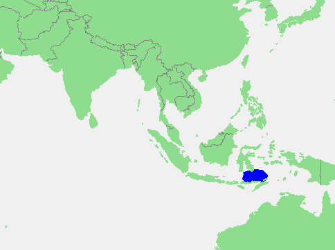
Locatie_Floreszee.PNG (484 × 362 پکسل، فائل کا حجم: 12 کلوبائٹ، MIME قسم: image/png)
| تفصیل | Flores Sea | ||||
| ماخذ | own work based on PD map | ||||
| مصنف | edited by M.Minderhoud | ||||
| اجازت (فائل کا دوبارہ استعمال) |
|
فائل کا تاریخچہ
کسی خاص وقت یا تاریخ میں یہ فائل کیسی نظر آتی تھی، اسے دیکھنے کے لیے اس وقت/تاریخ پر کلک کریں۔
| تاریخ/وقت | تھمب نیل | ابعاد | صارف | تبصرہ | |
|---|---|---|---|---|---|
| رائج الوقت | 12:37، 17 ستمبر 2006ء | | 484 × 362 (12 کلوبائٹ) | Michiel1972 | {{Information |Description= Flores Sea |Source= own work based on PD map |Date= |Author= edited by M.Minderhoud |Permission= {{PD-Demis}} |other_versions= }} category:Locator maps of seas |
روابط
درج ذیل صفحہ اس فائل کو استعمال کر رہا ہے:
فائل کا عالمی استعمال
مندرجہ ذیل ویکیوں میں یہ فائل زیر استعمال ہے:
- af.wikipedia.org پر استعمال
- an.wikipedia.org پر استعمال
- ar.wikipedia.org پر استعمال
- avk.wikipedia.org پر استعمال
- az.wikipedia.org پر استعمال
- ban.wikipedia.org پر استعمال
- ba.wikipedia.org پر استعمال
- be-tarask.wikipedia.org پر استعمال
- br.wikipedia.org پر استعمال
- bs.wikipedia.org پر استعمال
- ca.wikipedia.org پر استعمال
- cs.wikipedia.org پر استعمال
- cv.wikipedia.org پر استعمال
- da.wikipedia.org پر استعمال
- de.wikipedia.org پر استعمال
- el.wikipedia.org پر استعمال
- en.wikipedia.org پر استعمال
- eo.wikipedia.org پر استعمال
- es.wikipedia.org پر استعمال
- fa.wikipedia.org پر استعمال
- fi.wikipedia.org پر استعمال
- frr.wikipedia.org پر استعمال
- fr.wikipedia.org پر استعمال
- fy.wikipedia.org پر استعمال
- gl.wikipedia.org پر استعمال
- id.wikipedia.org پر استعمال
- ilo.wikipedia.org پر استعمال
- is.wikipedia.org پر استعمال
- it.wikipedia.org پر استعمال
- ja.wikipedia.org پر استعمال
- jv.wikipedia.org پر استعمال
- ka.wikipedia.org پر استعمال
- kk.wikipedia.org پر استعمال
- ko.wikipedia.org پر استعمال
- la.wikipedia.org پر استعمال
- lt.wikipedia.org پر استعمال
- mhr.wikipedia.org پر استعمال
- mk.wikipedia.org پر استعمال
- ml.wikipedia.org پر استعمال
- ms.wikipedia.org پر استعمال
- nl.wikipedia.org پر استعمال
- nn.wikipedia.org پر استعمال
- no.wikipedia.org پر استعمال
اس فائل کا مزید عالمی استعمال دیکھیے۔