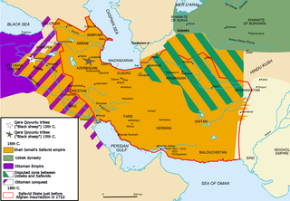
فائل:Map Safavid persia.png

اس نمائش کا حجم: 800 × 555 پکسلز۔ دیگر تصمیمات: 320 × 222 پکسلز | 640 × 444 پکسلز | 1,033 × 717 پکسلز۔
اصل فائل (1,033 × 717 پکسل، فائل کا حجم: 290 کلوبائٹ، MIME قسم: image/png)

|
This historical map image could be re-created using vector graphics as an SVG file. This has several advantages; see Commons:Media for cleanup for more information. If an SVG form of this image is available, please upload it and afterwards replace this template with
{{vector version available|new image name}}.
It is recommended to name the SVG file “Map Safavid persia.svg”—then the template Vector version available (or Vva) does not need the new image name parameter. |
|
میں اس تخلیقی کام کے حقوق کا مالک ہوں اور اسے مندرجہ ذیل اجازت نامے کے تحت شائع کرتا ہوں: This file is licensed under the Creative Commons Attribution-Share Alike 2.5 Generic, 2.0 Generic and 1.0 Generic license.
|
|
|
|
Note : |

See also french version: Image:Map Safavid Persia-fr.png
فائل کا تاریخچہ
کسی خاص وقت یا تاریخ میں یہ فائل کیسی نظر آتی تھی، اسے دیکھنے کے لیے اس وقت/تاریخ پر کلک کریں۔
| تاریخ/وقت | تھمب نیل | ابعاد | صارف | تبصرہ | |
|---|---|---|---|---|---|
| رائج الوقت | 15:27، 14 جولائی 2011ء | | 1,033 × 717 (290 کلوبائٹ) | Kentronhayastan | prvious edit didn't work.. |
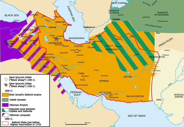
| 15:25، 14 جولائی 2011ء |  | 1,033 × 717 (290 کلوبائٹ) | Kentronhayastan | fixed innacuracy about map: added ARRAN and SHIRVAN, very important regions in the Caucasus. | |
| 21:55، 13 ستمبر 2006ء |  | 1,033 × 717 (318 کلوبائٹ) | Fabienkhan | <div style="height:8px; border:1px solid #8898BF; -moz-border-radius-topleft:8px; -moz-border-radius-topright:8px; background:#C8D8FF; font-size:1px;"> </div> <div style="margin-bottom:1.5em; border:1px solid #8898BF; border-top:0; padding:5px; background |
روابط
درج ذیل 7 صفحات اس فائل کو استعمال کر رہے ہیں:
فائل کا عالمی استعمال
مندرجہ ذیل ویکیوں میں یہ فائل زیر استعمال ہے:
- af.wikipedia.org پر استعمال
- ar.wikipedia.org پر استعمال
- arz.wikipedia.org پر استعمال
- azb.wikipedia.org پر استعمال
- az.wikipedia.org پر استعمال
- bg.wikipedia.org پر استعمال
- bs.wikipedia.org پر استعمال
- ca.wikipedia.org پر استعمال
- cs.wikipedia.org پر استعمال
- de.wikipedia.org پر استعمال
- de.wikibooks.org پر استعمال
- de.wikiversity.org پر استعمال
- el.wikipedia.org پر استعمال
- en.wikipedia.org پر استعمال
- Ismail I
- Russo-Persian Wars
- History of Azerbaijan
- Portal:Azerbaijan
- Iraq
- Ottoman–Safavid relations
- Talk:Afghanistan/Archive 2
- Armenia
- Ottoman–Safavid War (1623–1639)
- Safavid Iran
- Talk:Babur/Archive 3
- Khalifeh Soltan
- User:GerardM/Battles including the Ottoman Empire
- User:Falcaorib
- Talk:Azerbaijan/Archive 8
- Talk:Armenia/Archive 9
- User:Wijbrand/sandbox
- eo.wikipedia.org پر استعمال
- es.wikipedia.org پر استعمال
- fa.wikipedia.org پر استعمال
- fr.wikipedia.org پر استعمال
اس فائل کا مزید عالمی استعمال دیکھیے۔