فائل:Map of Oudomxai Province, Laos.jpg

اصل فائل (1,195 × 931 پکسل، فائل کا حجم: 724 کلوبائٹ، MIME قسم: image/jpeg)
خلاصہ
| تفصیل |
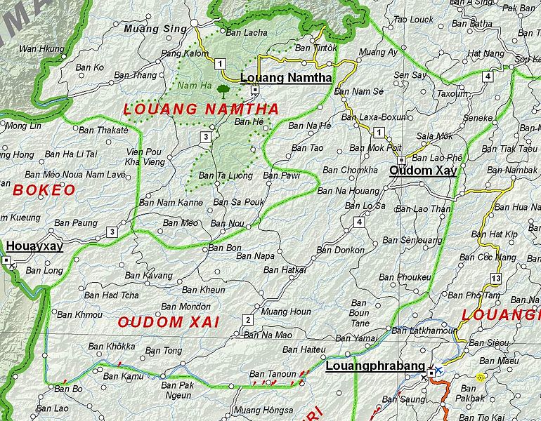
English: Map of Oudomxai Province, Laos. |
| تاریخ | |
| ماخذ | Based on File:UNOSAT Laos Base Map.jpg |
| مصنف | UNOSAT, United Nations, modified by Dr. Blofeld |
| اجازت (فائل کا دوبارہ استعمال) |
The original file is marked with the UN symbol which means that it is a public domain resource. |
اجازہ کاری
| This image is a map derived from a United Nations map.
Unless stated otherwise, UN maps are to be considered in the public domain. This applies worldwide. UN maps are, in principle, open source material and you can use them in your work or for making your own map. UN requests however that you delete the UN name, logo and reference number upon any modification to the map. Content of your map will be your responsibility. You can state in your publication, if you wish, something like: based on UN map … (map name, map number, revision number and date). See: Geospatial Information Section. And: Geospatial, location data for a better world. |
 |
فائل کا تاریخچہ
کسی خاص وقت یا تاریخ میں یہ فائل کیسی نظر آتی تھی، اسے دیکھنے کے لیے اس وقت/تاریخ پر کلک کریں۔
| تاریخ/وقت | تھمب نیل | ابعاد | صارف | تبصرہ | |
|---|---|---|---|---|---|
| رائج الوقت | 21:02، 6 دسمبر 2012ء | | 1,195 × 931 (724 کلوبائٹ) | Blofeld Dr. | {{Information |Description ={{en|1=d}} |Source =d |Author =d |Date =d |Permission = |other_versions = }} d |
روابط
درج ذیل صفحہ اس فائل کو استعمال کر رہا ہے:
فائل کا عالمی استعمال
مندرجہ ذیل ویکیوں میں یہ فائل زیر استعمال ہے:
- az.wikipedia.org پر استعمال
- de.wikipedia.org پر استعمال
- en.wikipedia.org پر استعمال
- fa.wikipedia.org پر استعمال
- fr.wikipedia.org پر استعمال
- hr.wikipedia.org پر استعمال
- id.wikipedia.org پر استعمال
- ru.wikipedia.org پر استعمال
- th.wikipedia.org پر استعمال
- vi.wikipedia.org پر استعمال