فائل:Map of states showing population density in 2013.svg

اس SVG فائل کی PNG نمائش کا حجم: 800 × 495 پکسلز دیگر تصمیمات: 320 × 198 پکسلز | 640 × 396 پکسلز | 1,024 × 633 پکسلز | 1,280 × 791 پکسلز | 2,560 × 1,583 پکسلز | 959 × 593 پکسلز۔
اصل فائل (ایس وی جی فائل، ابعاد 959 × 593 پکسل، فائل کا حجم: 50 کلوبائٹ)
خلاصہ
| تفصیل |
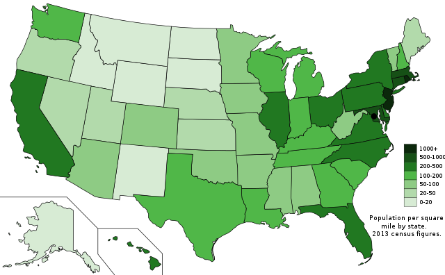
English: The US states with population density shown by people per square mile from the 2013 census, based on data from USCB. |
| تاریخ | |
| ماخذ | ذاتی کام; Map is based on here. |
| مصنف | Ali Zifan |
اجازہ کاری
میں اس تخلیقی کام کے حقوق کا مالک ہوں اور اسے مندرجہ ذیل اجازت نامے کے تحت شائع کرتا ہوں:
| This file is made available under the Creative Commons CC0 1.0 Universal Public Domain Dedication. | |
| The person who associated a work with this deed has dedicated the work to the public domain by waiving all of their rights to the work worldwide under copyright law, including all related and neighboring rights, to the extent allowed by law. You can copy, modify, distribute and perform the work, even for commercial purposes, all without asking permission.
|
فائل کا تاریخچہ
کسی خاص وقت یا تاریخ میں یہ فائل کیسی نظر آتی تھی، اسے دیکھنے کے لیے اس وقت/تاریخ پر کلک کریں۔
| تاریخ/وقت | تھمب نیل | ابعاد | صارف | تبصرہ | |
|---|---|---|---|---|---|
| رائج الوقت | 21:21، 27 نومبر 2014ء | | 959 × 593 (50 کلوبائٹ) | Oganesson007 | عوض کردن جای توضیحات |
| 18:14، 27 نومبر 2014ء |  | 959 × 593 (50 کلوبائٹ) | Oganesson007 | User created page with UploadWizard |
روابط
درج ذیل صفحہ اس فائل کو استعمال کر رہا ہے:
فائل کا عالمی استعمال
مندرجہ ذیل ویکیوں میں یہ فائل زیر استعمال ہے:
- bg.wikipedia.org پر استعمال
- cs.wikipedia.org پر استعمال
- el.wikipedia.org پر استعمال
- en.wikipedia.org پر استعمال
- es.wikipedia.org پر استعمال
- fa.wikipedia.org پر استعمال
- ga.wikipedia.org پر استعمال
- gl.wikipedia.org پر استعمال
- hu.wikipedia.org پر استعمال
- ilo.wikipedia.org پر استعمال
- it.wikipedia.org پر استعمال
- jv.wikipedia.org پر استعمال
- pt.wikipedia.org پر استعمال
- ro.wikipedia.org پر استعمال
- sk.wikipedia.org پر استعمال
- sv.wikipedia.org پر استعمال
- tr.wikipedia.org پر استعمال
- uk.wikipedia.org پر استعمال
- vi.wikipedia.org پر استعمال