فائل:Mapadefosas-mjusticia-es.jpg

اس نمائش کا حجم: 628 × 600 پکسلز۔ دیگر تصمیمات: 251 × 240 پکسلز | 503 × 480 پکسلز | 838 × 800 پکسلز۔
اصل فائل (838 × 800 پکسل، فائل کا حجم: 193 کلوبائٹ، MIME قسم: image/jpeg)
خلاصہ
| تفصیل |
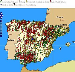
Español: Mapa de fosas de la Guerra Civil Española. Localización geográfica de las fosas o lugares de enterramiento en el territorio español de las que se dispone información, representadas con símbolos de diferentes colores según la actuación realizada sobre cada una de ellas. Verde: Fosa aún no intervenida. Blanco: Fosa aún no encontrada. Amarillo: Transferida al valle de los caídos. Rojo: parcial o totalmente exhumada.
http://mapadefosas.mjusticia.es/exovi_externo/CargarMapaFosas.htm
English: Spanish Civil War graves. Geographic location of the graves or burial places in Spanish territory on which information is available, represented with different coloured symbols based on the level of research performed. Green: No Interventions Undertaken White: Missing grave. Yellow: Transferred to the Valle de los Caídos. Red: Fully or Partially Exhumed. Blue star: Valle de los Caídos. |
| تاریخ | |
| ماخذ | Ministerio de Justicia de España, http://mapadefosas.mjusticia.es/ |
| مصنف | Ministerio de Justicia de España |
| اجازت (فائل کا دوبارہ استعمال) |
trabajo publico gubernamental, publicado en web del ministerio. Envío por mail mensaje de licencia |
| Camera location | | View this and other nearby images on: OpenStreetMap |
|---|
اجازہ کاری
This file is licensed under the Creative Commons Attribution 3.0 Unported license.
- آپ آزاد ہیں:
- شیئر کرنے – کام کو نقل، تقسیم یا منتقل کرنے کے لیے
- ریمکس کے لیے – کام منبطق کرنے کے لیے
- مندرجہ ذیل شرائط کے تحت:
- انتساب – آپ کو اس کام کا انتساب مصنف یا اجازت دہندہ کے بتائے گئے طریقہ کے مطابق دینا ہوگا (تاہم یہ انتساب اس طرح نہیں ہونا چاہیے کہ اسے دیکھ کر ایسا محسوس ہو کہ اصل مصنف یا اجازت دہندہ آپ کے یا آپ کے ذریعہ اس کام کے استعمال کرنے کے حامی ہیں)۔

|
This image has been assessed under the valued image criteria and is considered the most valued image on Commons within the scope: Spanish Civil War casualties. You can see its nomination here. |
فائل کا تاریخچہ
کسی خاص وقت یا تاریخ میں یہ فائل کیسی نظر آتی تھی، اسے دیکھنے کے لیے اس وقت/تاریخ پر کلک کریں۔
| تاریخ/وقت | تھمب نیل | ابعاد | صارف | تبصرہ | |
|---|---|---|---|---|---|
| رائج الوقت | 10:08، 4 مارچ 2013ء | | 838 × 800 (193 کلوبائٹ) | Gaianauta | corrected previous larger scale in E-W direction |
| 16:11، 13 جولائی 2011ء |  | 961 × 800 (225 کلوبائٹ) | Gaianauta | {{Information |Description ={{es|1=Mapa de fosas de la Guerra Civil Espàñola. Localización geográfica de las fosas o lugares de enterramiento en el territorio español de las que se dispone información, representadas con símbolos de diferentes co |
روابط
درج ذیل صفحہ اس فائل کو استعمال کر رہا ہے:
فائل کا عالمی استعمال
مندرجہ ذیل ویکیوں میں یہ فائل زیر استعمال ہے:
- ar.wikipedia.org پر استعمال
- ast.wikipedia.org پر استعمال
- bn.wikipedia.org پر استعمال
- ca.wikipedia.org پر استعمال
- en.wikipedia.org پر استعمال
- es.wikipedia.org پر استعمال
- gl.wikipedia.org پر استعمال
- pl.wikipedia.org پر استعمال