فائل:Martian north polar cap.jpg

اس نمائش کا حجم: 622 × 600 پکسلز۔ دیگر تصمیمات: 249 × 240 پکسلز | 498 × 480 پکسلز | 797 × 768 پکسلز | 1,062 × 1,024 پکسلز | 1,368 × 1,319 پکسلز۔
اصل فائل (1,368 × 1,319 پکسل، فائل کا حجم: 1 MB، MIME قسم: image/jpeg)
خلاصہ
| تفصیل |
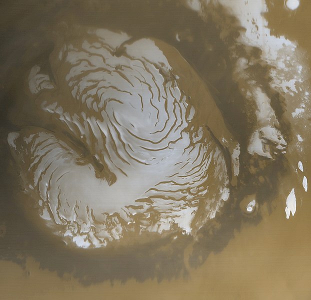
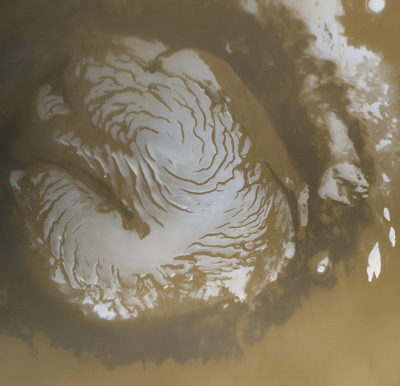
English: The Mars Global Surveyor (MGS) Mars Orbiter Camera (MOC) acquired this image of the Martian north polar cap in early northern summer. The picture was acquired on March 13, 1999, near the start of the Mapping Phase of the MGS mission. The light-toned surfaces are residual water ice that remains through the summer season. The nearly circular band of dark material surrounding the cap consists mainly of sand dunes formed and shaped by wind. The north polar cap is roughly 1100 kilometers (680 miles) across.
Ελληνικά: Ο Βόρειος Πόλος του πλανήτη Άρη, φωτογραφημένος από τη διαστημοσυσκευή Mars Global Surveyor το 1999. Όταν λήφθηκε η φωτογραφία στο βόρειο ημισφαίριο του πλανήτη ήταν καλοκαίρι, και έτσι ο πάγος που παρατηρείται είναι πάγος νερού, που βρίσκεται κάτω από ένα στρώμα πάγου διοξείδιου του άνθρακα, που το καλοκαίρι εξατμίζεται. Η σκοτεινή περιοχή γύρω από τον πάγο είναι μια "θάλασσα" από άμμο που περιβάλλει τον Βόρειο Πόλο.
|
|||||
| تاریخ | The picture was acquired on March 13, 1999 | |||||
| ماخذ | ||||||
| مصنف | NASA/JPL/Malin Space Science Systems | |||||
| اجازت (فائل کا دوبارہ استعمال) |
|

This image or video was catalogued by Jet Propulsion Laboratory of the United States National Aeronautics and Space Administration (NASA) under Photo ID: PIA02800. This tag does not indicate the copyright status of the attached work. A normal copyright tag is still required. See Commons:Licensing. Other languages:
|
فائل کا تاریخچہ
کسی خاص وقت یا تاریخ میں یہ فائل کیسی نظر آتی تھی، اسے دیکھنے کے لیے اس وقت/تاریخ پر کلک کریں۔
| تاریخ/وقت | تھمب نیل | ابعاد | صارف | تبصرہ | |
|---|---|---|---|---|---|
| رائج الوقت | 13:30، 18 ستمبر 2011ء | | 1,368 × 1,319 (1 MB) | Badseed | uploading full resolution |
| 21:53، 3 اگست 2008ء |  | 419 × 404 (134 کلوبائٹ) | BatteryIncluded | {{Information |Description=The Mars Global Surveyor (MGS) Mars Orbiter Camera (MOC) acquired this image of the Martian north polar cap in early northern summer of. The picture was acquired on March 13, 1999, near the start of the Mapping Phase of the MGS |
روابط
درج ذیل صفحہ اس فائل کو استعمال کر رہا ہے:
فائل کا عالمی استعمال
مندرجہ ذیل ویکیوں میں یہ فائل زیر استعمال ہے:
- ar.wikipedia.org پر استعمال
- az.wikipedia.org پر استعمال
- be.wikipedia.org پر استعمال
- ca.wikipedia.org پر استعمال
- de.wikipedia.org پر استعمال
- el.wikipedia.org پر استعمال
- en.wikipedia.org پر استعمال
- en.wikibooks.org پر استعمال
- en.wikiversity.org پر استعمال
- es.wikipedia.org پر استعمال
- eu.wikipedia.org پر استعمال
- fa.wikipedia.org پر استعمال
- fr.wikipedia.org پر استعمال
- he.wikipedia.org پر استعمال
- hi.wikipedia.org پر استعمال
- hr.wikipedia.org پر استعمال
- hy.wikipedia.org پر استعمال
- id.wikipedia.org پر استعمال
- incubator.wikimedia.org پر استعمال
- ja.wikipedia.org پر استعمال
- kv.wikipedia.org پر استعمال
- lb.wikipedia.org پر استعمال
- mnw.wikipedia.org پر استعمال
- pnb.wikipedia.org پر استعمال
- pt.wikipedia.org پر استعمال
- pt.wikibooks.org پر استعمال
- ru.wikipedia.org پر استعمال
- sc.wikipedia.org پر استعمال
اس فائل کا مزید عالمی استعمال دیکھیے۔