فائل:Mazama bathymetry survey map.jpg
اس سے زیادہ ریزولیوشن دستیاب نہیں۔
Mazama_bathymetry_survey_map.jpg (600 × 345 پکسل، فائل کا حجم: 61 کلوبائٹ، MIME قسم: image/jpeg)
| تفصیل |
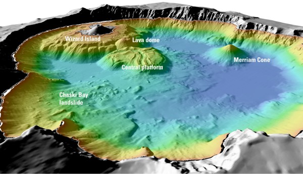
English: "Details of features beneath the surface of Crater Lake constructed using data from the 2000 bathymetry survey. Colors range from orange to blue with increasing water depth." |
| ماخذ | "Mount Mazama and Crater Lake: Growth and Destruction of a Cascade Volcano" |
| مصنف | U.S. Geological Survey |
اجازہ کاری
This image is in the public domain in the United States because it only contains materials that originally came from the United States Geological Survey, an agency of the United States Department of the Interior. For more information, see the official USGS copyright policy.
|
اولین اپلوڈ کا نوشتہ
فائل کی تفصیلات کا اصل صفحہ یہاں تھا۔ درج ذیل تمام صارفین en.wikipedia کے ہیں۔
- 2004-05-18 06:41 Mav 600×345× (62232 bytes) [[USGS]] image from [http://geopubs.wr.usgs.gov/fact-sheet/fs092-02/] <br><br>{{msg:PD}}
فائل کا تاریخچہ
کسی خاص وقت یا تاریخ میں یہ فائل کیسی نظر آتی تھی، اسے دیکھنے کے لیے اس وقت/تاریخ پر کلک کریں۔
| تاریخ/وقت | تھمب نیل | ابعاد | صارف | تبصرہ | |
|---|---|---|---|---|---|
| رائج الوقت | 06:26، 13 جولائی 2009ء | | 600 × 345 (61 کلوبائٹ) | ZabMilenko | {{Information |Description={{en|en:USGS image from [http://geopubs.wr.usgs.gov/fact-sheet/fs092-02/] en:Category:Images of Oregon}} |Source=Transferred from [http://en.wikipedia.org en.wikipedia]; transferred to Commons by [[User:ZabMilenko |
روابط
درج ذیل صفحہ اس فائل کو استعمال کر رہا ہے:
فائل کا عالمی استعمال
مندرجہ ذیل ویکیوں میں یہ فائل زیر استعمال ہے:
- bh.wikipedia.org پر استعمال
- el.wikipedia.org پر استعمال
- en.wikipedia.org پر استعمال
- eo.wikipedia.org پر استعمال
- es.wikipedia.org پر استعمال
- fa.wikipedia.org پر استعمال
- it.wikipedia.org پر استعمال
- ja.wikipedia.org پر استعمال
- lv.wikipedia.org پر استعمال
- ms.wikipedia.org پر استعمال
- simple.wikipedia.org پر استعمال
- sl.wikipedia.org پر استعمال
- vi.wikipedia.org پر استعمال
- www.wikidata.org پر استعمال
- zh.wikipedia.org پر استعمال