فائل:Munnar Top station.jpg

اس نمائش کا حجم: 800 × 494 پکسلز۔ دیگر تصمیمات: 320 × 197 پکسلز | 640 × 395 پکسلز | 1,024 × 632 پکسلز | 1,246 × 769 پکسلز۔
اصل فائل (1,246 × 769 پکسل، فائل کا حجم: 905 کلوبائٹ، MIME قسم: image/jpeg)
خلاصہ
| تفصیل |
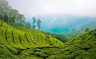
English: Top station, 41 km (1hr) from Munnar is aptly named, as it is home to some of the highest tea plantations in India. It lies on the state border between Kerala and Tamilnadu and commands a panoramic view of rolling green hills. |
||
| تاریخ | |||
| ماخذ | Top Station - Munnar | ||
| مصنف | Bimal K C from Cochin, India | ||
| اجازت (فائل کا دوبارہ استعمال) |
This file is licensed under the Creative Commons Attribution 2.0 Generic license.
|
|
فائل کا تاریخچہ
کسی خاص وقت یا تاریخ میں یہ فائل کیسی نظر آتی تھی، اسے دیکھنے کے لیے اس وقت/تاریخ پر کلک کریں۔
| تاریخ/وقت | تھمب نیل | ابعاد | صارف | تبصرہ | |
|---|---|---|---|---|---|
| رائج الوقت | 13:05، 6 اپریل 2011ء | | 1,246 × 769 (905 کلوبائٹ) | Ras67 | cropped |
| 12:03، 12 اگست 2008ء |  | 1,280 × 803 (952 کلوبائٹ) | Challiyan | {{Information |Description= Top station, 41 km (1hr) from Munnar is aptly named, as it is home to some of the highest tea plantations in India. It lies on the state border between Kerala and Tamilnadu and commands a panoramic view of rolling green hills. |
روابط
درج ذیل صفحہ اس فائل کو استعمال کر رہا ہے:
فائل کا عالمی استعمال
مندرجہ ذیل ویکیوں میں یہ فائل زیر استعمال ہے:
- bo.wikipedia.org پر استعمال
- cs.wikipedia.org پر استعمال
- de.wikipedia.org پر استعمال
- en.wikipedia.org پر استعمال
- en.wikivoyage.org پر استعمال
- es.wikipedia.org پر استعمال
- fr.wikipedia.org پر استعمال
- gu.wikipedia.org پر استعمال
- id.wikipedia.org پر استعمال
- incubator.wikimedia.org پر استعمال
- kn.wikipedia.org پر استعمال
- ml.wikipedia.org پر استعمال
- കേരളം
- മൂന്നാർ
- വിക്കിപീഡിയ:തിരഞ്ഞെടുക്കാവുന്ന ചിത്രങ്ങൾ/നിലവറ 19
- വിക്കിപീഡിയ:തിരഞ്ഞെടുത്ത ചിത്രങ്ങൾ/മേയ് 2016
- വിക്കിപീഡിയ:തിരഞ്ഞെടുത്ത ചിത്രങ്ങൾ/08-05-2016
- വിക്കിപീഡിയ:തിരഞ്ഞെടുത്ത ചിത്രങ്ങൾ/09-05-2016
- വിക്കിപീഡിയ:തിരഞ്ഞെടുത്ത ചിത്രങ്ങൾ/10-05-2016
- വിക്കിപീഡിയ:തിരഞ്ഞെടുത്ത ചിത്രങ്ങൾ/11-05-2016
- വിക്കിപീഡിയ:തിരഞ്ഞെടുത്ത ചിത്രങ്ങൾ/12-05-2016
- വിക്കിപീഡിയ:തിരഞ്ഞെടുത്ത ചിത്രങ്ങൾ/13-05-2016
- വിക്കിപീഡിയ:തിരഞ്ഞെടുത്ത ചിത്രങ്ങൾ/14-05-2016
- nl.wikipedia.org پر استعمال
- no.wiktionary.org پر استعمال
- pl.wikipedia.org پر استعمال
- ru.wikipedia.org پر استعمال
- sa.wikipedia.org پر استعمال
- sv.wikipedia.org پر استعمال
- ta.wikipedia.org پر استعمال
- te.wikipedia.org پر استعمال
- war.wikipedia.org پر استعمال