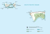
فائل:NPS american-samoa-manua-islands-map.jpg

اس نمائش کا حجم: 800 × 550 پکسلز۔ دیگر تصمیمات: 320 × 220 پکسلز | 640 × 440 پکسلز | 1,024 × 704 پکسلز | 1,280 × 880 پکسلز | 1,493 × 1,027 پکسلز۔
اصل فائل (1,493 × 1,027 پکسل، فائل کا حجم: 106 کلوبائٹ، MIME قسم: image/jpeg)
فائل کا تاریخچہ
کسی خاص وقت یا تاریخ میں یہ فائل کیسی نظر آتی تھی، اسے دیکھنے کے لیے اس وقت/تاریخ پر کلک کریں۔
| تاریخ/وقت | تھمب نیل | ابعاد | صارف | تبصرہ | |
|---|---|---|---|---|---|
| رائج الوقت | 06:33، 12 مئی 2017ء |  | 1,493 × 1,027 (106 کلوبائٹ) | RKBot | =={{int:filedesc}}== {{Information |description= {{en|1=Map of American Samoa lands on Manu’a Islands, including both Ofu and Ta’u.}} |date= 2016-02-22 |source= U.S. National Park Service (http://npmaps.com/wp-content/uploads/american-samoa-manua-i... |
روابط
درج ذیل صفحہ اس فائل کو استعمال کر رہا ہے:
فائل کا عالمی استعمال
مندرجہ ذیل ویکیوں میں یہ فائل زیر استعمال ہے:
- ban.wikipedia.org پر استعمال
- en.wikipedia.org پر استعمال
- fr.wikipedia.org پر استعمال
- uk.wikipedia.org پر استعمال

