فائل:Northern Ghana districts.png
اصل فائل (1,056 × 816 پکسل، فائل کا حجم: 49 کلوبائٹ، MIME قسم: image/png)
خلاصہ
| تفصیل |
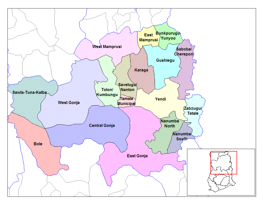
from en:districts of ghana Map of the districts of the Northern region of Ghana. Created by Rarelibra for public domain use. Created using MapInfo Professional v7.5 and various mapping resources.11 I, the creator of this work, hereby release it into the public domain. This applies worldwide. In case this is not legally possible, I grant any entity the right to use this work for any purpose, without any conditions, unless such conditions are required by law. File history |
| تاریخ | 28 جون 2006 (original upload date) |
| ماخذ | No machine-readable source provided. Own work assumed (based on copyright claims). |
| مصنف | No machine-readable author provided. Ahanta assumed (based on copyright claims). |
اجازہ کاری
| میں اس تخلیقی کام کے حقوق کا مالک ہوں اور اسے دائرہ عام میں شائع کرتا ہوں جس کا اطلاق عالمی سطح پر ہوتا ہے۔ بعض ملکوں میں یہ قانونی طور پر شاید ممکن نہ ہو؛ اگر ایسا ہے تو: میں ہر ایک کو کسی بھی مقصد کے لیے بغیر کسی شرط کے اس تصویر کے استعمال کا حق تفویض کرتا/کرتی ہوں، بجز اس صورت کے جس میں کوئی قانونی رکاوٹ موجود ہو۔ |
فائل کا تاریخچہ
کسی خاص وقت یا تاریخ میں یہ فائل کیسی نظر آتی تھی، اسے دیکھنے کے لیے اس وقت/تاریخ پر کلک کریں۔
| تاریخ/وقت | تھمب نیل | ابعاد | صارف | تبصرہ | |
|---|---|---|---|---|---|
| رائج الوقت | 10:53، 28 جون 2006ء | | 1,056 × 816 (49 کلوبائٹ) | Ahanta | from en:districts of ghana Map of the districts of the Northern region of Ghana. Created by Rarelibra for public domain use. Created using MapInfo Professional v7.5 and various mapping resources. I, the creator of this work, hereby release it into the p |
روابط
درج ذیل 2 صفحات اس فائل کو استعمال کر رہے ہیں:
فائل کا عالمی استعمال
مندرجہ ذیل ویکیوں میں یہ فائل زیر استعمال ہے:
- ca.wikipedia.org پر استعمال
- ceb.wikipedia.org پر استعمال
- dag.wikipedia.org پر استعمال
- da.wikipedia.org پر استعمال
- de.wikipedia.org پر استعمال
- en.wikipedia.org پر استعمال
- Tolon-Kumbungu District
- Zabzugu-Tatale District
- User talk:Rarelibra/Maps2
- List of hospitals in Ghana
- List of Ghana Parliament constituencies
- Yendi Municipal District
- User:GerardM/Districts of Ghana
- Bunkpurugu-Yunyoo District
- Saboba-Chereponi District
- Nanumba District
- Gushegu-Karaga District
- Mamprusi District
- West Dagomba District
- East Dagomba District
- es.wikipedia.org پر استعمال
- fa.wikipedia.org پر استعمال
- fr.wikipedia.org پر استعمال
- gpe.wikipedia.org پر استعمال
- ha.wikipedia.org پر استعمال
- ig.wikipedia.org پر استعمال
- it.wikipedia.org پر استعمال
اس فائل کا مزید عالمی استعمال دیکھیے۔