فائل:Northern Mali conflict.svg

اس SVG فائل کی PNG نمائش کا حجم: 629 × 600 پکسلز دیگر تصمیمات: 252 × 240 پکسلز | 503 × 480 پکسلز | 805 × 768 پکسلز | 1,074 × 1,024 پکسلز | 2,148 × 2,048 پکسلز | 1,316 × 1,255 پکسلز۔
اصل فائل (ایس وی جی فائل، ابعاد 1,316 × 1,255 پکسل، فائل کا حجم: 796 کلوبائٹ)
خلاصہ
| تفصیل |
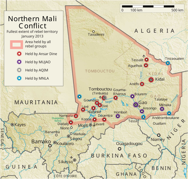
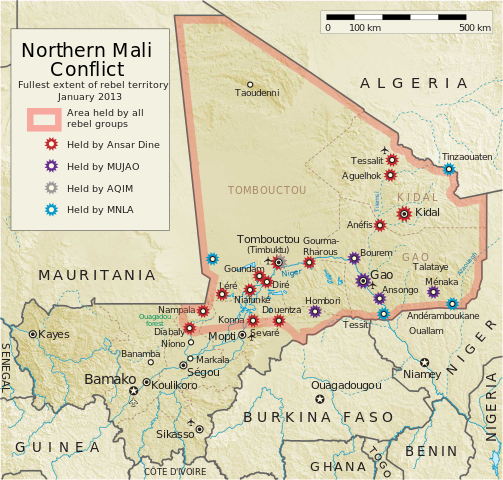
English: Map of the conflict in Northern Mali. (English)
العربية: خريطة الصّراع في شمال مالي. (إنجليزي)
Français : Carte du conflit au nord du Mali. (Anglais)
Latina: Charta rebellionis Tuaregorum in Malia septentrionali. (Anglice)
Українська: Карта конфлікту на півночі Малі. (Англійською) |
| ماخذ |
ذاتی کام This vector image includes elements that have been taken or adapted from this file: This vector image includes elements that have been taken or adapted from this file: |
| مصنف | Orionist |
| دوسرے نسخے | German/Deutsch/Allemand, French/Français, Macedonian/македонски јазик/Macédonien |
| SVG genesis |
Notes
- ↑ US Department of State, "Country Reports on Terrorism 2011", Chapter 2 Country Reports: Africa Overview, 31 July 2012
اجازہ کاری
میں اس تخلیقی کام کے حقوق کا مالک ہوں اور اسے مندرجہ ذیل اجازت نامے کے تحت شائع کرتا ہوں:
اس ملف کا لائسنس Creative Commons Attribution-Share Alike 3.0 Unported کے تحط ہے۔
- آپ آزاد ہیں:
- شیئر کرنے – کام کو نقل، تقسیم یا منتقل کرنے کے لیے
- ریمکس کے لیے – کام منبطق کرنے کے لیے
- مندرجہ ذیل شرائط کے تحت:
- انتساب – آپ کو اس کام کا انتساب مصنف یا اجازت دہندہ کے بتائے گئے طریقہ کے مطابق دینا ہوگا (تاہم یہ انتساب اس طرح نہیں ہونا چاہیے کہ اسے دیکھ کر ایسا محسوس ہو کہ اصل مصنف یا اجازت دہندہ آپ کے یا آپ کے ذریعہ اس کام کے استعمال کرنے کے حامی ہیں)۔
- یکساں شراکت – اگر آپ اس کام میں کوئی تبدیلی یا ترمیم کرتے ہیں یا اس کام پر مبنی کچھ نیا بناتے ہیں تو اسے بھی آپ اسی یا اس جیسے کسی اجازت نامے کے تحت شائع کر سکتے ہیں۔
فائل کا تاریخچہ
کسی خاص وقت یا تاریخ میں یہ فائل کیسی نظر آتی تھی، اسے دیکھنے کے لیے اس وقت/تاریخ پر کلک کریں۔
| تاریخ/وقت | تھمب نیل | ابعاد | صارف | تبصرہ | |
|---|---|---|---|---|---|
| رائج الوقت | 06:59، 8 اپریل 2014ء | | 1,316 × 1,255 (796 کلوبائٹ) | Ansh666 | Reverted to version as of 16:51, 8 March 2013 - restoring the correct version, as the map is supposed to be historical, not current |
| 20:15، 5 دسمبر 2013ء |  | 1,316 × 1,255 (699 کلوبائٹ) | Hanibal911 | more accurately reflects the situation | |
| 16:51، 8 مارچ 2013ء |  | 1,316 × 1,255 (796 کلوبائٹ) | Agricolae | Hombori dot restored | |
| 14:29، 5 مارچ 2013ء |  | 1,316 × 1,255 (794 کلوبائٹ) | TUFKAAP | Since this is an English map, Al-Qaeda in the Islamic Maghreb should be abbreviated as AQIM. | |
| 03:33، 11 فروری 2013ء |  | 1,316 × 1,255 (794 کلوبائٹ) | Agricolae | shift text distorted on upload | |
| 03:27، 11 فروری 2013ء |  | 1,316 × 1,255 (794 کلوبائٹ) | Agricolae | change to show greatest extent - see WP Talk:Northern Mali conflict (2012–present) | |
| 06:36، 8 فروری 2013ء |  | 1,316 × 1,255 (699 کلوبائٹ) | Rama | Aguelhok contested or taken ( http://www.lemonde.fr/afrique/article/2013/02/08/mali-les-forces-francaise-et-tchadiennes-a-aguelhok_1828906_3212.html ) | |
| 10:29، 2 فروری 2013ء |  | 1,316 × 1,255 (698 کلوبائٹ) | U5K0 | Bourem to green as per talk page | |
| 08:41، 30 جنوری 2013ء |  | 1,316 × 1,255 (679 کلوبائٹ) | Orionist | Updated map: Menaka, Anderamboukane, Ansongo, Dire, Kidal and other MNLA positions. Removed rebel area boundaries as the situation has become complicated. | |
| 17:23، 29 جنوری 2013ء |  | 1,316 × 1,255 (894 کلوبائٹ) | Jaybear | Insertion of a map-scale in the upper right corner (added directly before the token "/svg" at end of svg-code); |
روابط
درج ذیل صفحہ اس فائل کو استعمال کر رہا ہے:
فائل کا عالمی استعمال
مندرجہ ذیل ویکیوں میں یہ فائل زیر استعمال ہے:
- af.wikipedia.org پر استعمال
- ar.wikipedia.org پر استعمال
- azb.wikipedia.org پر استعمال
- az.wikipedia.org پر استعمال
- bg.wikipedia.org پر استعمال
- bn.wikipedia.org پر استعمال
- ca.wikipedia.org پر استعمال
- cs.wikipedia.org پر استعمال
- cy.wikipedia.org پر استعمال
- da.wikipedia.org پر استعمال
- de.wikipedia.org پر استعمال
- el.wikipedia.org پر استعمال
- en.wikipedia.org پر استعمال
- Mali
- Portal:Mali
- Insurgency in the Maghreb (2002–present)
- War on terror
- User:Orionist/Gallery
- National Movement for the Liberation of Azawad
- Wikipedia talk:WikiProject Maps/Archive 2012
- Wikipedia:In the news/Candidates/April 2012
- Wikipedia:Graphics Lab/Map workshop/Archive/Apr 2012
- Wikipedia:Wikipedia Signpost/2012-04-30/WikiProject report
- Wikipedia:Wikipedia Signpost/Single/2012-04-30
- Mali War
- Wikipedia:WikiProject Maps/Conventions/Pushpin maps
- Operation Serval
- Chadian intervention in northern Mali
- Islamist insurgency in the Sahel
- User:AlbanianEditor1990/sandbox
- en.wikinews.org پر استعمال
- eo.wikipedia.org پر استعمال
- es.wikipedia.org پر استعمال
- et.wikipedia.org پر استعمال
- eu.wikipedia.org پر استعمال
- fi.wikipedia.org پر استعمال
اس فائل کا مزید عالمی استعمال دیکھیے۔