فائل:Peloponnesos Map.png
اصل فائل (808 × 852 پکسل، فائل کا حجم: 234 کلوبائٹ، MIME قسم: image/png)
| تفصیل |
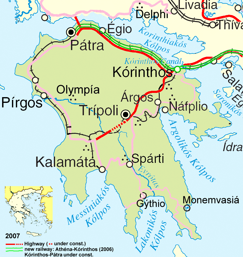
Deutsch: Wichtigste Verkehrsachsen des Peloponnes, Stand 2007.
English: Main traffic lines in the Peloponnese, as of 2007. |
| تاریخ | |
| ماخذ | see author |
| مصنف | ulrichstill |
| دوسرے نسخے | Adapted from http://www.un.org/Depts/Cartographic/map/profile/greece.pdf |
- آپ آزاد ہیں:
- شیئر کرنے – کام کو نقل، تقسیم یا منتقل کرنے کے لیے
- ریمکس کے لیے – کام منبطق کرنے کے لیے
- مندرجہ ذیل شرائط کے تحت:
- انتساب – آپ کو اس کام کا انتساب مصنف یا اجازت دہندہ کے بتائے گئے طریقہ کے مطابق دینا ہوگا (تاہم یہ انتساب اس طرح نہیں ہونا چاہیے کہ اسے دیکھ کر ایسا محسوس ہو کہ اصل مصنف یا اجازت دہندہ آپ کے یا آپ کے ذریعہ اس کام کے استعمال کرنے کے حامی ہیں)۔
- یکساں شراکت – اگر آپ اس کام میں کوئی تبدیلی یا ترمیم کرتے ہیں یا اس کام پر مبنی کچھ نیا بناتے ہیں تو اسے بھی آپ اسی یا اس جیسے کسی اجازت نامے کے تحت شائع کر سکتے ہیں۔

| This image is a map derived from a United Nations map.
Unless stated otherwise, UN maps are to be considered in the public domain. This applies worldwide. UN maps are, in principle, open source material and you can use them in your work or for making your own map. UN requests however that you delete the UN name, logo and reference number upon any modification to the map. Content of your map will be your responsibility. You can state in your publication, if you wish, something like: based on UN map … (map name, map number, revision number and date). See: Geospatial Information Section. And: Geospatial, location data for a better world. |
 |
فائل کا تاریخچہ
کسی خاص وقت یا تاریخ میں یہ فائل کیسی نظر آتی تھی، اسے دیکھنے کے لیے اس وقت/تاریخ پر کلک کریں۔
| تاریخ/وقت | تھمب نیل | ابعاد | صارف | تبصرہ | |
|---|---|---|---|---|---|
| رائج الوقت | 17:54، 16 جنوری 2008ء | | 808 × 852 (234 کلوبائٹ) | Ulrichstill | {{Information| |Description= {{de|Wichtigste Verkehrsachsen des Peloponnes, Stand 2007.}} {{en|Main traffic lines in the Peloponnese, as of 2007.}} |Source= see author |Date=01.01.2008 |Author = [[:de:Benutzer:ulrich |
روابط
درج ذیل صفحہ اس فائل کو استعمال کر رہا ہے:
فائل کا عالمی استعمال
مندرجہ ذیل ویکیوں میں یہ فائل زیر استعمال ہے:
- als.wikipedia.org پر استعمال
- bg.wikipedia.org پر استعمال
- cy.wikipedia.org پر استعمال
- da.wikipedia.org پر استعمال
- de.wikipedia.org پر استعمال
- en.wikipedia.org پر استعمال
- et.wikipedia.org پر استعمال
- fr.wikipedia.org پر استعمال
- hr.wikipedia.org پر استعمال
- hyw.wikipedia.org پر استعمال
- id.wikipedia.org پر استعمال
- ja.wikipedia.org پر استعمال
- la.wikipedia.org پر استعمال
- lt.wikipedia.org پر استعمال
- mk.wikipedia.org پر استعمال
- ms.wikipedia.org پر استعمال
- nds.wikipedia.org پر استعمال
- oc.wikipedia.org پر استعمال
- pnb.wikipedia.org پر استعمال
- th.wikipedia.org پر استعمال
- vi.wikipedia.org پر استعمال
- zh-min-nan.wikipedia.org پر استعمال