فائل:Portuguese discoveries and explorationsV2en.png

اس نمائش کا حجم: 800 × 370 پکسلز۔ دیگر تصمیمات: 320 × 148 پکسلز | 640 × 296 پکسلز | 1,357 × 628 پکسلز۔
اصل فائل (1,357 × 628 پکسل، فائل کا حجم: 213 کلوبائٹ، MIME قسم: image/png)

|
This historical map image could be re-created using vector graphics as an SVG file. This has several advantages; see Commons:Media for cleanup for more information. If an SVG form of this image is available, please upload it and afterwards replace this template with
{{vector version available|new image name}}.
It is recommended to name the SVG file “Portuguese discoveries and explorationsV2en.svg”—then the template Vector version available (or Vva) does not need the new image name parameter. |
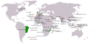
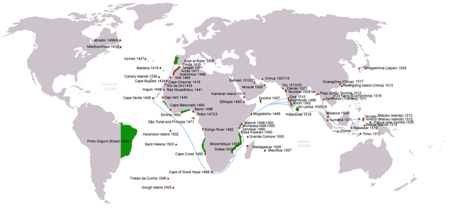
| تفصیل | Portuguese discoveries, exploration, contacts and conquests (from 1336 claim for Canary islands to 1543 Tanegashima arrival), arrival dates stated; main sea routes to the Indian Ocean (blue); Territories claimed under king John III of Portugal rule c.1536(green); English version |
| تاریخ | (UTC) |
| ماخذ | |
| مصنف | |
| اجازت (فائل کا دوبارہ استعمال) |
Creative Commons Attribution-Share Alike 3.0 Unported license |
| دوسرے نسخے | (pt) File:Descobrimentos e explorações portuguesesV2.png |
| This is a retouched picture, which means that it has been digitally altered from its original version. Modifications: english version. The original can be viewed here: Descobrimentos e explorações portuguesesV2.png:
|
میں اس تخلیقی کام کے حقوق کا مالک ہوں اور اسے مندرجہ ذیل اجازت نامے کے تحت شائع کرتا ہوں:

|
آپ کو آزاد سافٹ ویئر فاؤنڈیشن کی جانب سے شائع کردہ جی این یو آزاد مسوداتی اجازت نامہ کی شرائط استعمال کے تحت اس دستاویز کو نقل، تقسیم اور/ یا ترمیم کرنے کی اجازت دی جاتی ہے۔ اس اجازت نامہ کی ایک نقل 'جی این یو آزاد مسوداتی اجازت نامہ کے عنوان سے میسر ہے۔ |
| اس ملف کا لائسنس Creative Commons Attribution-Share Alike 3.0 Unported کے تحط ہے۔ | ||
| ||
| This licensing tag was added to this file as part of the GFDL licensing update. |
اولین اپلوڈ کا نوشتہ
This image is a derivative work of the following images:
- File:Descobrimentos_e_explorações_portuguesesV2.png licensed with GFDL
- 2009-06-07T18:23:47Z Uxbona 1357x628 (209965 Bytes) Reverted to version as of 16:09, 7 June 2009
- 2009-06-07T18:21:32Z Uxbona 1357x628 (208814 Bytes) English version
- 2009-06-07T16:09:30Z Uxbona 1357x628 (209965 Bytes) {{Information |Description=Portuguese discoveries and explorations, sea routes |Source=*[[:File:Descobrimentos_e_explorações_portugueses.png|]] |Date=2009-06-07 17:07 (UTC) |Author=*[[:File:Descobrimentos_e_explorações_po
Uploaded with derivativeFX
فائل کا تاریخچہ
کسی خاص وقت یا تاریخ میں یہ فائل کیسی نظر آتی تھی، اسے دیکھنے کے لیے اس وقت/تاریخ پر کلک کریں۔
| تاریخ/وقت | تھمب نیل | ابعاد | صارف | تبصرہ | |
|---|---|---|---|---|---|
| رائج الوقت | 13:26، 10 جون 2011ء | | 1,357 × 628 (213 کلوبائٹ) | Uxbona | (Included Da Nang/Cochinchina arrival c.1516 (See Li, Tana Li. Nguyễn Cochinchina: southern Vietnam in the seventeenth and eighteenth centuries. [S.l.]: SEAP Publications, 1998)) |
| 13:24، 10 جون 2011ء |  | 1,357 × 628 (213 کلوبائٹ) | Uxbona | Included Da Nang/Cochinchina arrival c.1516 (See Li, Tana Li. Nguyễn Cochinchina: southern Vietnam in the seventeenth and eighteenth centuries. [S.l.]: SEAP Publications, 1998) | |
| 20:48، 23 جنوری 2011ء |  | 1,357 × 628 (211 کلوبائٹ) | Micsha~commonswiki | Reverted to version as of 22:55, 6 May 2010 | |
| 20:48، 23 جنوری 2011ء |  | 816 × 447 (225 کلوبائٹ) | Micsha~commonswiki | Includes key and excludes the Americas | |
| 22:55، 6 مئی 2010ء |  | 1,357 × 628 (211 کلوبائٹ) | Uxbona | Gough island, Pegu and Sumatra added, Ayutthaya location corrected | |
| 22:25، 10 اپریل 2010ء |  | 1,357 × 628 (208 کلوبائٹ) | Uxbona | Reverted to version as of 22:14, 10 April 2010 | |
| 22:24، 10 اپریل 2010ء |  | 1,357 × 628 (208 کلوبائٹ) | Uxbona | (Updated data: Kamaran Island arrival, Nei Lingding Island arrival; Guangdong Arrival; Reduced depicted area of territorial influence in Africa after deletion request, guided by accepted maps (such as Iberian Union Empires.png)) | |
| 22:14، 10 اپریل 2010ء |  | 1,357 × 628 (208 کلوبائٹ) | Uxbona | Updated data: Kamaran Island arrival, Nei Lingding Island arrival; Guangdong Arrival; Reduced depicted area of territorial influence in Africa after deletion request, guided by accepted maps (such as Iberian Union Empires.png) | |
| 13:25، 6 اکتوبر 2009ء |  | 1,357 × 628 (207 کلوبائٹ) | Uxbona | updated with Tristan da Cunha island | |
| 10:08، 10 جون 2009ء |  | 1,357 × 628 (205 کلوبائٹ) | Uxbona | corrected data |
روابط
درج ذیل صفحہ اس فائل کو استعمال کر رہا ہے:
فائل کا عالمی استعمال
مندرجہ ذیل ویکیوں میں یہ فائل زیر استعمال ہے:
- ar.wikipedia.org پر استعمال
- azb.wikipedia.org پر استعمال
- az.wikipedia.org پر استعمال
- ca.wikipedia.org پر استعمال
- da.wikipedia.org پر استعمال
- de.wikipedia.org پر استعمال
- el.wikipedia.org پر استعمال
- en.wikipedia.org پر استعمال
- en.wikivoyage.org پر استعمال
- es.wikipedia.org پر استعمال
- fi.wikipedia.org پر استعمال
- fr.wikipedia.org پر استعمال
- hi.wikipedia.org پر استعمال
- hu.wikipedia.org پر استعمال
- io.wikipedia.org پر استعمال
- is.wikipedia.org پر استعمال
- it.wikipedia.org پر استعمال
- kaa.wikipedia.org پر استعمال
- lv.wikipedia.org پر استعمال
- mk.wikipedia.org پر استعمال
- mt.wikipedia.org پر استعمال
- nl.wikipedia.org پر استعمال
- pt.wikipedia.org پر استعمال
- ru.wikipedia.org پر استعمال
- sl.wikipedia.org پر استعمال
- tr.wikipedia.org پر استعمال
- uk.wikipedia.org پر استعمال
- uz.wikipedia.org پر استعمال
- vi.wikipedia.org پر استعمال
اس فائل کا مزید عالمی استعمال دیکھیے۔