فائل:Shepherd Map of Ancient Italy, Northern Part.jpg
اصل فائل (1,820 × 1,480 پکسل، فائل کا حجم: 1.21 MB، MIME قسم: image/jpeg)
خلاصہ
| تفصیل |
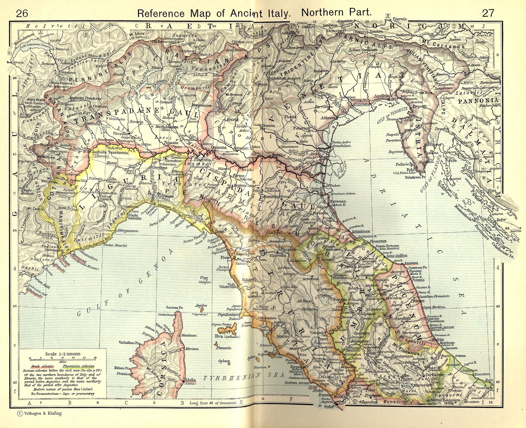
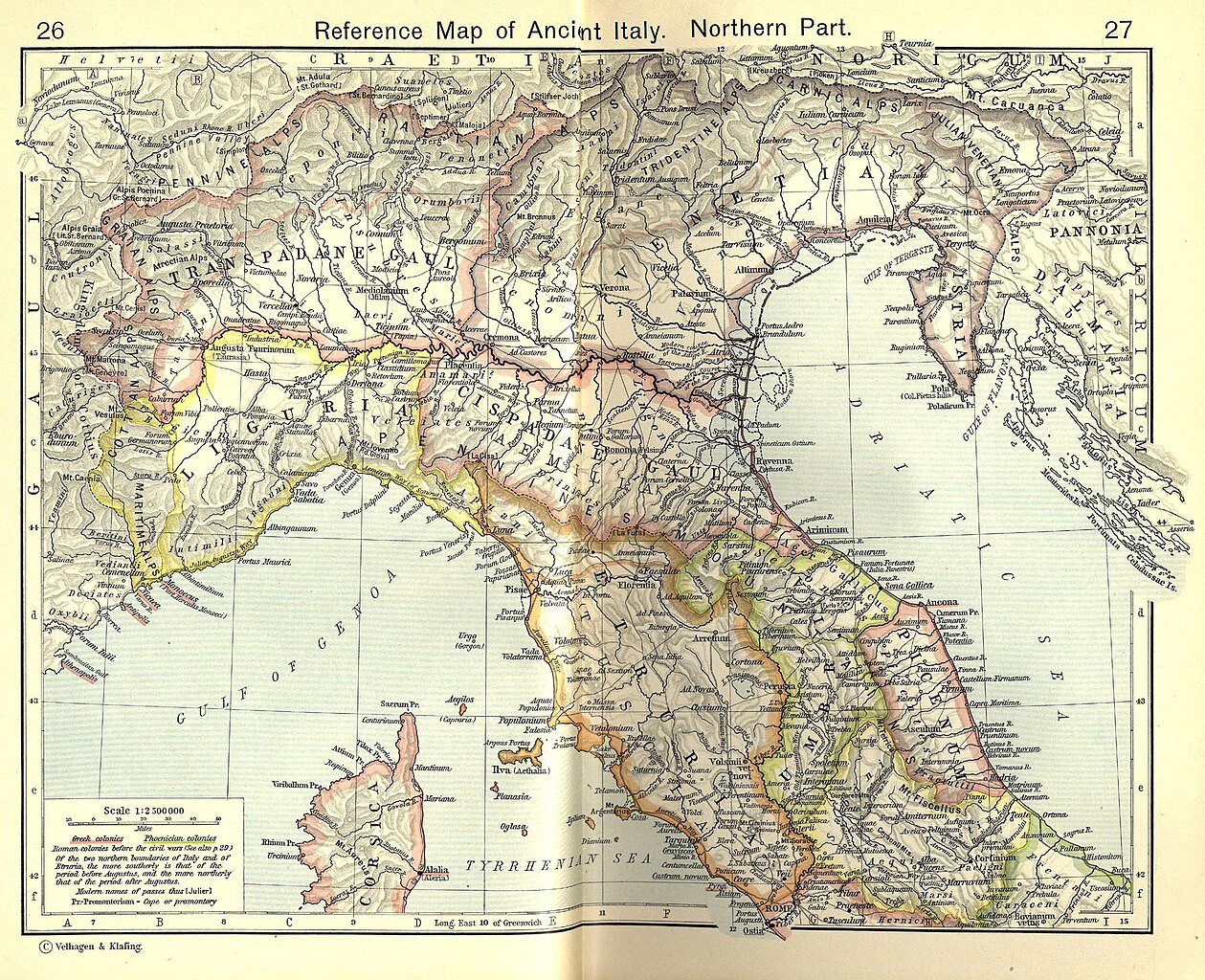
English: Reference Map of Ancient Italy, Northern Part [1]
Historical Atlas by William R. Shepherd, 1911. Courtesy of the University of Texas Libraries, The University of Texas at Austin. From The Historical Atlas by William R. Shepherd, 1911 edition |
| تاریخ | 7 مارچ 2008 (upload date) |
| ماخذ | Historical Atlas by William R. Shepherd 1911 edition |
| مصنف | Historical Atlas by William R. Shepherd 1911 edition |
| اجازت (فائل کا دوبارہ استعمال) |
This image is in the public domain due to its age. See also http://www.lib.utexas.edu/usage_statement.html?maps=yes |
| دوسرے نسخے | Derivative works of this file: Ancient Umbria.png |
![[1]](http://www.lib.utexas.edu/maps/historical/shepherd_1911/shepherd-c-026-027.jpg)
اجازہ کاری
|
This work is in the public domain in its country of origin and other countries and areas where the copyright term is the author's life plus 70 years or fewer.
| |
| This file has been identified as being free of known restrictions under copyright law, including all related and neighboring rights. | |
This media file is in the public domain in the United States. This applies to U.S. works where the copyright has expired, often because its first publication occurred prior to January 1, 1929, and if not then due to lack of notice or renewal. See this page for further explanation.
|
 | |
 |
This image might not be in the public domain outside of the United States; this especially applies in the countries and areas that do not apply the rule of the shorter term for US works, such as Canada, Mainland China (not Hong Kong or Macao), Germany, Mexico, and Switzerland. The creator and year of publication are essential information and must be provided. See Wikipedia:Public domain and Wikipedia:Copyrights for more details.
|
فائل کا تاریخچہ
کسی خاص وقت یا تاریخ میں یہ فائل کیسی نظر آتی تھی، اسے دیکھنے کے لیے اس وقت/تاریخ پر کلک کریں۔
| تاریخ/وقت | تھمب نیل | ابعاد | صارف | تبصرہ | |
|---|---|---|---|---|---|
| رائج الوقت | 18:52، 19 جولائی 2010ء | | 1,820 × 1,480 (1.21 MB) | Cropbot | upload cropped version, operated by User:Beao. Summary: cropped |
| 08:02، 1 جولائی 2007ء |  | 1,902 × 1,545 (831 کلوبائٹ) | Accurimbono | == Summary == Map of Northen Italy during the Roman period. Extracted from ''The Historical Atlas'' by William R. Shepherd, 1911. Original image is at http://www.lib.utexas.edu/maps/historical/shepherd_1911/shepherd-c-026-027.jpg [ |
روابط
درج ذیل صفحہ اس فائل کو استعمال کر رہا ہے:
فائل کا عالمی استعمال
مندرجہ ذیل ویکیوں میں یہ فائل زیر استعمال ہے:
- ast.wikipedia.org پر استعمال
- bg.wikipedia.org پر استعمال
- br.wikipedia.org پر استعمال
- ca.wikipedia.org پر استعمال
- cs.wikipedia.org پر استعمال
- de.wikipedia.org پر استعمال
- en.wikipedia.org پر استعمال
- es.wikipedia.org پر استعمال
- et.wikipedia.org پر استعمال
- fr.wikipedia.org پر استعمال
- it.wikipedia.org پر استعمال
اس فائل کا مزید عالمی استعمال دیکھیے۔