فائل:South-east frontier of France after the Treaty of Paris, 1814.jpg

اس نمائش کا حجم: 468 × 600 پکسلز۔ دیگر تصمیمات: 187 × 240 پکسلز | 374 × 480 پکسلز | 599 × 768 پکسلز | 799 × 1,024 پکسلز | 1,648 × 2,112 پکسلز۔
اصل فائل (1,648 × 2,112 پکسل، فائل کا حجم: 1.71 MB، MIME قسم: image/jpeg)
خلاصہ
| تفصیل |
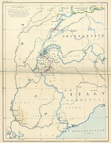
English: South-east frontier of France after the Treaty of Paris, 1814 |
| تاریخ | |
| ماخذ | Edward Hertslet (1875). The map of Europe by treaty; showing the various political and territorial changes which have taken place since the general peace of 1814, London, Butterworths. p. opposite 28, 351 |
| مصنف | Edward Hertslet; and Stafford's Geng Estab, 55 Charing Cross |
اجازہ کاری
|
This work is in the public domain in its country of origin and other countries and areas where the copyright term is the author's life plus 70 years or fewer. This work is in the public domain in the United States because it was published (or registered with the U.S. Copyright Office) before January 1, 1929. | |
| This file has been identified as being free of known restrictions under copyright law, including all related and neighboring rights. | |
فائل کا تاریخچہ
کسی خاص وقت یا تاریخ میں یہ فائل کیسی نظر آتی تھی، اسے دیکھنے کے لیے اس وقت/تاریخ پر کلک کریں۔
| تاریخ/وقت | تھمب نیل | ابعاد | صارف | تبصرہ | |
|---|---|---|---|---|---|
| رائج الوقت | 21:31، 3 ستمبر 2014ء | | 1,648 × 2,112 (1.71 MB) | PBS | User created page with UploadWizard |
روابط
درج ذیل صفحہ اس فائل کو استعمال کر رہا ہے:
فائل کا عالمی استعمال
مندرجہ ذیل ویکیوں میں یہ فائل زیر استعمال ہے:
- ar.wikipedia.org پر استعمال
- en.wikipedia.org پر استعمال
- es.wikipedia.org پر استعمال
- fr.wikipedia.org پر استعمال
- he.wikipedia.org پر استعمال
- it.wikipedia.org پر استعمال
- ja.wikipedia.org پر استعمال
- ka.wikipedia.org پر استعمال
- pnb.wikipedia.org پر استعمال
- pt.wikipedia.org پر استعمال
- pt.wikiquote.org پر استعمال
- sr.wikipedia.org پر استعمال
- tt.wikipedia.org پر استعمال
- uk.wikipedia.org پر استعمال