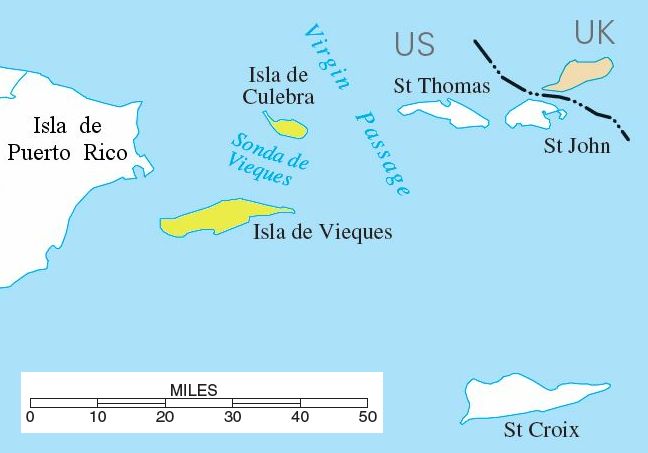
فائل:Spanish-virgin-islands.jpg
Spanish-virgin-islands.jpg (648 × 453 پکسل، فائل کا حجم: 30 کلوبائٹ، MIME قسم: image/jpeg)
فائل کا تاریخچہ
کسی خاص وقت یا تاریخ میں یہ فائل کیسی نظر آتی تھی، اسے دیکھنے کے لیے اس وقت/تاریخ پر کلک کریں۔
| تاریخ/وقت | تھمب نیل | ابعاد | صارف | تبصرہ | |
|---|---|---|---|---|---|
| رائج الوقت | 13:39، 10 اگست 2006ء |  | 648 × 453 (30 کلوبائٹ) | Eoghanacht | {{Information |Description= {{w|Spanish Virgin Islands}} with surrounding islands. {{coor dm|18|18|51|N|65|18|W|}}. |Source= National Atlas of the United States[http://nationalatlas.gov/printable/images/pdf/rivers/pagehyd_pr4.pdf] |Date= |Author= |Permiss |
روابط
درج ذیل صفحہ اس فائل کو استعمال کر رہا ہے:
فائل کا عالمی استعمال
مندرجہ ذیل ویکیوں میں یہ فائل زیر استعمال ہے:
- ar.wikipedia.org پر استعمال
- br.wikipedia.org پر استعمال
- da.wikipedia.org پر استعمال
- en.wikipedia.org پر استعمال
- eo.wikipedia.org پر استعمال
- es.wikipedia.org پر استعمال
- fa.wikipedia.org پر استعمال
- fr.wikipedia.org پر استعمال
- hr.wikipedia.org پر استعمال
- it.wikipedia.org پر استعمال
- ja.wikipedia.org پر استعمال
- ko.wikipedia.org پر استعمال
- lb.wikipedia.org پر استعمال
- nl.wikipedia.org پر استعمال
- no.wikipedia.org پر استعمال
- pnb.wikipedia.org پر استعمال
- pt.wikipedia.org پر استعمال
- ro.wikipedia.org پر استعمال
- ru.wikipedia.org پر استعمال
- ta.wikipedia.org پر استعمال
- uk.wikipedia.org پر استعمال
- www.wikidata.org پر استعمال
- zh.wikipedia.org پر استعمال


