فائل:Spice Islands (Zanzibar highlighted).svg

اس SVG فائل کی PNG نمائش کا حجم: 486 × 599 پکسلز دیگر تصمیمات: 195 × 240 پکسلز | 389 × 480 پکسلز | 623 × 768 پکسلز | 831 × 1,024 پکسلز | 1,662 × 2,048 پکسلز | 512 × 631 پکسلز۔
اصل فائل (ایس وی جی فائل، ابعاد 512 × 631 پکسل، فائل کا حجم: 6.08 MB)
.svg)
خلاصہ
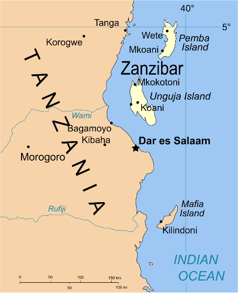
| تفصیل | Part of the map of Tanzania, showing the Spice Islands, and highlighting Zanzibar. |
| تاریخ | |
| ماخذ | Vectors self-made in Inkscape. Source was cropped from 2003 Political map of Tanzania at Perry-Castañeda Library Map Collection — Tanzania. The maps are attributed to the US Central Intelligence Agency. |
| مصنف | Mysid |
| دوسرے نسخے |
Derivative works of this file: Image:Spice Islands (Tanzania).svgin French : Image:Spice_Islands_Tanzania-fr.svg in French : Image:Spice_Islands-Zanzibar_highlighted-fr.svg in Arabic: Image:Spice Islands (Zanzibar highlighted)-ar.svg |
| SVG genesis |
_el.svg)
_sv.svg)
.svg)
-ar.svg)
اجازہ کاری
| میں اس تخلیقی کام کے حقوق کا مالک ہوں اور اسے دائرہ عام میں شائع کرتا ہوں جس کا اطلاق عالمی سطح پر ہوتا ہے۔ بعض ملکوں میں یہ قانونی طور پر شاید ممکن نہ ہو؛ اگر ایسا ہے تو: میں ہر ایک کو کسی بھی مقصد کے لیے بغیر کسی شرط کے اس تصویر کے استعمال کا حق تفویض کرتا/کرتی ہوں، بجز اس صورت کے جس میں کوئی قانونی رکاوٹ موجود ہو۔ |
فائل کا تاریخچہ
کسی خاص وقت یا تاریخ میں یہ فائل کیسی نظر آتی تھی، اسے دیکھنے کے لیے اس وقت/تاریخ پر کلک کریں۔
| تاریخ/وقت | تھمب نیل | ابعاد | صارف | تبصرہ | |
|---|---|---|---|---|---|
| رائج الوقت | 02:16، 9 اکتوبر 2021ء | | 512 × 631 (6.08 MB) | Nwbeeson | Zanzibar Island renamed to Unguja Island to match article caption |
| 20:09، 6 جنوری 2007ء |  | 713 × 879 (15 کلوبائٹ) | Mysid | higlighting Pemba as well | |
| 20:06، 6 جنوری 2007ء |  | 713 × 879 (15 کلوبائٹ) | Mysid | == Summary == {{Information |Description=Part of the map of Tanzania, showing the Spice Islands, and highlighting Zanzibar. |Source=Vectors self-made in Inkscape. Source was cropped from http://www.lib.utexas.edu/maps/africa/tanzania_p |
روابط
اس فائل سے مربوط کوئی صفحہ موجود نہیں ہے۔
فائل کا عالمی استعمال
مندرجہ ذیل ویکیوں میں یہ فائل زیر استعمال ہے:
- af.wikipedia.org پر استعمال
- ar.wikipedia.org پر استعمال
- ast.wikipedia.org پر استعمال
- ast.wiktionary.org پر استعمال
- azb.wikipedia.org پر استعمال
- az.wikipedia.org پر استعمال
- ba.wikipedia.org پر استعمال
- bg.wikipedia.org پر استعمال
- bn.wikipedia.org پر استعمال
- br.wikipedia.org پر استعمال
- ca.wikipedia.org پر استعمال
- cs.wikipedia.org پر استعمال
- de.wikipedia.org پر استعمال
- en.wikipedia.org پر استعمال
- eo.wikipedia.org پر استعمال
- eu.wikipedia.org پر استعمال
- fa.wikipedia.org پر استعمال
- fiu-vro.wikipedia.org پر استعمال
- fr.wikipedia.org پر استعمال
- gd.wikipedia.org پر استعمال
- gl.wikipedia.org پر استعمال
- ha.wikipedia.org پر استعمال
- hr.wikipedia.org پر استعمال
- hy.wikipedia.org پر استعمال
- id.wikipedia.org پر استعمال
- it.wikipedia.org پر استعمال
- it.wikivoyage.org پر استعمال
- ja.wikipedia.org پر استعمال
- ka.wikipedia.org پر استعمال
- ko.wikipedia.org پر استعمال
- ku.wikipedia.org پر استعمال
- lt.wikipedia.org پر استعمال
- lv.wikipedia.org پر استعمال
- mg.wikipedia.org پر استعمال
- nl.wikipedia.org پر استعمال
اس فائل کا مزید عالمی استعمال دیکھیے۔
.svg)
.svg)