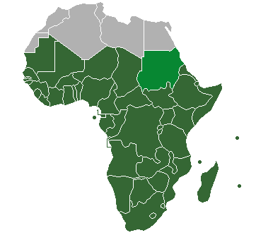
فائل:Sub-Saharan Africa definition UN.png
Sub-Saharan_Africa_definition_UN.png (362 × 340 پکسل، فائل کا حجم: 6 کلوبائٹ، MIME قسم: image/png)
فائل کا تاریخچہ
کسی خاص وقت یا تاریخ میں یہ فائل کیسی نظر آتی تھی، اسے دیکھنے کے لیے اس وقت/تاریخ پر کلک کریں۔
| تاریخ/وقت | تھمب نیل | ابعاد | صارف | تبصرہ | |
|---|---|---|---|---|---|
| رائج الوقت | 20:47، 19 جولائی 2013ء |  | 362 × 340 (6 کلوبائٹ) | Maproom | Reshaded South Sudan, which the UN now regards as in East Africa, not North Africa: see http://unstats.un.org/unsd/methods/m49/m49regin.htm |
| 13:27، 12 اپریل 2012ء |  | 362 × 340 (9 کلوبائٹ) | Hazhk | Adding different shading for Sudan & S. Sudan because they're also classified as being part of North Africa by the UN | |
| 22:02، 9 جولائی 2011ء |  | 356 × 344 (11 کلوبائٹ) | Maphobbyist | South Sudan has become independent on July 9, 2011. Sudan and South Sudan are shown with the new international border between them. | |
| 06:46، 31 مارچ 2011ء |  | 356 × 344 (10 کلوبائٹ) | Hoshie | added Cabinda (Angola) to map | |
| 11:18، 15 دسمبر 2010ء |  | 356 × 344 (6 کلوبائٹ) | Jcherlet | {{Information |Description=Definition of Sub-Saharan Africa, according to the United Nations institutions |Source=*File:HDImap_spectrum2006_Africa.png |Date=2010-12-15 11:13 (UTC) |Author=*Jcherlet: '''Jcherlet''' *derivative work: |
روابط
درج ذیل صفحہ اس فائل کو استعمال کر رہا ہے:
فائل کا عالمی استعمال
مندرجہ ذیل ویکیوں میں یہ فائل زیر استعمال ہے:
- ast.wikipedia.org پر استعمال
- ca.wikipedia.org پر استعمال
- ckb.wikipedia.org پر استعمال
- cs.wikipedia.org پر استعمال
- de.wikipedia.org پر استعمال
- en.wikipedia.org پر استعمال
- Sub-Saharan Africa
- Water supply and sanitation in sub-Saharan Africa
- Wikipedia:Reference desk/Archives/Humanities/2013 October 5
- Category:Birds of Sub-Saharan Africa
- Category:Fauna of Sub-Saharan Africa
- Category:Biota of Sub-Saharan Africa
- Category:Mammals of Sub-Saharan Africa
- User:DexDor/Categorization of organisms by geography
- Category:Moths of Sub-Saharan Africa
- Category:Amphibians of Sub-Saharan Africa
- et.wikipedia.org پر استعمال
- ha.wikipedia.org پر استعمال
- he.wikipedia.org پر استعمال
- id.wikipedia.org پر استعمال
- ig.wikipedia.org پر استعمال
- ilo.wikipedia.org پر استعمال
- it.wikipedia.org پر استعمال
- ja.wikipedia.org پر استعمال
- ka.wikipedia.org پر استعمال
- ko.wikipedia.org پر استعمال
- lt.wikipedia.org پر استعمال
- pa.wikipedia.org پر استعمال
- pnb.wikipedia.org پر استعمال
- ro.wikipedia.org پر استعمال
- simple.wikipedia.org پر استعمال
- sr.wikipedia.org پر استعمال
- sv.wikipedia.org پر استعمال
- ta.wikipedia.org پر استعمال
- th.wikipedia.org پر استعمال
- tn.wikipedia.org پر استعمال
- tr.wikipedia.org پر استعمال
اس فائل کا مزید عالمی استعمال دیکھیے۔

