فائل:Tibet provinces.png
اس نمائش کا حجم: 800 × 555 پکسلز۔ دیگر تصمیمات: 320 × 222 پکسلز | 640 × 444 پکسلز | 1,024 × 711 پکسلز | 1,421 × 986 پکسلز۔
اصل فائل (1,421 × 986 پکسل، فائل کا حجم: 871 کلوبائٹ، MIME قسم: image/png)
| تفصیل |
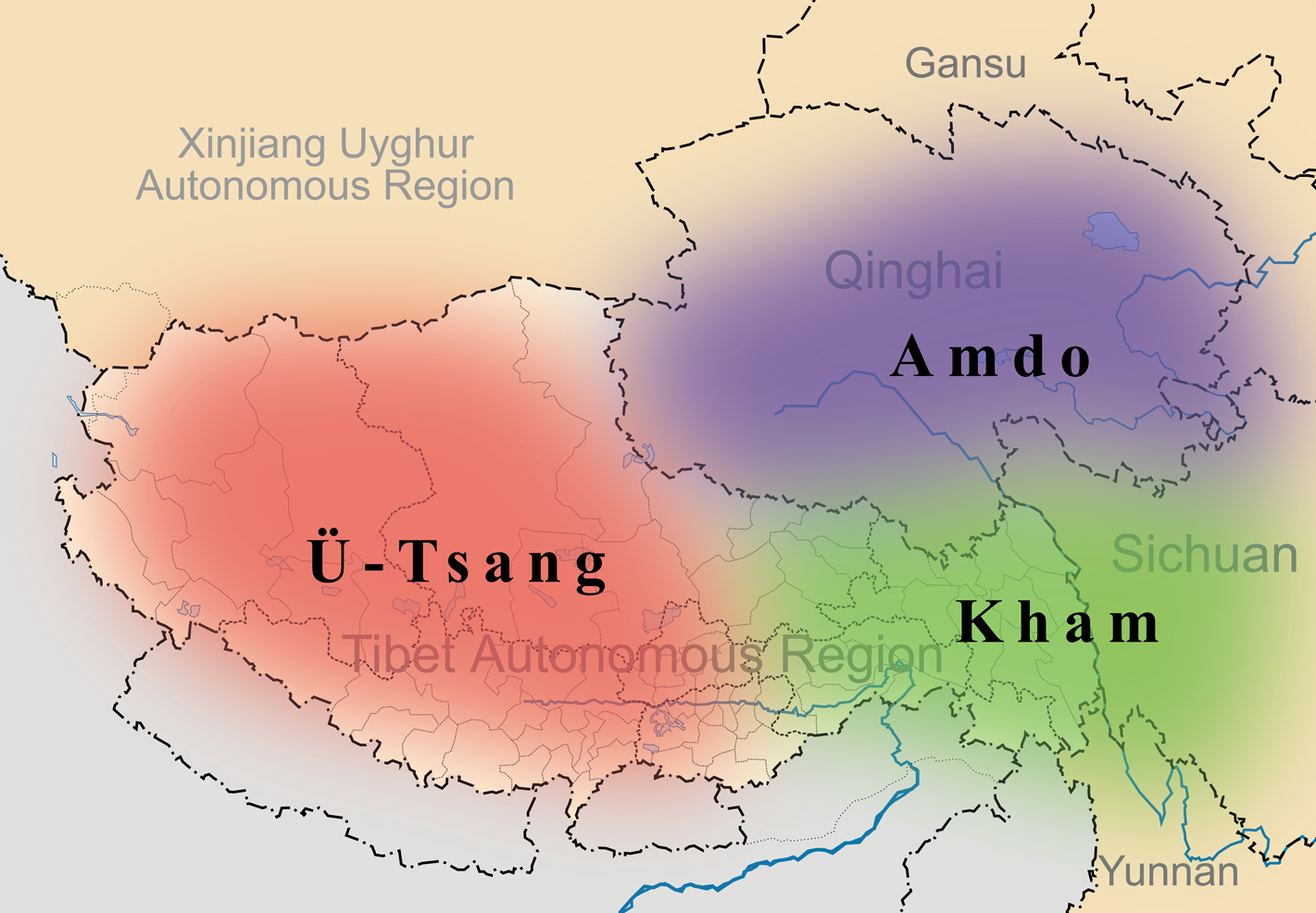
English: A simple map of the three traditional provinces of Tibet overlaid on a map of modern provincial boundaries of the People's Republic of China. |
| تاریخ | (UTC) |
| ماخذ | |
| مصنف |
|
| This is a retouched picture, which means that it has been digitally altered from its original version. Modifications: added traditional provinces overlay. The original can be viewed here: Map of Tibet Ü-Tsang Amdo and Kham.jpg:
|
اس ملف کا لائسنس Creative Commons Attribution-Share Alike 3.0 Unported کے تحط ہے۔
- آپ آزاد ہیں:
- شیئر کرنے – کام کو نقل، تقسیم یا منتقل کرنے کے لیے
- ریمکس کے لیے – کام منبطق کرنے کے لیے
- مندرجہ ذیل شرائط کے تحت:
- انتساب – آپ کو اس کام کا انتساب مصنف یا اجازت دہندہ کے بتائے گئے طریقہ کے مطابق دینا ہوگا (تاہم یہ انتساب اس طرح نہیں ہونا چاہیے کہ اسے دیکھ کر ایسا محسوس ہو کہ اصل مصنف یا اجازت دہندہ آپ کے یا آپ کے ذریعہ اس کام کے استعمال کرنے کے حامی ہیں)۔
- یکساں شراکت – اگر آپ اس کام میں کوئی تبدیلی یا ترمیم کرتے ہیں یا اس کام پر مبنی کچھ نیا بناتے ہیں تو اسے بھی آپ اسی یا اس جیسے کسی اجازت نامے کے تحت شائع کر سکتے ہیں۔
اولین اپلوڈ کا نوشتہ
This image is a derivative work of the following images:
- File:Tibet&neighbors_Locator_map.svg licensed with Cc-by-sa-3.0, GFDL
- 2009-10-13T22:22:54Z Keithonearth 1520x1059 (188220 Bytes) {{Information |Description={{en|1=A simple map of the Tibetan Autonomous Region, and surrounding Nations, and States. It was made for [[:en:Template:Location map China Tibet]].}} |Source={{own}} |Author=[[User:Keithonearth|K
- File:Map_of_Tibet_Ü-Tsang_Amdo_and_Kham.jpg licensed with Cc-by-sa-2.5
Uploaded with derivativeFX
فائل کا تاریخچہ
کسی خاص وقت یا تاریخ میں یہ فائل کیسی نظر آتی تھی، اسے دیکھنے کے لیے اس وقت/تاریخ پر کلک کریں۔
| تاریخ/وقت | تھمب نیل | ابعاد | صارف | تبصرہ | |
|---|---|---|---|---|---|
| رائج الوقت | 21:35، 27 مارچ 2011ء | | 1,421 × 986 (871 کلوبائٹ) | Kmusser | {{Information |Description={{en|1=A simple map of the three traditional provinces of Tibet overlaid on a map of modern provincial boundaries of the People's Republic of China.}} == |Source=*File:Tibet&neighbors_Locator_map.svg *[[:File:Map_of_Tibet_ |
روابط
درج ذیل صفحہ اس فائل کو استعمال کر رہا ہے:
فائل کا عالمی استعمال
مندرجہ ذیل ویکیوں میں یہ فائل زیر استعمال ہے:
- ast.wikipedia.org پر استعمال
- bg.wikipedia.org پر استعمال
- bn.wikipedia.org پر استعمال
- cdo.wikipedia.org پر استعمال
- cs.wikipedia.org پر استعمال
- da.wikipedia.org پر استعمال
- de.wikipedia.org پر استعمال
- diq.wikipedia.org پر استعمال
- en.wikipedia.org پر استعمال
- en.wikivoyage.org پر استعمال
- en.wiktionary.org پر استعمال
- eo.wikipedia.org پر استعمال
- es.wikipedia.org پر استعمال
- et.wikipedia.org پر استعمال
- eu.wikipedia.org پر استعمال
- fa.wikipedia.org پر استعمال
- fr.wikipedia.org پر استعمال
- fr.wiktionary.org پر استعمال
- ga.wikipedia.org پر استعمال
- hi.wikipedia.org پر استعمال
- hu.wikipedia.org پر استعمال
اس فائل کا مزید عالمی استعمال دیکھیے۔