فائل:USA territorial growth.gif

اس نمائش کا حجم: 800 × 498 پکسلز۔ دیگر تصمیمات: 320 × 199 پکسلز | 640 × 398 پکسلز | 921 × 573 پکسلز۔
اصل فائل (921 × 573 پکسل، فائل کا حجم: 2.01 MB، MIME قسم: image/gif، چکردار، 10 چوکھٹے، 50 سیکنڈ)
خلاصہ
| تفصیل |
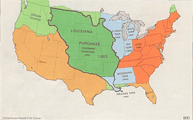
English: US territorial growth 1810–1920, based on the PD USGS maps in Category:Territorial growth maps of the United States.
See key below for explanation of colors.  |
||||||
| ماخذ |
|
||||||
| مصنف |
|
||||||
| دوسرے نسخے |
|

اجازہ کاری
This image is in the public domain in the United States because it only contains materials that originally came from the United States Geological Survey, an agency of the United States Department of the Interior. For more information, see the official USGS copyright policy.
|
فائل کا تاریخچہ
کسی خاص وقت یا تاریخ میں یہ فائل کیسی نظر آتی تھی، اسے دیکھنے کے لیے اس وقت/تاریخ پر کلک کریں۔
| تاریخ/وقت | تھمب نیل | ابعاد | صارف | تبصرہ | |
|---|---|---|---|---|---|
| رائج الوقت | 01:39، 31 مئی 2006ء | | 921 × 573 (2.01 MB) | Roke~commonswiki | longer interval, 3 seconds --> 5 seconds |
| 12:21، 30 مئی 2006ء |  | 921 × 573 (2.67 MB) | Roke~commonswiki | US territorial growth 1810-1920, based on the USGS maps in commons:Category:USA Territorial Growth Maps, put together in Corel Painter IX. The individual maps have this licence: {{PD-USGov-USGS}} If it is necessary for me to licence my contributio |
روابط
درج ذیل صفحہ اس فائل کو استعمال کر رہا ہے:
فائل کا عالمی استعمال
مندرجہ ذیل ویکیوں میں یہ فائل زیر استعمال ہے:
- bn.wikipedia.org پر استعمال
- en.wikipedia.org پر استعمال
- es.wikipedia.org پر استعمال
- fa.wikipedia.org پر استعمال
- fy.wikipedia.org پر استعمال
- ha.wikipedia.org پر استعمال
- he.wikipedia.org پر استعمال
- nl.wikipedia.org پر استعمال
- pnb.wikipedia.org پر استعمال
- ru.wikipedia.org پر استعمال
- ru.wikinews.org پر استعمال
- sr.wikipedia.org پر استعمال
- tr.wikipedia.org پر استعمال
- uz.wikipedia.org پر استعمال
- www.wikidata.org پر استعمال