فائل:US landings.jpg
اس نمائش کا حجم: 800 × 562 پکسلز۔ دیگر تصمیمات: 320 × 225 پکسلز | 640 × 449 پکسلز | 1,024 × 719 پکسلز | 1,280 × 899 پکسلز | 1,995 × 1,401 پکسلز۔
اصل فائل (1,995 × 1,401 پکسل، فائل کا حجم: 1.11 MB، MIME قسم: image/jpeg)
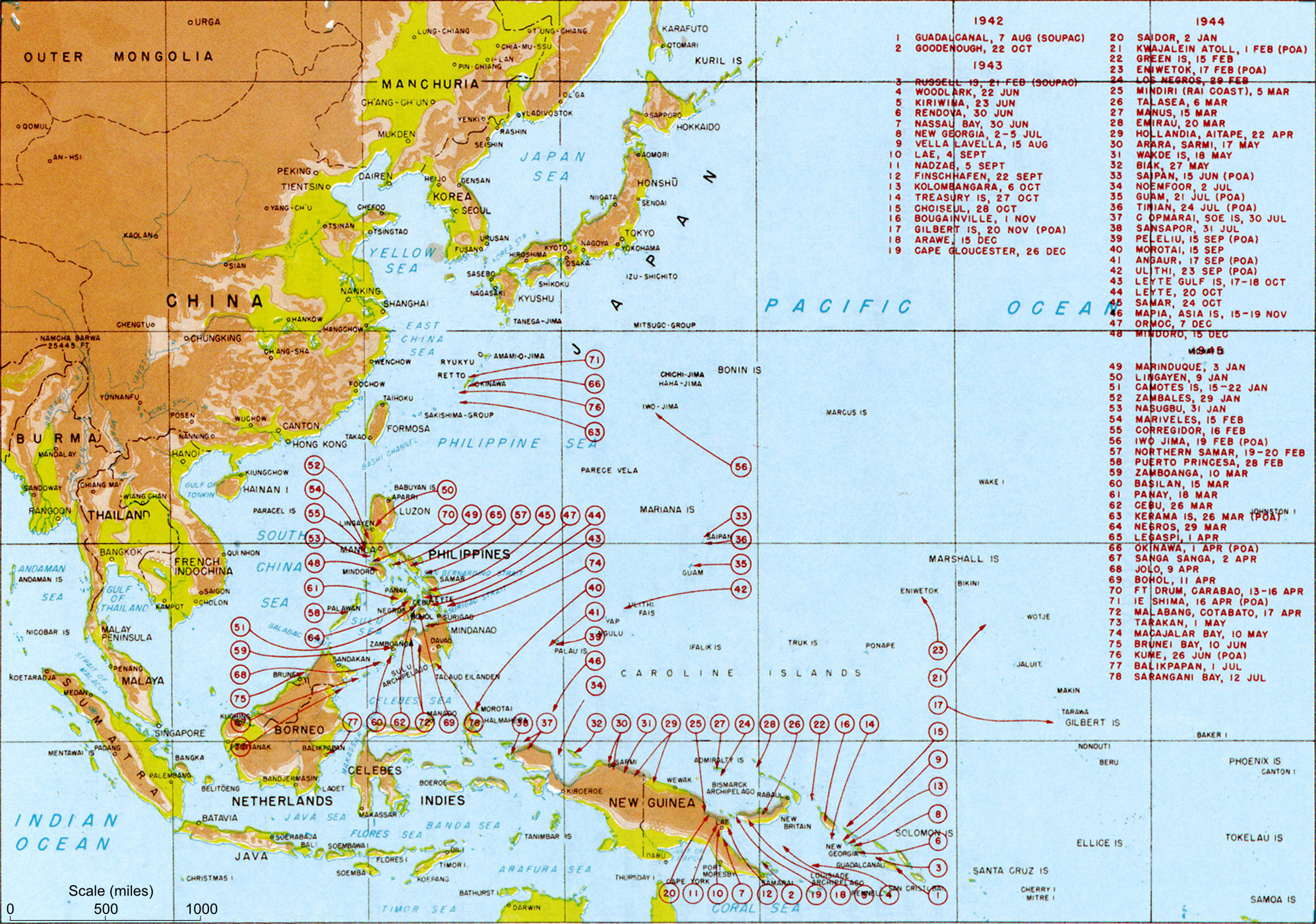
| تفصیل | Map titled "Allied landings — August 1942 to August 1945", plate #126. It should be noted that while the title of the image is "US Landings" the map also indicates the position of many landings by Australian troops (at least) so should be referred to as "Allied landings". | |||
| تاریخ | قریباً 1950 | |||
| ماخذ | MacArthur, Douglas (1994) [1950] Reports of General MacArthur، Vol. 1، Center of Military History، pp. p. 432. Archived from the original on 12 فروری 2009. Retrieved on 24 فروری 2009. | |||
| مصنف | General MacArthur's General Staff | |||
| اجازت (فائل کا دوبارہ استعمال) |
|
|||
| دوسرے نسخے |
Derivative works of this file: US landings saipan.jpg
|


Transfer log
- Transfered from Wikipedia image of same name. Text above copied from Wikipedia. Performed by Mak 21:58, 29 May 2006 (UTC)
فائل کا تاریخچہ
کسی خاص وقت یا تاریخ میں یہ فائل کیسی نظر آتی تھی، اسے دیکھنے کے لیے اس وقت/تاریخ پر کلک کریں۔
| تاریخ/وقت | تھمب نیل | ابعاد | صارف | تبصرہ | |
|---|---|---|---|---|---|
| رائج الوقت | 18:51، 21 فروری 2010ء | | 1,995 × 1,401 (1.11 MB) | Raul654 | Added scale to map (using Darwin-Makassar distance as 925 miles, per web sources) |
| 05:31، 24 فروری 2009ء |  | 1,995 × 1,401 (1.37 MB) | Jappalang | Clearer map taken from the US Army site | |
| 21:58، 29 مئی 2006ء |  | 2,000 × 1,363 (437 کلوبائٹ) | Makthorpe | Allied landings - August 1942 to August 1945 Source: Scanned from Reports of General MacArthur (1994 facsimile printing), Vol 1. Plate #126 Category:World War II (pacific) Category: WWII maps (Pacific) License: Official US government document - |
روابط
درج ذیل صفحہ اس فائل کو استعمال کر رہا ہے:
فائل کا عالمی استعمال
مندرجہ ذیل ویکیوں میں یہ فائل زیر استعمال ہے:
- ar.wikipedia.org پر استعمال
- ast.wikipedia.org پر استعمال
- azb.wikipedia.org پر استعمال
- az.wikipedia.org پر استعمال
- bg.wikipedia.org پر استعمال
- bjn.wikipedia.org پر استعمال
- br.wikipedia.org پر استعمال
- bs.wikipedia.org پر استعمال
- ca.wikipedia.org پر استعمال
- cs.wikipedia.org پر استعمال
- da.wikipedia.org پر استعمال
- el.wikipedia.org پر استعمال
- en.wikipedia.org پر استعمال
- es.wikipedia.org پر استعمال
- et.wikipedia.org پر استعمال
- eu.wikipedia.org پر استعمال
- fa.wikipedia.org پر استعمال
- fi.wikipedia.org پر استعمال
- fr.wikipedia.org پر استعمال
- Seconde Guerre mondiale
- Discussion:Guerre du Pacifique
- Discussion utilisateur:Archeos/Discussions de salle de rédaction
- Discussion Projet:Seconde Guerre mondiale/Archive 2006
- Discussion utilisateur:Lilliputien/Renseignements généraux/RAZ
- Discussion Projet:Histoire militaire/Archive 2006
- Utilisateur:Pontauxchats/Archives Pontauxchats 9
- Discussion utilisateur:L'amateur d'aéroplanes/Archive1
- Discussion Projet:Seconde Guerre mondiale/Archive 1
- Capitulation du Japon
- ha.wikipedia.org پر استعمال
- he.wikipedia.org پر استعمال
- hr.wikipedia.org پر استعمال
- hu.wikipedia.org پر استعمال
- hy.wikipedia.org پر استعمال
- id.wikipedia.org پر استعمال
- it.wikipedia.org پر استعمال
- ka.wikipedia.org پر استعمال
- lt.wikipedia.org پر استعمال
- ml.wikipedia.org پر استعمال
اس فائل کا مزید عالمی استعمال دیکھیے۔