فائل:Zealandia topography.jpg

اس نمائش کا حجم: 516 × 600 پکسلز۔ دیگر تصمیمات: 206 × 240 پکسلز | 413 × 480 پکسلز | 661 × 768 پکسلز | 881 × 1,024 پکسلز | 1,391 × 1,617 پکسلز۔
اصل فائل (1,391 × 1,617 پکسل، فائل کا حجم: 1.34 MB، MIME قسم: image/jpeg)
خلاصہ
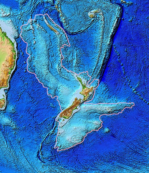
| تفصیل | Topographical map of the Zealandia continent. |
| تاریخ | |
| ماخذ | Ultimate source: ETOPO2v2, a digital database of seafloor and land elevations. Actually cropped from Image:Pacific_elevation.jpg. |
| مصنف | World Data Center for Geophysics & Marine Geology (Boulder, CO), National Geophysical Data Center, NOAA |
| اجازت (فائل کا دوبارہ استعمال) |
NOAA, public domain |
| دوسرے نسخے | Image:Pacific_elevation.jpg, here cropped to focus on Zealandia. |
اجازہ کاری
This image is in the public domain because it contains materials that originally came from the U.S. National Oceanic and Atmospheric Administration, taken or made as part of an employee's official duties.
|
فائل کا تاریخچہ
کسی خاص وقت یا تاریخ میں یہ فائل کیسی نظر آتی تھی، اسے دیکھنے کے لیے اس وقت/تاریخ پر کلک کریں۔
| تاریخ/وقت | تھمب نیل | ابعاد | صارف | تبصرہ | |
|---|---|---|---|---|---|
| رائج الوقت | 13:24، 28 مارچ 2017ء | | 1,391 × 1,617 (1.34 MB) | Bogomolov.PL | continent limits with pink |
| 01:44، 13 مارچ 2007ء |  | 573 × 677 (143 کلوبائٹ) | Avenue | == Summary == {{Information |Description=Topographical map of the Zealandia continent. |Source=Source: [http://www.ngdc.noaa.gov/mgg/image/2minrelief.html]. Actually cropped from Image:Pacific_elevation.jpg. |Date=June 2006 |Permissio |
روابط
درج ذیل صفحہ اس فائل کو استعمال کر رہا ہے:
فائل کا عالمی استعمال
مندرجہ ذیل ویکیوں میں یہ فائل زیر استعمال ہے:
- af.wikipedia.org پر استعمال
- ang.wikipedia.org پر استعمال
- ar.wikipedia.org پر استعمال
- ast.wikipedia.org پر استعمال
- az.wikipedia.org پر استعمال
- bg.wikipedia.org پر استعمال
- bn.wikipedia.org پر استعمال
- ca.wikipedia.org پر استعمال
- el.wikipedia.org پر استعمال
- en.wikipedia.org پر استعمال
- eo.wikipedia.org پر استعمال
- es.wikipedia.org پر استعمال
- et.wikipedia.org پر استعمال
- eu.wikipedia.org پر استعمال
- fa.wikipedia.org پر استعمال
- fi.wikipedia.org پر استعمال
- fr.wikipedia.org پر استعمال
- gl.wikipedia.org پر استعمال
- he.wikipedia.org پر استعمال
- hi.wikipedia.org پر استعمال
- hr.wikipedia.org پر استعمال
- hu.wikipedia.org پر استعمال
- hy.wikipedia.org پر استعمال
- ia.wikipedia.org پر استعمال
- id.wikipedia.org پر استعمال
- incubator.wikimedia.org پر استعمال
- is.wikipedia.org پر استعمال
- it.wikipedia.org پر استعمال
- ja.wikipedia.org پر استعمال
- ka.wikipedia.org پر استعمال
- kk.wikipedia.org پر استعمال
- ko.wikipedia.org پر استعمال
- li.wikipedia.org پر استعمال
اس فائل کا مزید عالمی استعمال دیکھیے۔