فائل:1640 Map of Formosa-Taiwan by Dutch 荷蘭人所繪福爾摩沙-臺灣.jpg

اس نمائش کا حجم: 800 × 552 پکسلز۔ دیگر تصمیمات: 320 × 221 پکسلز | 640 × 442 پکسلز | 1,024 × 707 پکسلز | 1,280 × 884 پکسلز | 2,560 × 1,768 پکسلز | 8,168 × 5,640 پکسلز۔
اصل فائل (8,168 × 5,640 پکسل، فائل کا حجم: 9.77 MB، MIME قسم: image/jpeg)
خلاصہ
| تفصیل |
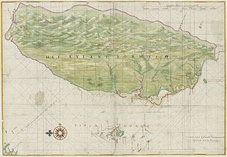
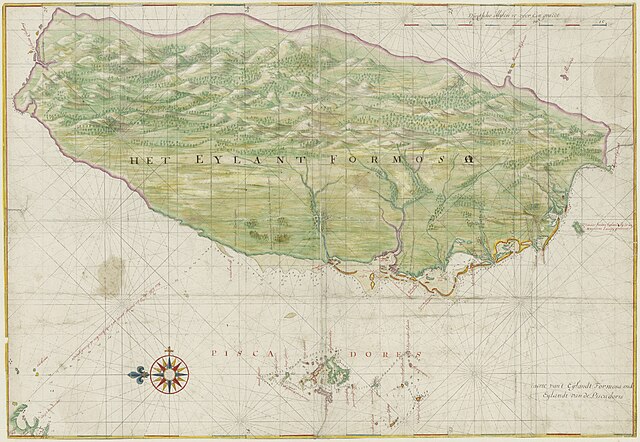
English: The Island Formosa and the Pescadores |
||||||||||||||||||||||
| تاریخ | قریباً 1640 | ||||||||||||||||||||||
| ماخذ | Nationaal Archief, Den Haag source. Copied from Chinese Wikipedia. Original source: npm.gov.tw | ||||||||||||||||||||||
| مصنف |
|
||||||||||||||||||||||
| اجازت (فائل کا دوبارہ استعمال) |
|
||||||||||||||||||||||
| دوسرے نسخے |
|
||||||||||||||||||||||


This is an image from the Nationaal Archief, the Dutch National Archives, donated in the context of a partnership program. This tag does not indicate the copyright status of the attached work. A normal copyright tag is still required. See Commons:Licensing.
|
فائل کا تاریخچہ
کسی خاص وقت یا تاریخ میں یہ فائل کیسی نظر آتی تھی، اسے دیکھنے کے لیے اس وقت/تاریخ پر کلک کریں۔
| تاریخ/وقت | تھمب نیل | ابعاد | صارف | تبصرہ | |
|---|---|---|---|---|---|
| رائج الوقت | 01:13، 11 نومبر 2021ء | | 8,168 × 5,640 (9.77 MB) | Tiouraren | Retrieve the rotation since the author had intentionally used this perspective, including labels and mountains. Such direction can also be seen in subsequent maps in Qing era. |
| 02:00، 3 نومبر 2021ء |  | 5,632 × 8,168 (9.96 MB) | SteinsplitterBot | Bot: Image rotated by 90° | |
| 09:27، 11 اکتوبر 2016ء |  | 8,168 × 5,640 (9.77 MB) | Timmietovenaar | Original high-res download from Nationaal Archief http://proxy.handle.net/10648/af87c7ee-d0b4-102d-bcf8-003048976d84 | |
| 21:59، 18 جون 2013ء |  | 1,266 × 876 (358 کلوبائٹ) | Wildcursive | clearer image | |
| 20:38، 13 اپریل 2012ء |  | 1,280 × 886 (325 کلوبائٹ) | Fentener van Vlissingen | higher resolution | |
| 16:47، 27 نومبر 2004ء |  | 600 × 412 (141 کلوبائٹ) | Wdshu | {{PD}} |
روابط
درج ذیل صفحہ اس فائل کو استعمال کر رہا ہے:
فائل کا عالمی استعمال
مندرجہ ذیل ویکیوں میں یہ فائل زیر استعمال ہے:
- af.wikipedia.org پر استعمال
- ar.wikipedia.org پر استعمال
- ca.wikipedia.org پر استعمال
- cs.wikipedia.org پر استعمال
- de.wikipedia.org پر استعمال
- en.wikipedia.org پر استعمال
- Dutch East India Company
- History of Taiwan
- Republic of Formosa
- History of Taiwan (1945–present)
- Fort Zeelandia (Taiwan)
- Fort Santo Domingo
- Dutch Formosa
- Kingdom of Tungning
- Francis Ferdinand de Capillas
- List of rulers of Taiwan
- François Caron
- Pieter Nuyts
- Portal:Taiwan
- Frederick Coyett
- User:DownUnder555/sandbox/History of Taiwan
- Taiwan under Japanese rule
- Prehistory of Taiwan
- Taiwan under Qing rule
- User:Jerrch/Sandbox
- History of Taipei
- History of education in Taiwan
- Siege of Fort Zeelandia
- Governor of Formosa
- Kingdom of Middag
- Economic history of Taiwan
اس فائل کا مزید عالمی استعمال دیکھیے۔