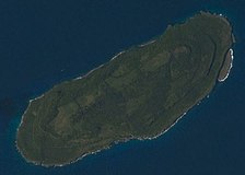
فائل:Aguijan ISS017-E-20419.JPG

اصل فائل (1,280 × 1,024 پکسل، فائل کا حجم: 79 کلوبائٹ، MIME قسم: image/jpeg)
یہ فائل ویکی ذخائر کی ہے اور دیگر منصوبوں کے زیر استعمال ہوسکتی ہے۔ فائل کے صفحہ تعارف پر موجود تعارف ذیل میں موجود ہے۔
خلاصہ
| تفصیلAguijan ISS017-E-20419.JPG |
Polski: Wyspa Aguijan w archipalegu Marianów Północnych
English: Aguijan Island, one of the Northern Mariana Islands |
||
| تاریخ | |||
| ماخذ | ISS017-E-20419 | ||
| مصنف | NASA | ||
| دوسرے نسخے |
|
| Camera location | 14° 48′ 00″ N, 145° 36′ 00″ E | View this and other nearby images on: OpenStreetMap |
|---|
This image or video was catalogued by one of the centers of the United States National Aeronautics and Space Administration (NASA) under Photo ID: ISS017-E-20419. This tag does not indicate the copyright status of the attached work. A normal copyright tag is still required. See Commons:Licensing. Other languages:
العربية ∙ беларуская (тарашкевіца) ∙ български ∙ català ∙ čeština ∙ dansk ∙ Deutsch ∙ English ∙ español ∙ فارسی ∙ français ∙ galego ∙ magyar ∙ հայերեն ∙ Bahasa Indonesia ∙ italiano ∙ 日本語 ∙ македонски ∙ മലയാളം ∙ Nederlands ∙ polski ∙ português ∙ русский ∙ sicilianu ∙ slovenščina ∙ Türkçe ∙ українська ∙ 简体中文 ∙ 繁體中文 ∙ +/− |
اجازہ کاری
| Public domainPublic domainfalsefalse |
| This file is in the public domain in the United States because it was solely created by NASA. NASA copyright policy states that "NASA material is not protected by copyright unless noted". (See Template:PD-USGov, NASA copyright policy page or JPL Image Use Policy.) |  | |
 |
Warnings:
|
Captions
Items portrayed in this file
عکاسی
21 اکتوبر 2008
coordinates of the point of view انگریزی
14°48'N, 145°36'E
media type انگریزی
image/jpeg
checksum انگریزی
4c8ce17de0bdc1d545df179910b311795818e900
data size انگریزی
81,251 لکمہ
1,024 عکصر
1,280 عکصر
فائل کا تاریخچہ
کسی خاص وقت یا تاریخ میں یہ فائل کیسی نظر آتی تھی، اسے دیکھنے کے لیے اس وقت/تاریخ پر کلک کریں۔
| تاریخ/وقت | تھمب نیل | ابعاد | صارف | تبصرہ | |
|---|---|---|---|---|---|
| رائج الوقت | 18:58، 25 فروری 2016ء |  | 1,280 × 1,024 (79 کلوبائٹ) | Szczureq | User created page with UploadWizard |
روابط
اس فائل سے مربوط کوئی صفحہ موجود نہیں ہے۔
فائل کا عالمی استعمال
مندرجہ ذیل ویکیوں میں یہ فائل زیر استعمال ہے:
- pl.wikipedia.org پر استعمال
- sv.wikipedia.org پر استعمال
میٹا ڈیٹا
اِس فائل میں اِضافی معلومات شامل ہیں، جو شاید اُس ڈیجیٹل کیمرے یا اِسکینر سے آئی ہیں جس کے ذریعے یہ فائل بنائی گئی تھی۔
اگر فائل اپنی اصل حالت میں نہ ہو تو کچھ معلومات ترمیم شدہ فائل کی مکمل طور پر عکاسی نہیں کر پائیں گی۔
| کیمرا ساز کمپنی | NIKON CORPORATION |
|---|---|
| کیمرے کا ماڈل | NIKON D2Xs |
| نمائش کا وقت | 1/640 سیکنڈ (0.0015625) |
| ایف نمبر | f/4.5 |
| آئیسو کی رفتار کی درجہ بندی | 200 |
| ڈیٹا تیار کرنے کی تاریخ اور وقت | 05:30، 21 اکتوبر 2008ء |
| عدسہ کی ماسکی لمبائی | 400 mm |
| چوڑائی | 3,072 لک |
| لمبائی | 2,098 لک |
| بٹ فی جزو |
|
| نظام کمپریشن | غیر کمپریس شدہ |
| پکسل کی ترکیب | RGB |
| جہت | عام |
| اجزا کی تعداد | 3 |
| افقی ریزولوشن | 300 dpi |
| عمودی ریزولیشن | 300 dpi |
| ڈیٹا کی ترتیب | دبیز فامیٹ |
| مستعمل مصنع لطیف | Adobe Photoshop CS3 Windows |
| فائل کی تبدیلی کی تاریخ اور وقت | 08:02، 23 اکتوبر 2008ء |
| نمائش کا پروگرام | اپرچر کی ترجیح |
| اکزیف ورژن | 2.21 |
| عددی نگارش کی تاریخ اور وقت | 05:30، 21 اکتوبر 2008ء |
| APEX شٹر کی رفتار | 9.321928 |
| APEX اپرچر | 4.33985 |
| APEX نمائش کا نقص | 0 |
| زیادہ سے زیادہ لینڈ اپرچر | 3 APEX (f/2.83) |
| پیمائش کاری کی حالت | طرز |
| روشنی کا ماخذ | نامعلوم |
| فلیش | فلیش نہیں چلا |
| صارف کے تبصرے |
|
| تاریخ و وقت کے ذیلی سیکنڈ | 31 |
| اصل تاریخ و وقت کے ذیلی سیکنڈ | 31 |
| ڈیجیٹل وقت و تاریخ کے ذیلی سیکنڈ | 31 |
| رنگ فضا | sRGB |
| سینسنگ کا طریقہ | علاقہ کی یک تراشہ رنگی کا سینسر |
| فائل کا ماخذ | ڈیجیٹل اسٹل کیمرا |
| منظر کی نوعیت | براہ راست کھینچی گئی تصویر |
| تصویر کی شخصی پروسیسینگ | عام عمل |
| نمائش کی حالت | خودکار نمائش |
| وائٹ بیلنس | سفید رنگ کا خودکار توازن |
| ڈیجیٹل زوم کا تناسب | 1 |
| 35 ایم ایم کی فلم میں ماسکی لمبائی | 600 mm |
| منظر کے گرفت کی نوعیت | معیاری |
| منظر کنٹرول | کچھ نہیں |
| امتیاز | نرم |
| پُری | عام |
| تیزی | عام |
| شئی کے فاصلے کی حد | نامعلوم |
| تصویر کی چوڑائی | 3,072 لک |
| تصویر کی لمبائی | 2,098 لک |
| کیمرے کا نمبر شمار | 6027233 |
| زیر استعمال عدسے | 400.0 mm f/2.8 |
| درجہ بندی (5 میں سے) | 0 |
| میٹاڈیٹا میں تبدیلی کی آخری تاریخ | 03:02، 23 اکتوبر 2008ء |

