اصل فائل(43,200 × 21,600 پکسل، فائل کا حجم: 529.58 MB، MIME قسم: image/png)

یہ فائل ویکی ذخائر کی ہے اور دیگر منصوبوں کے زیر استعمال ہوسکتی ہے۔ فائل کے صفحہ تعارف پر موجود تعارف ذیل میں موجود ہے۔

خلاصہ

Warning The original file is very high-resolution. It might not load properly or could cause your browser to freeze when opened at full size.
تفصیل
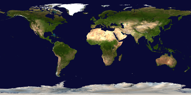
العربية: صور ساتليَّة مُجمَّعة لتُظهر سطح الأرض كاملًا.
English: This spectacular “blue marble” image is the most detailed true-color image of the entire Earth to date. Using a collection of satellite-based observations, scientists and visualizers stitched together months of observations of the land surface, oceans, sea ice, and clouds into a seamless, true-color mosaic of every square kilometer (.386 square mile) of our planet. These images are freely available to educators, scientists, museums, and the public.

Much of the information contained in this image came from a single remote-sensing device-NASA’s Moderate Resolution Imaging Spectroradiometer, or MODIS. Flying over 700 km above the Earth onboard the Terra satellite, MODIS provides an integrated tool for observing a variety of terrestrial, oceanic, and atmospheric features of the Earth. The land and coastal ocean portions of these images are based on surface observations collected from June through September 2001 and combined, or composited, every eight days to compensate for clouds that might block the sensor’s view of the surface on any single day.

Two different types of ocean data were used in these images: shallow water true color data, and global ocean color (or chlorophyll) data. Topographic shading is based on the GTOPO 30 elevation dataset compiled by the U.S. Geological Survey’s EROS Data Center. MODIS observations of polar sea ice were combined with observations of Antarctica made by the National Oceanic and Atmospheric Administration’s AVHRR sensor—the Advanced Very High Resolution Radiometer. The cloud image is a composite of two days of imagery collected in visible light wavelengths and a third day of thermal infra-red imagery over the poles. Global city lights, derived from 9 months of observations from the Defense Meteorological Satellite Program, are superimposed on a darkened land surface map.
تاریخ
ماخذ NASA Visible Earth: Blue Marble: Land Surface, Shallow Water, and Shaded Topography
مصنف NASA’s Terra satellite for the MODIS imageries, combined by Meow. Credit: NASA Goddard Space Flight Center Image by Reto Stöckli (land surface, shallow water, clouds). Enhancements by Robert Simmon (ocean color, compositing, 3D globes, animation). Data and technical support: MODIS Land Group; MODIS Science Data Support Team; MODIS Atmosphere Group; MODIS Ocean Group Additional data: USGS EROS Data Center (topography); USGS Terrestrial Remote Sensing Flagstaff Field Center (Antarctica); Defense Meteorological Satellite Program (city lights).
دوسرے نسخے

Assessment

Featured تصویر

ویکی ذخائرویکیپیڈیا

This is a featured picture on Wikimedia Commons (Featured pictures) and is considered one of the finest images. See its nomination here.

 This is a featured picture on the Arabic language Wikipedia (صور مختارة) and is considered one of the finest images. See its nomination here.
 This is a featured picture on the English language Wikipedia (Featured pictures) and is considered one of the finest images. See its nomination here.

If you have an image of similar quality that can be published under a suitable copyright license, be sure to upload it, tag it, and nominate it.

اجازہ کاری

Public domain This file is in the public domain in the United States because it was solely created by NASA. NASA copyright policy states that "NASA material is not protected by copyright unless noted". (See Template:PD-USGov, NASA copyright policy page or JPL Image Use Policy.)
Warnings:

Captions

Add a one-line explanation of what this file represents

Items portrayed in this file

عکاسی

11 فروری 2002

جولائی 3 CEگریگوری

MIME type انگریزی

image/png

checksum انگریزی

3db4ee4ab241d9afd554c54b1b657675a8643017

طریق تعیین: SHA-1 انگریزی

data size انگریزی

555,309,882 لکمہ

21,600 عکصر

43,200 عکصر

فائل کا تاریخچہ

کسی خاص وقت یا تاریخ میں یہ فائل کیسی نظر آتی تھی، اسے دیکھنے کے لیے اس وقت/تاریخ پر کلک کریں۔

تاریخ/وقتتھمب نیلابعادصارفتبصرہ
رائج الوقت10:34، 23 جولائی 2023ءمورخہ 10:34، 23 جولائی 2023ء کا تھمب نیل43,200 × 21,600 (529.58 MB)GioppolognomoReverted to version as of 11:53, 5 August 2016 (UTC)
10:28، 23 جولائی 2023ءمورخہ 10:28، 23 جولائی 2023ء کا تھمب نیل5,400 × 2,700 (41.8 MB)Gioppolognomo
11:53، 5 اگست 2016ءمورخہ 11:53، 5 اگست 2016ء کا تھمب نیل43,200 × 21,600 (529.58 MB)Meowc:User:Rillke/bigChunkedUpload.js:

درج ذیل صفحہ اس فائل کو استعمال کر رہا ہے:

فائل کا عالمی استعمال

مندرجہ ذیل ویکیوں میں یہ فائل زیر استعمال ہے: