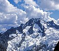
فائل:Bonanza Peak Washington.jpg

اس نمائش کا حجم: 694 × 599 پکسلز۔ دیگر تصمیمات: 278 × 240 پکسلز | 556 × 480 پکسلز۔
اصل فائل (800 × 691 پکسل، فائل کا حجم: 745 کلوبائٹ، MIME قسم: image/jpeg)
فائل کا تاریخچہ
کسی خاص وقت یا تاریخ میں یہ فائل کیسی نظر آتی تھی، اسے دیکھنے کے لیے اس وقت/تاریخ پر کلک کریں۔
| تاریخ/وقت | تھمب نیل | ابعاد | صارف | تبصرہ | |
|---|---|---|---|---|---|
| رائج الوقت | 04:41، 11 جنوری 2024ء |  | 800 × 691 (745 کلوبائٹ) | RodRabelo7 | Reverted to version as of 07:34, 1 April 2011 (UTC) as per Commons:Overwriting existing files#DO NOT overwrite: “✘ Artificially upscaling or enlarging using any tool, including AI-based or deep learning services” |
| 06:30، 7 نومبر 2023ء |  | 3,200 × 2,764 (3.68 MB) | Hike395 | better AI upscaling | |
| 14:40، 6 نومبر 2023ء |  | 1,600 × 1,382 (1.13 MB) | Hike395 | AI upscaling | |
| 07:34، 1 اپریل 2011ء |  | 800 × 691 (745 کلوبائٹ) | Hike395 | {{Information |Description ={{en|1=North face of Bonanza Peak, highest nonvolcanic peak in the North Cascade Range at {{convert|9511|ft|m}} elevation, viewed from south side of Mount Lyall. The massif is underlain by Marblemount meta-quartz diorite.}} |
روابط
درج ذیل 2 صفحات اس فائل کو استعمال کر رہے ہیں:
فائل کا عالمی استعمال
مندرجہ ذیل ویکیوں میں یہ فائل زیر استعمال ہے:
- arz.wikipedia.org پر استعمال
- ceb.wikipedia.org پر استعمال
- de.wikipedia.org پر استعمال
- en.wikipedia.org پر استعمال
- fa.wikipedia.org پر استعمال
- fr.wikipedia.org پر استعمال
- it.wikipedia.org پر استعمال
- ja.wikipedia.org پر استعمال
- lld.wikipedia.org پر استعمال
- pl.wikipedia.org پر استعمال
- ru.wikipedia.org پر استعمال
- www.wikidata.org پر استعمال
