فائل:British postcode areas map.svg

اس SVG فائل کی PNG نمائش کا حجم: 388 × 600 پکسلز دیگر تصمیمات: 155 × 240 پکسلز | 310 × 480 پکسلز | 497 × 768 پکسلز | 663 × 1,024 پکسلز | 1,325 × 2,048 پکسلز | 886 × 1,369 پکسلز۔
اصل فائل (ایس وی جی فائل، ابعاد 886 × 1,369 پکسل، فائل کا حجم: 846 کلوبائٹ)
W3C-validity not checked.
خلاصہ
| Camera location | | View this and other nearby images on: OpenStreetMap |
|---|
| تفصیل |
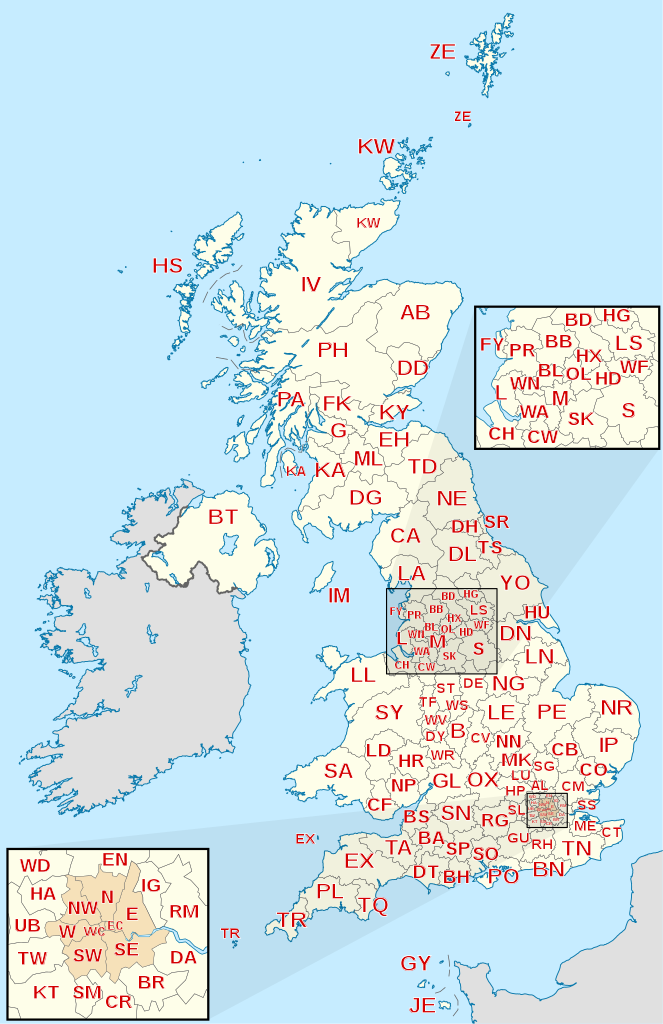
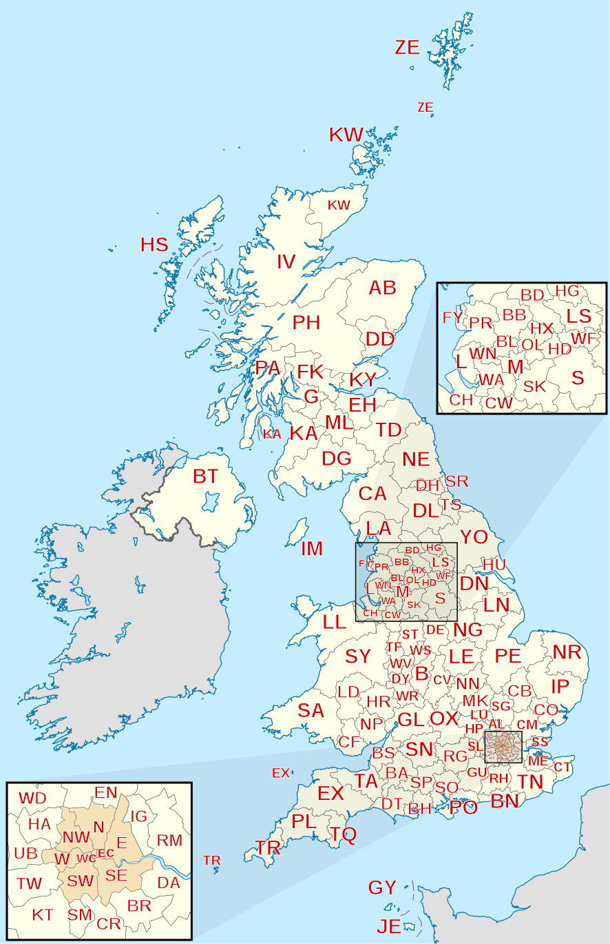
English: Labelled map of Royal Mail postcode areas of the United Kingdom and Crown Dependencies with insets for Manchester and London conurbations.
Equirectangular projection with latitude stretching 170%, WGS84 datum. Geographic limits:
|
| تاریخ | |
| ماخذ |
Derived from Ordnance Survey OS OpenData.
|
| مصنف | Richardguk |
| دوسرے نسخے |
|


اجازہ کاری
میں اس تخلیقی کام کے حقوق کا مالک ہوں اور اسے مندرجہ ذیل اجازت نامے کے تحت شائع کرتا ہوں:
اس ملف کا لائسنس Creative Commons Attribution-Share Alike 3.0 Unported کے تحط ہے۔
- آپ آزاد ہیں:
- شیئر کرنے – کام کو نقل، تقسیم یا منتقل کرنے کے لیے
- ریمکس کے لیے – کام منبطق کرنے کے لیے
- مندرجہ ذیل شرائط کے تحت:
- انتساب – آپ کو اس کام کا انتساب مصنف یا اجازت دہندہ کے بتائے گئے طریقہ کے مطابق دینا ہوگا (تاہم یہ انتساب اس طرح نہیں ہونا چاہیے کہ اسے دیکھ کر ایسا محسوس ہو کہ اصل مصنف یا اجازت دہندہ آپ کے یا آپ کے ذریعہ اس کام کے استعمال کرنے کے حامی ہیں)۔
- یکساں شراکت – اگر آپ اس کام میں کوئی تبدیلی یا ترمیم کرتے ہیں یا اس کام پر مبنی کچھ نیا بناتے ہیں تو اسے بھی آپ اسی یا اس جیسے کسی اجازت نامے کے تحت شائع کر سکتے ہیں۔
This file is licensed by the Ordnance Survey of the United Kingdom under their OS OpenData License
In short: you are free to distribute and modify the file as long as you attribute (including year), the Ordnance Survey and Royal Mail. لگاؤ: Contains Ordnance Survey and Royal Mail data © Crown copyright and database right (year) Note: Derivative works can be licensed under any Creative Commons Attribution 3.0 Licence. |
.svg)
|
This file is licensed under the United Kingdom Open Government Licence v3.0. |
See also: Meta for information on usage on Wikimedia wikis.
|
This vector image includes elements that have been taken or adapted from this file:
فائل کا تاریخچہ
کسی خاص وقت یا تاریخ میں یہ فائل کیسی نظر آتی تھی، اسے دیکھنے کے لیے اس وقت/تاریخ پر کلک کریں۔
| تاریخ/وقت | تھمب نیل | ابعاد | صارف | تبصرہ | |
|---|---|---|---|---|---|
| رائج الوقت | 05:45، 28 جنوری 2012ء | | 886 × 1,369 (846 کلوبائٹ) | Richardguk | Clipped postcode area strokes to GB mainland (requires non-rectangular clip-path renderer); added dashed strokes to clarify nearby offshore postcode area boundaries (France–GY, France–JE, GY–JE, HS–IV, IV–PH, KA–PA, PA–PH); font-family="'Lib |
| 22:00، 1 دسمبر 2011ء |  | 886 × 1,369 (844 کلوبائٹ) | Richardguk | Main map limits and coastline taken from File:United Kingdom location map.svg. Label sizes refined. Colour-scheme amended for greater similarity with UK location maps. SVG out | |
| 16:19، 25 نومبر 2011ء |  | 498 × 986 (368 کلوبائٹ) | Richardguk |
روابط
درج ذیل 2 صفحات اس فائل کو استعمال کر رہے ہیں:
فائل کا عالمی استعمال
مندرجہ ذیل ویکیوں میں یہ فائل زیر استعمال ہے:
- cy.wikipedia.org پر استعمال
- de.wikipedia.org پر استعمال
- en.wikipedia.org پر استعمال
- fr.wikipedia.org پر استعمال
- gu.wikipedia.org پر استعمال
- hi.wikipedia.org پر استعمال
- it.wikipedia.org پر استعمال
- kn.wikipedia.org پر استعمال
- simple.wikipedia.org پر استعمال