فائل:Carte du royaume de Siam et des pays circonvoisins 1686.jpg

اس نمائش کا حجم: 434 × 600 پکسلز۔ دیگر تصمیمات: 174 × 240 پکسلز | 347 × 480 پکسلز | 556 × 768 پکسلز | 741 × 1,024 پکسلز | 1,482 × 2,048 پکسلز | 2,831 × 3,912 پکسلز۔
اصل فائل (2,831 × 3,912 پکسل، فائل کا حجم: 2.34 MB، MIME قسم: image/jpeg)
خلاصہ
| تفصیل |
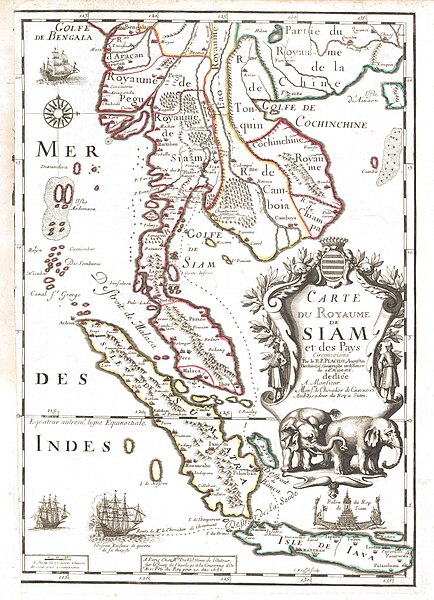
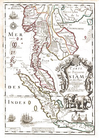
English: Map of the Kingdom of Siam and its neighbouring countries Français : Carte du royaume de Siam et des pays circonvoisins |
| تاریخ | |
| ماخذ | [1] |
| مصنف | R. Placide Augustin Dechaussé (Paris 1649 - ibidem 1734), augustin déchaussé, géographe ordinaire de Sa Majesté |
| دوسرے نسخے | BNF |
اجازہ کاری
|
This is a faithful photographic reproduction of a two-dimensional, public domain work of art. The work of art itself is in the public domain for the following reason:
The official position taken by the Wikimedia Foundation is that "faithful reproductions of two-dimensional public domain works of art are public domain".
This photographic reproduction is therefore also considered to be in the public domain in the United States. In other jurisdictions, re-use of this content may be restricted; see Reuse of PD-Art photographs for details. | ||||
فائل کا تاریخچہ
کسی خاص وقت یا تاریخ میں یہ فائل کیسی نظر آتی تھی، اسے دیکھنے کے لیے اس وقت/تاریخ پر کلک کریں۔
| تاریخ/وقت | تھمب نیل | ابعاد | صارف | تبصرہ | |
|---|---|---|---|---|---|
| رائج الوقت | 12:18، 8 فروری 2018ء | | 2,831 × 3,912 (2.34 MB) | Gryffindor | {{Information |Description= |Source= |Date= |Author= |Permission= |other_versions= }} |
| 11:35، 25 دسمبر 2014ء |  | 1,960 × 2,822 (2.73 MB) | Sodacan | contrasts | |
| 20:45، 4 نومبر 2008ء |  | 1,960 × 2,822 (2.48 MB) | World Imaging | Category:History of Thailand | |
| 14:07، 18 مئی 2008ء |  | 558 × 900 (113 کلوبائٹ) | World Imaging | Better image | |
| 13:41، 18 مئی 2008ء |  | 558 × 900 (157 کلوبائٹ) | World Imaging | {{Information |Description=1686 French Map Of Siam |Source=1686 map. Reproduction in [http://www.escati.com/the-making-of-a-nation/]] |Date=1686 |Author=Unknown |Permission= |other_versions= }} |
روابط
درج ذیل 2 صفحات اس فائل کو استعمال کر رہے ہیں:
فائل کا عالمی استعمال
مندرجہ ذیل ویکیوں میں یہ فائل زیر استعمال ہے:
- af.wikipedia.org پر استعمال
- ar.wikipedia.org پر استعمال
- ba.wikipedia.org پر استعمال
- ckb.wikipedia.org پر استعمال
- cs.wikipedia.org پر استعمال
- de.wikipedia.org پر استعمال
- de.wikivoyage.org پر استعمال
- en.wikipedia.org پر استعمال
- History of Thailand
- Ayutthaya Kingdom
- Post-Angkor period
- Srivijaya
- History of Isan
- History of Thailand (1973–2001)
- Early history of Thailand
- Rattanakosin Kingdom (1782–1932)
- History of Thailand (1932–1973)
- Template:History of Thailand
- Template talk:History of Thailand
- Military history of Thailand
- Thonburi Kingdom
- Tambralinga
- Initial states of Thailand
- Singhanavati
- Prehistoric Thailand
- User talk:67.150.126.108
- History of Phitsanulok Province
- Peopling of Thailand
- France–Thailand relations
- User:UBX/Thailand
- User:Thailand~enwiki
- User:Pawyilee/Crawfurd Mission
- User:༆/History of Asia templates
- History of Thailand (2001–present)
- User:ผู้บ่าวไทบ้าน/sandbox
- Anglo-Siamese War
- User:Lalalulilalia/sandbox
- Malay invasions of Sri Lanka
- User:Nickicooo/Siam's annexation of Chiang Mai
- Canasapura
- Draft:Sri Kotrabun
- Wen Dan
- fi.wikipedia.org پر استعمال
- fr.wikipedia.org پر استعمال
- hr.wiktionary.org پر استعمال
- id.wikipedia.org پر استعمال
اس فائل کا مزید عالمی استعمال دیکھیے۔