Columbia_Island_-_aerial_view_2005.jpg (473 × 406 پکسل، فائل کا حجم: 240 کلوبائٹ، MIME قسم: image/jpeg)

یہ فائل ویکی ذخائر کی ہے اور دیگر منصوبوں کے زیر استعمال ہوسکتی ہے۔ فائل کے صفحہ تعارف پر موجود تعارف ذیل میں موجود ہے۔

خلاصہ

تفصیل
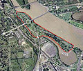
English: Aerial view of Columbia Island (outlined in red) in the Potomac River in Washington, D.C., in the United States.

Arlington Memorial Bridge enters the island from the northeast, connecting it to the Lincoln Memorial. A large memorial plaza and traffic circle, constructed in the 1930s, connects Arlington Memorial Bridge to Lee Highway, the George Washington Memorial Parkway, and the Boundary Channel Bridge. The many piers of the Columbia Island Marina jut into the Bounday Channel and Pentagon Lagoon on the southwest corner of the island.

The Potomac River runs along the island to the northwest. The Lincoln Memorial and a portion of the Tidal Basin can also be seen.

The Boundary Channel (west and southwest of the island) is part of the Potomac River. The Boundary Channel Bridge links Columbia Island to Memorial Drive and the ceremonial entrance to Arlington National Cemetery (left side of the image). The Pentagon can be seen to the bottom of the image, and just north of that its large parking lots.

Upstream (upper center portion of this image) is the Theodore Roosevelt Bridge, and Theodore Roosevelt Island. The skyscrapers of Rossyln, Virginia, can just be seen in the far upper left corner of the image.
تاریخ
ماخذ File:Washington_77.04477W_38.88819N.jpg
مصنف NASA


Public domain This file is in the public domain in the United States because it was solely created by NASA. NASA copyright policy states that "NASA material is not protected by copyright unless noted". (See Template:PD-USGov, NASA copyright policy page or JPL Image Use Policy.)
Warnings:

اجازہ کاری

Captions

Add a one-line explanation of what this file represents

Items portrayed in this file

عکاسی

media type انگریزی

image/jpeg

checksum انگریزی

1d22d2c28309637a64265673c7f24fdd50cdb821

data size انگریزی

246,042 لکمہ

406 عکصر

473 عکصر

فائل کا تاریخچہ

کسی خاص وقت یا تاریخ میں یہ فائل کیسی نظر آتی تھی، اسے دیکھنے کے لیے اس وقت/تاریخ پر کلک کریں۔

تاریخ/وقتتھمب نیلابعادصارفتبصرہ
رائج الوقت18:23، 6 مئی 2013ءمورخہ 18:23، 6 مئی 2013ء کا تھمب نیل473 × 406 (240 کلوبائٹ)Tim1965{{Information |Description ={{en|1=Aerial view of Columbia Island (outlined in red) in the Potomac River in Washington, D.C., in the United States. Arlington Memorial Bridge enters the island from the northeast, connecting it to the Lincoln Memoria...

درج ذیل صفحہ اس فائل کو استعمال کر رہا ہے:

فائل کا عالمی استعمال

مندرجہ ذیل ویکیوں میں یہ فائل زیر استعمال ہے:

میٹا ڈیٹا